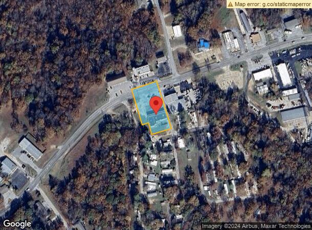
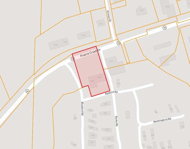
Property Record
14449 E Highway 12, Rogers, AR 72756

NEARBY LISTINGS FOR SALE OR LEASE
-
-
View all Rogers listings for sale on LoopNet.com
Property Detail
14449 E Highway 12
18-03212-000
Rural
Storebuilding
PT SW SW BEG NW/C NW NW S87*W149 N12*E141 N2*W231 N40*E109 N77*E68 N59*E58 N72*E5 POB N17*W224 CURVE R N71*E22 N72*E17 S17*E225 S72*W40 POB ALSO BEG NW/C NW NW SEC 10 87*E144 N6*W149 N12*E141 ETC
X
Benton
05007C0285J
Arkansas
2025
1.07 AC
2025
Outer Central Benton County
020203
Fayetteville/Springdale/Rogers
5,196 SF
Fayetteville-Springdale-Rogers, AR-MO
DEMOGRAPHICS near 14449 E Highway 12
1 Mile
3 Mile
5 Mile
2024 Total Population
1,892
11,405
51,498
2029 Population
2,210
13,434
60,242
Pop Growth 2024-2029
+ 16.81%
+ 17.79%
+ 16.98%
Average Age
47
42
38
2024 Total Households
760
4,169
18,108
HH Growth 2024-2029
+ 16.84%
+ 17.82%
+ 17.06%
Median Household Inc
$91,626
$76,804
$60,660
Avg Household Size
2.50
2.70
2.70
2024 Avg HH Vehicles
2.00
2.00
2.00
Median Home Value
$309,375
$248,437
$199,476
Median Year Built
1991
1991
1989
Nearby Places
Map Layers
Map Styles
 Street
 Aerial
- Restaurants
- Banks
- Shops
- Fitness
- Groceries
PUBLIC TRANSPORTATION
AIRPORT
Northwest Arkansas Ntl
DRIVE
WALK
Distance
Northwest Arkansas Ntl
38 min
18.8 mi
Freight Ports
Tulsa Port of Inola
DRIVE
WALK
Distance
Tulsa Port of Inola
123 min
100.9 mi
Nearby Properties
Address
Land Use
TOTAL SIZE
Lot Size
Zoning
Address
Land Use
TOTAL SIZE
Lot Size
Zoning
68,422 SF
6.14 AC
Address
Land Use
TOTAL SIZE
Lot Size
Zoning
17,377 SF
0.79 AC
Address
Land Use
TOTAL SIZE
Lot Size
Zoning
3,531 SF
0.02 AC
Address
Land Use
TOTAL SIZE
Lot Size
Zoning
21,482 SF
3.90 AC
Address
Land Use
TOTAL SIZE
Lot Size
Zoning
47,580 SF
17.60 AC
Address
Land Use
TOTAL SIZE
Lot Size
Zoning
35,700 SF
5.63 AC
Address
Land Use
TOTAL SIZE
Lot Size
Zoning
23,485 SF
1.70 AC
Address
Land Use
TOTAL SIZE
Lot Size
Zoning
54,220 SF
7.46 AC
Address
Land Use
TOTAL SIZE
Lot Size
Zoning
14,000 SF
3.99 AC
Address
Land Use
TOTAL SIZE
Lot Size
Zoning
10,400 SF
69 AC
Address
Land Use
TOTAL SIZE
Lot Size
Zoning
8,491 SF
19.82 AC
Address
Land Use
TOTAL SIZE
Lot Size
Zoning
47,624 SF
4.91 AC
Address
Land Use
TOTAL SIZE
Lot Size
Zoning
26,670 SF
3.23 AC
Address
Land Use
TOTAL SIZE
Lot Size
Zoning
40,615 SF
6.58 AC
Address
Land Use
TOTAL SIZE
Lot Size
Zoning
2,552 SF
0.08 AC
Address
Land Use
TOTAL SIZE
Lot Size
Zoning
22,792 SF
1.70 AC
Address
Land Use
TOTAL SIZE
Lot Size
Zoning
8,000 SF
1.75 AC
Address
Land Use
TOTAL SIZE
Lot Size
Zoning
20,329 SF
4.54 AC
Address
Land Use
TOTAL SIZE
Lot Size
Zoning
4,976 SF
0.79 AC
Address
Land Use
TOTAL SIZE
Lot Size
Zoning
4,633 SF
1.06 AC
Address
Land Use
TOTAL SIZE
Lot Size
Zoning
13,218 SF
1.19 AC
Address
Land Use
TOTAL SIZE
Lot Size
Zoning
12,151 SF
1.08 AC
Address
Land Use
TOTAL SIZE
Lot Size
Zoning
8,160 SF
8.24 AC
Address
Land Use
TOTAL SIZE
Lot Size
Zoning
16,000 SF
1.18 AC
Address
Land Use
TOTAL SIZE
Lot Size
Zoning
16,672 SF
1.83 AC
Address
Land Use
TOTAL SIZE
Lot Size
Zoning
5,224 SF
0.84 AC
Address
Land Use
TOTAL SIZE
Lot Size
Zoning
11,796 SF
2.61 AC
Address
Land Use
TOTAL SIZE
Lot Size
Zoning
26,764 SF
7.43 AC
Address
Land Use
TOTAL SIZE
Lot Size
Zoning
2,280 SF
17.35 AC
Address
Land Use
TOTAL SIZE
Lot Size
Zoning
9,196 SF
1.52 AC
The World's #1 Commercial Real Estate Marketplace
Connect with us
© 2026 CoStar Group
The information above has been obtained from sources believed reliable. While we do not doubt its accuracy we have not verified it and make no guarantee, warranty or representation about it. It is your responsibility to independently confirm its accuracy and completeness. Any projections, opinions, assumptions, or estimates used are for example only and do not represent the current or future performance of the property. The value of this transaction to you depends on tax and other factors which should be evaluated by your tax, financial, and legal advisors. You and your advisors should conduct a careful, independent investigation of the property to determine to your satisfaction the suitability of the property for your needs.