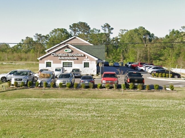
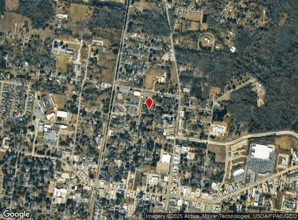
Property Record
14455 Arleen Ave, Zachary, LA 70791

NEARBY LISTINGS FOR SALE OR LEASE
-
-
View all Zachary listings for sale on LoopNet.com
Property Detail
14455 Arleen Ave
Baton Rouge, LA
Kleinpeter, Lillian G. Tract
30835533
WARD: 3-0, SUBDIVISION: KLEINPETER, LILLIAN G. TRACT, LOT: B-1-B-3-A-2. TRACT B-1-B-3-A-2, CONT 0.689 ACRES, RESUB OF TRACT B-1-B-3-A OF THE THE LILLIAN G KLEINPETER TRACT, LOCATED IN SEC 51, T8S, R2E RESUB 2001-11-12-17-19
Storesoffices
E Baton Rouge
X
Louisiana
22033C0065F
b-1-
2024
0.69 AC
2024
Sherwood Forest
004602
Baton Rouge
DEMOGRAPHICS near 14455 Arleen Ave
1 Mile
3 Mile
5 Mile
2024 Total Population
2,281
41,833
107,048
2029 Population
2,215
40,979
105,795
Pop Growth 2024-2029
(2.89%)
(2.04%)
(1.17%)
Average Age
38
40
40
2024 Total Households
927
16,611
43,810
HH Growth 2024-2029
(3.02%)
(2.20%)
(1.43%)
Median Household Inc
$74,858
$86,592
$79,463
Avg Household Size
2.40
2.50
2.40
2024 Avg HH Vehicles
2.00
2.00
2.00
Median Home Value
$255,312
$283,647
$281,532
Median Year Built
1990
1993
1991
Nearby Places
Map Layers
Map Styles
 Street
 Aerial
- Restaurants
- Banks
- Shops
- Fitness
- Groceries
PUBLIC TRANSPORTATION
AIRPORT
Baton Rouge Metro Ryan Field
DRIVE
WALK
Distance
Baton Rouge Metro Ryan Field
18 min
11.2 mi
Freight Ports
Port of Greater Baton Rouge
DRIVE
WALK
Distance
Port of Greater Baton Rouge
32 min
19.9 mi
Nearby Properties
Address
Land Use
TOTAL SIZE
Lot Size
Zoning
Address
Land Use
TOTAL SIZE
Lot Size
Zoning
22.22 AC
Address
Land Use
TOTAL SIZE
Lot Size
Zoning
111,912 SF
28.33 AC
Address
Land Use
TOTAL SIZE
Lot Size
Zoning
15.41 AC
Address
Land Use
TOTAL SIZE
Lot Size
Zoning
Address
Land Use
TOTAL SIZE
Lot Size
Zoning
102,720 SF
10 AC
Address
Land Use
TOTAL SIZE
Lot Size
Zoning
82,615 SF
15.71 AC
Address
Land Use
TOTAL SIZE
Lot Size
Zoning
156,100 SF
16.32 AC
Address
Land Use
TOTAL SIZE
Lot Size
Zoning
9,994 SF
11.40 AC
Address
Land Use
TOTAL SIZE
Lot Size
Zoning
61,274 SF
2.91 AC
Address
Land Use
TOTAL SIZE
Lot Size
Zoning
102,513 SF
14.22 AC
Address
Land Use
TOTAL SIZE
Lot Size
Zoning
5.84 AC
Address
Land Use
TOTAL SIZE
Lot Size
Zoning
17,537 SF
20 AC
Address
Land Use
TOTAL SIZE
Lot Size
Zoning
47,750 SF
5.89 AC
Address
Land Use
TOTAL SIZE
Lot Size
Zoning
52,600 SF
11.31 AC
Address
Land Use
TOTAL SIZE
Lot Size
Zoning
2,668 SF
2.46 AC
Address
Land Use
TOTAL SIZE
Lot Size
Zoning
28,800 SF
3.26 AC
Address
Land Use
TOTAL SIZE
Lot Size
Zoning
Address
Land Use
TOTAL SIZE
Lot Size
Zoning
9,012 SF
2.72 AC
Address
Land Use
TOTAL SIZE
Lot Size
Zoning
Address
Land Use
TOTAL SIZE
Lot Size
Zoning
24,450 SF
2.26 AC
Address
Land Use
TOTAL SIZE
Lot Size
Zoning
35,982 SF
12.58 AC
Address
Land Use
TOTAL SIZE
Lot Size
Zoning
Address
Land Use
TOTAL SIZE
Lot Size
Zoning
99,786 SF
0.17 AC
Address
Land Use
TOTAL SIZE
Lot Size
Zoning
Address
Land Use
TOTAL SIZE
Lot Size
Zoning
40,188 SF
16.58 AC
Address
Land Use
TOTAL SIZE
Lot Size
Zoning
61,894 SF
1.50 AC
Address
Land Use
TOTAL SIZE
Lot Size
Zoning
Address
Land Use
TOTAL SIZE
Lot Size
Zoning
13,645 SF
3.38 AC
Address
Land Use
TOTAL SIZE
Lot Size
Zoning
1.24 AC
Address
Land Use
TOTAL SIZE
Lot Size
Zoning
35,751 SF
13.36 AC
The World's #1 Commercial Real Estate Marketplace
Connect with us
© 2025 CoStar Group
The information above has been obtained from sources believed reliable. While we do not doubt its accuracy we have not verified it and make no guarantee, warranty or representation about it. It is your responsibility to independently confirm its accuracy and completeness. Any projections, opinions, assumptions, or estimates used are for example only and do not represent the current or future performance of the property. The value of this transaction to you depends on tax and other factors which should be evaluated by your tax, financial, and legal advisors. You and your advisors should conduct a careful, independent investigation of the property to determine to your satisfaction the suitability of the property for your needs.