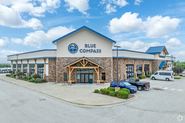
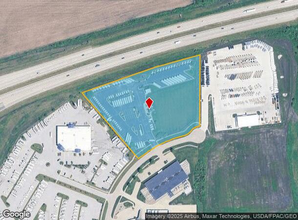
Property Record
1446 Northridge Cir, Altoona, IA 50009

NEARBY LISTINGS FOR SALE OR LEASE
Property Detail
1446 Northridge Cir
Des Moines-West Des Moines, IA
Franzen Plat 1
171-00360187329
-EX BEG NW COR THN NE 41.78F NELY 372.11 ALNG CRV SW 410.32F TO PT ON W LN NW 4.4F TO POB- LOT 9 FRANZEN PLAT 1
Vehiclerentalsvehiclesales
Polk
X
Iowa
19153C0240F
9
2024
5.92 AC
2025
Northeast
010703
Des Moines
1,068 SF
DEMOGRAPHICS near 1446 Northridge Cir
1 Mile
3 Mile
5 Mile
2024 Total Population
1,281
27,007
43,491
2029 Population
1,386
28,408
45,841
Pop Growth 2024-2029
+ 8.20%
+ 5.19%
+ 5.40%
Average Age
36
37
37
2024 Total Households
453
9,862
15,973
HH Growth 2024-2029
+ 8.39%
+ 5.18%
+ 5.45%
Median Household Inc
$102,644
$89,986
$84,602
Avg Household Size
2.80
2.70
2.70
2024 Avg HH Vehicles
2.00
2.00
2.00
Median Home Value
$343,846
$256,952
$254,845
Median Year Built
2009
2001
2001
Nearby Places
Map Layers
Map Styles
 Street
 Aerial
- Restaurants
- Banks
- Shops
- Fitness
- Groceries
PUBLIC TRANSPORTATION
AIRPORT
Des Moines International
DRIVE
WALK
Distance
Des Moines International
31 min
18.7 mi
Nearby Properties
Address
Land Use
TOTAL SIZE
Lot Size
Zoning
Address
Land Use
TOTAL SIZE
Lot Size
Zoning
1,089,208 SF
145.90 AC
Address
Land Use
TOTAL SIZE
Lot Size
Zoning
1,018,608 SF
190.56 AC
Address
Land Use
TOTAL SIZE
Lot Size
Zoning
2,693,534 SF
167.13 AC
Address
Land Use
TOTAL SIZE
Lot Size
Zoning
549,615 SF
149.20 AC
C6
Address
Land Use
TOTAL SIZE
Lot Size
Zoning
497,587 SF
31.46 AC
Address
Land Use
TOTAL SIZE
Lot Size
Zoning
459,000 SF
19.69 AC
Address
Land Use
TOTAL SIZE
Lot Size
Zoning
397,563 SF
18.25 AC
Address
Land Use
TOTAL SIZE
Lot Size
Zoning
314,940 SF
10.08 AC
Address
Land Use
TOTAL SIZE
Lot Size
Zoning
327,600 SF
16.57 AC
Address
Land Use
TOTAL SIZE
Lot Size
Zoning
212,388 SF
40.63 AC
Address
Land Use
TOTAL SIZE
Lot Size
Zoning
325,160 SF
17.24 AC
Address
Land Use
TOTAL SIZE
Lot Size
Zoning
359,441 SF
173.80 AC
C6
Address
Land Use
TOTAL SIZE
Lot Size
Zoning
259,056 SF
16.31 AC
Address
Land Use
TOTAL SIZE
Lot Size
Zoning
302,604 SF
16.46 AC
Address
Land Use
TOTAL SIZE
Lot Size
Zoning
265,726 SF
14.76 AC
Address
Land Use
TOTAL SIZE
Lot Size
Zoning
300,000 SF
18.95 AC
Address
Land Use
TOTAL SIZE
Lot Size
Zoning
300,000 SF
20.09 AC
Address
Land Use
TOTAL SIZE
Lot Size
Zoning
270,000 SF
18.35 AC
Address
Land Use
TOTAL SIZE
Lot Size
Zoning
270,000 SF
14.55 AC
Address
Land Use
TOTAL SIZE
Lot Size
Zoning
142,032 SF
10 AC
Address
Land Use
TOTAL SIZE
Lot Size
Zoning
195,500 SF
15.03 AC
Address
Land Use
TOTAL SIZE
Lot Size
Zoning
195,500 SF
8.09 AC
Address
Land Use
TOTAL SIZE
Lot Size
Zoning
167,308 SF
16.46 AC
Address
Land Use
TOTAL SIZE
Lot Size
Zoning
78,180 SF
7.31 AC
Address
Land Use
TOTAL SIZE
Lot Size
Zoning
135,824 SF
13.22 AC
Address
Land Use
TOTAL SIZE
Lot Size
Zoning
183,595 SF
19.31 AC
C-2
Address
Land Use
TOTAL SIZE
Lot Size
Zoning
117,924 SF
4.76 AC
R-5
Address
Land Use
TOTAL SIZE
Lot Size
Zoning
49,145 SF
6.06 AC
Address
Land Use
TOTAL SIZE
Lot Size
Zoning
91,388 SF
14.50 AC
M-1
The World's #1 Commercial Real Estate Marketplace
Connect with us
© 2025 CoStar Group
The information above has been obtained from sources believed reliable. While we do not doubt its accuracy we have not verified it and make no guarantee, warranty or representation about it. It is your responsibility to independently confirm its accuracy and completeness. Any projections, opinions, assumptions, or estimates used are for example only and do not represent the current or future performance of the property. The value of this transaction to you depends on tax and other factors which should be evaluated by your tax, financial, and legal advisors. You and your advisors should conduct a careful, independent investigation of the property to determine to your satisfaction the suitability of the property for your needs.