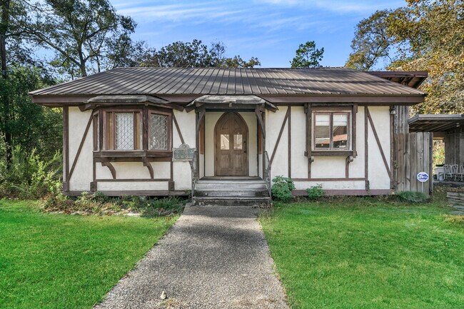
Property Record
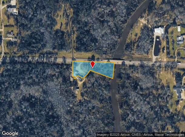
14476 Highway 22, Ponchatoula, LA 70454

NEARBY LISTINGS FOR SALE OR LEASE
Property Detail
14476 Highway 22
05036518
1.50A BEING TRACT 1 OF SCHOEFFLER MINI PARTITION IN SEC 57 T7SR7E B214 P607 B215 P240 B352 P599 B914 P898 B1277 P188 B1280 P6
Commercialnec
Tangipahoa
A
Louisiana
22063C0325E
1.50 AC
2024
Louisiana South Area
2024
Other Market Areas
954700
Hammond, LA
3,709 SF
DEMOGRAPHICS near 14476 Highway 22
1 Mile
3 Mile
5 Mile
2024 Total Population
1,392
18,280
48,316
2029 Population
1,502
19,694
52,396
Pop Growth 2024-2029
+ 7.90%
+ 7.74%
+ 8.44%
Average Age
41
40
39
2024 Total Households
537
7,267
18,830
HH Growth 2024-2029
+ 8.01%
+ 7.76%
+ 8.52%
Median Household Inc
$73,806
$58,989
$53,760
Avg Household Size
2.60
2.50
2.40
2024 Avg HH Vehicles
2.00
2.00
2.00
Median Home Value
$272,454
$230,111
$207,118
Median Year Built
2003
1999
1995
Nearby Places
Map Layers
Map Styles
 Street
 Aerial
- Restaurants
- Banks
- Shops
- Fitness
- Groceries
PUBLIC TRANSPORTATION
COMMUTER RAIL
Hammond Amtrak Station (City of New Orleans - Amtrak)
DRIVE
WALK
Distance
Hammond Amtrak Station (City of New Orleans - Amtrak)
10 min
6.5 mi
Freight Ports
Port of Greater Baton Rouge
DRIVE
WALK
Distance
Port of Greater Baton Rouge
61 min
50.9 mi
SALE & LEASE HISTORY
LISTING DATE
SALE/LEASE

Mar 31, 2020
For Sale
Jan 02, 2024
For Sale
Nearby Properties
Address
Land Use
TOTAL SIZE
Lot Size
Zoning
Address
Land Use
TOTAL SIZE
Lot Size
Zoning
Address
Land Use
TOTAL SIZE
Lot Size
Zoning
22.56 AC
Address
Land Use
TOTAL SIZE
Lot Size
Zoning
152,841 SF
20.69 AC
Address
Land Use
TOTAL SIZE
Lot Size
Zoning
84,000 SF
8.32 AC
Address
Land Use
TOTAL SIZE
Lot Size
Zoning
82,860 SF
11.42 AC
Address
Land Use
TOTAL SIZE
Lot Size
Zoning
24,931 SF
2.67 AC
Address
Land Use
TOTAL SIZE
Lot Size
Zoning
24,823 SF
3 AC
Address
Land Use
TOTAL SIZE
Lot Size
Zoning
36,593 SF
1.54 AC
Address
Land Use
TOTAL SIZE
Lot Size
Zoning
27,215 SF
7.58 AC
Address
Land Use
TOTAL SIZE
Lot Size
Zoning
96,064 SF
5.03 AC
Address
Land Use
TOTAL SIZE
Lot Size
Zoning
22,507 SF
0.63 AC
Address
Land Use
TOTAL SIZE
Lot Size
Zoning
120,800 SF
10 AC
Address
Land Use
TOTAL SIZE
Lot Size
Zoning
10,753 SF
1.57 AC
Address
Land Use
TOTAL SIZE
Lot Size
Zoning
61,230 SF
9.79 AC
Address
Land Use
TOTAL SIZE
Lot Size
Zoning
50,000 SF
5.78 AC
Address
Land Use
TOTAL SIZE
Lot Size
Zoning
24,040 SF
2.08 AC
Address
Land Use
TOTAL SIZE
Lot Size
Zoning
80,000 SF
11.02 AC
Address
Land Use
TOTAL SIZE
Lot Size
Zoning
11,595 SF
25.66 AC
Address
Land Use
TOTAL SIZE
Lot Size
Zoning
10,944 SF
2.16 AC
Address
Land Use
TOTAL SIZE
Lot Size
Zoning
16,780 SF
8.41 AC
Address
Land Use
TOTAL SIZE
Lot Size
Zoning
25,312 SF
3.68 AC
Address
Land Use
TOTAL SIZE
Lot Size
Zoning
25,000 SF
4.63 AC
Address
Land Use
TOTAL SIZE
Lot Size
Zoning
13,288 SF
15.07 AC
Address
Land Use
TOTAL SIZE
Lot Size
Zoning
67,728 SF
6.78 AC
Address
Land Use
TOTAL SIZE
Lot Size
Zoning
10,391 SF
1.94 AC
Address
Land Use
TOTAL SIZE
Lot Size
Zoning
96,000 SF
7.29 AC
Address
Land Use
TOTAL SIZE
Lot Size
Zoning
6,873 SF
1.58 AC
Address
Land Use
TOTAL SIZE
Lot Size
Zoning
12,021 SF
1.15 AC
Address
Land Use
TOTAL SIZE
Lot Size
Zoning
10,692 SF
5.49 AC
Address
Land Use
TOTAL SIZE
Lot Size
Zoning
13,075 SF
6.37 AC
The World's #1 Commercial Real Estate Marketplace
Connect with us
© 2025 CoStar Group
The information above has been obtained from sources believed reliable. While we do not doubt its accuracy we have not verified it and make no guarantee, warranty or representation about it. It is your responsibility to independently confirm its accuracy and completeness. Any projections, opinions, assumptions, or estimates used are for example only and do not represent the current or future performance of the property. The value of this transaction to you depends on tax and other factors which should be evaluated by your tax, financial, and legal advisors. You and your advisors should conduct a careful, independent investigation of the property to determine to your satisfaction the suitability of the property for your needs.