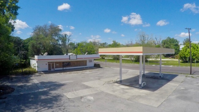
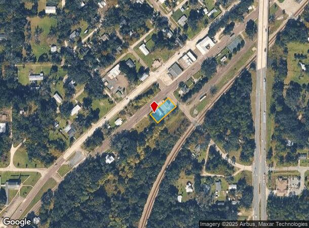
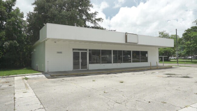
Property Record
14485 Cole St, Waldo, FL 32694
NEARBY LISTINGS FOR SALE OR LEASE
Property Detail
14485 Cole St
Gainesville, FL
Original Waldo
17168-001-000
ORIGINAL WALDO LOTS 1 2 3 4 5 BK 4 LESS R/W OR 5154/0814
Departmentstore
Alachua
X
Florida
12001C0195E
1
2025
0.26 AC
2025
Gainesville
001907
Other Market Areas
2,224 SF
DEMOGRAPHICS near 14485 Cole St
1 Mile
3 Mile
5 Mile
2024 Total Population
845
1,400
2,803
2029 Population
886
1,470
2,939
Pop Growth 2024-2029
+ 4.85%
+ 5.00%
+ 4.85%
Average Age
44
44
45
2024 Total Households
354
605
1,183
HH Growth 2024-2029
+ 4.80%
+ 4.79%
+ 4.65%
Median Household Inc
$33,333
$36,617
$46,336
Avg Household Size
2.30
2.30
2.30
2024 Avg HH Vehicles
2.00
2.00
2.00
Median Home Value
$150,471
$146,666
$150,919
Median Year Built
1977
1979
1982
Nearby Places
Map Layers
Map Styles
 Street
 Aerial
- Restaurants
- Banks
- Shops
- Fitness
- Groceries
PUBLIC TRANSPORTATION
AIRPORT
Gainesville Regional
DRIVE
WALK
Distance
Gainesville Regional
19 min
11.9 mi
Freight Ports
Jacksonville Port
DRIVE
WALK
Distance
Jacksonville Port
78 min
61.2 mi
SALE & LEASE HISTORY
LISTING DATE
SALE/LEASE

May 01, 2019
For Sale
Jun 01, 2023
For Sale
Jul 24, 2022
For Lease
Apr 20, 2019
For Sale
Nearby Properties
Address
Land Use
TOTAL SIZE
Lot Size
Zoning
Address
Land Use
TOTAL SIZE
Lot Size
Zoning
1,288 SF
18.43 AC
W301
Address
Land Use
TOTAL SIZE
Lot Size
Zoning
24,076 SF
2 AC
W301
Address
Land Use
TOTAL SIZE
Lot Size
Zoning
38,426 SF
7.16 AC
CC
Address
Land Use
TOTAL SIZE
Lot Size
Zoning
30,134 SF
3.41 AC
RESMED
Address
Land Use
TOTAL SIZE
Lot Size
Zoning
19,220 SF
2.84 AC
RESMED
Address
Land Use
TOTAL SIZE
Lot Size
Zoning
9,645 SF
4 AC
W301
Address
Land Use
TOTAL SIZE
Lot Size
Zoning
24,000 SF
4.70 AC
COMM
Address
Land Use
TOTAL SIZE
Lot Size
Zoning
21,792 SF
39.70 AC
W301
Address
Land Use
TOTAL SIZE
Lot Size
Zoning
13,640 SF
1.84 AC
W301
Address
Land Use
TOTAL SIZE
Lot Size
Zoning
5,316 SF
89.93 AC
A
Address
Land Use
TOTAL SIZE
Lot Size
Zoning
882 SF
79.56 AC
W301
Address
Land Use
TOTAL SIZE
Lot Size
Zoning
12,800 SF
5.10 AC
MS
Address
Land Use
TOTAL SIZE
Lot Size
Zoning
191 SF
7 AC
W301
Address
Land Use
TOTAL SIZE
Lot Size
Zoning
3,247 SF
2.01 AC
LIND
Address
Land Use
TOTAL SIZE
Lot Size
Zoning
3,339 SF
2.71 AC
COMM
Address
Land Use
TOTAL SIZE
Lot Size
Zoning
8,500 SF
1.94 AC
CC
Address
Land Use
TOTAL SIZE
Lot Size
Zoning
7,865 SF
0.80 AC
COMM
Address
Land Use
TOTAL SIZE
Lot Size
Zoning
9,012 SF
1.09 AC
C0MM
Address
Land Use
TOTAL SIZE
Lot Size
Zoning
5,584 SF
1.05 AC
BH
Address
Land Use
TOTAL SIZE
Lot Size
Zoning
1,699 SF
1.28 AC
W301
Address
Land Use
TOTAL SIZE
Lot Size
Zoning
3,598 SF
1.80 AC
COMM
Address
Land Use
TOTAL SIZE
Lot Size
Zoning
8,072 SF
1.09 AC
RESMED
Address
Land Use
TOTAL SIZE
Lot Size
Zoning
1,923 SF
4.04 AC
REC
Address
Land Use
TOTAL SIZE
Lot Size
Zoning
1,827 SF
110.26 AC
A
Address
Land Use
TOTAL SIZE
Lot Size
Zoning
89.08 AC
A
Address
Land Use
TOTAL SIZE
Lot Size
Zoning
292.82 AC
A
Address
Land Use
TOTAL SIZE
Lot Size
Zoning
1,440 SF
0.92 AC
C0MM
Address
Land Use
TOTAL SIZE
Lot Size
Zoning
298.91 AC
C-1
Address
Land Use
TOTAL SIZE
Lot Size
Zoning
2,712 SF
0.23 AC
CC
The World's #1 Commercial Real Estate Marketplace
Connect with us
© 2025 CoStar Group
The information above has been obtained from sources believed reliable. While we do not doubt its accuracy we have not verified it and make no guarantee, warranty or representation about it. It is your responsibility to independently confirm its accuracy and completeness. Any projections, opinions, assumptions, or estimates used are for example only and do not represent the current or future performance of the property. The value of this transaction to you depends on tax and other factors which should be evaluated by your tax, financial, and legal advisors. You and your advisors should conduct a careful, independent investigation of the property to determine to your satisfaction the suitability of the property for your needs.