Property Record
1449 Richland Rd, Auburn, AL 36832
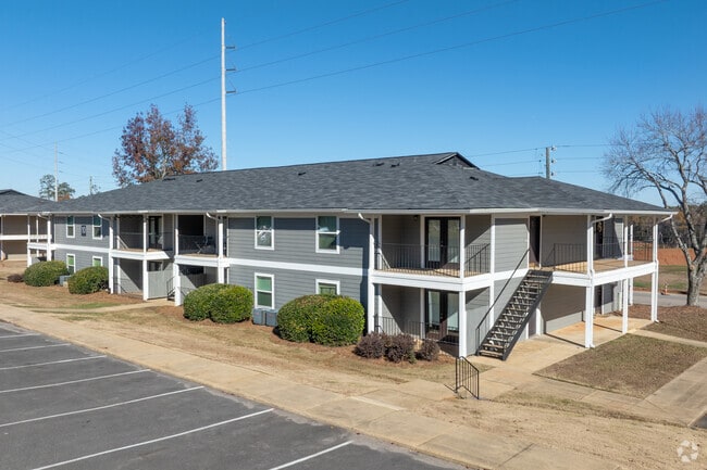

Property Detail
1449 Richland Rd
08-06-23-0-000-001.002
PART SEC 23 T19N R25E: COM INT S LINE & W ROW SHUG JORDAN PKWY; N 150'S TO BEG; W 130'; N 75'; W 150'; S 75'; W 520'; NW 1012
Officebuilding
Lee
B and X Area of moderate flood hazard, usually the area between the limits of the 100-year and 500-year floods.
Alabama
2025
14.75 AC
2025
North Auburn
040602
Columbus GA
2,009 SF
Auburn-Opelika, AL
NEARBY LISTINGS FOR SALE OR LEASE
DEMOGRAPHICS near 1449 Richland Rd
1 mile
3 mile
5 mile
2025 Total Population
7,220
51,893
84,086
2030 Population
7,700
55,263
89,756
Pop Growth 2025-2030
+ 6.65%
+ 6.49%
+ 6.74%
Average Age
30
31
33
2025 Total Households
2,846
21,172
34,156
HH Growth 2025-2030
+ 7.27%
+ 7.14%
+ 7.30%
Median Household Inc
$24,174
$37,594
$48,463
Avg Household Size
2.30
2.20
2.30
2025 Avg HH Vehicles
2.00
2.00
2.00
Median Home Value
$367,633
$333,389
$350,102
Median Year Built
2000
1996
1999
Nearby Places
Map Layers
Map Styles
 Street
 Aerial
Layers
 Traffic
 Biking
Places
Listings with unknown addresses are not visible on the map
- Restaurants
- Banks
- Shops
- Fitness
- Groceries
PUBLIC TRANSPORTATION
AIRPORT
Columbus
Drive
Walk
Distance
Columbus
58 min
41.1 mi
Nearby Properties
Address
Land Use
TOTAL SIZE
Lot Size
Zoning
Address
Land Use
TOTAL SIZE
Lot Size
Zoning
257,779 SF
1.57 AC
Address
Land Use
TOTAL SIZE
Lot Size
Zoning
1,724 SF
3.47 AC
Address
Land Use
TOTAL SIZE
Lot Size
Zoning
330,891 SF
3.45 AC
Address
Land Use
TOTAL SIZE
Lot Size
Zoning
357,901 SF
3.47 AC
Address
Land Use
TOTAL SIZE
Lot Size
Zoning
328,847 SF
3.27 AC
Address
Land Use
TOTAL SIZE
Lot Size
Zoning
Address
Land Use
TOTAL SIZE
Lot Size
Zoning
557,207 SF
2.45 AC
Address
Land Use
TOTAL SIZE
Lot Size
Zoning
176,021 SF
1.39 AC
Address
Land Use
TOTAL SIZE
Lot Size
Zoning
11,250 SF
11.34 AC
Address
Land Use
TOTAL SIZE
Lot Size
Zoning
219,562 SF
2.86 AC
Address
Land Use
TOTAL SIZE
Lot Size
Zoning
271,018 SF
5.54 AC
Address
Land Use
TOTAL SIZE
Lot Size
Zoning
160,743 SF
Address
Land Use
TOTAL SIZE
Lot Size
Zoning
123,827 SF
0.74 AC
Address
Land Use
TOTAL SIZE
Lot Size
Zoning
247,676 SF
1.57 AC
Address
Land Use
TOTAL SIZE
Lot Size
Zoning
17,691 SF
22.11 AC
Address
Land Use
TOTAL SIZE
Lot Size
Zoning
19,766 SF
12.22 AC
Address
Land Use
TOTAL SIZE
Lot Size
Zoning
15,876 SF
30.47 AC
Address
Land Use
TOTAL SIZE
Lot Size
Zoning
968 SF
4.36 AC
Address
Land Use
TOTAL SIZE
Lot Size
Zoning
17,684 SF
10 AC
Address
Land Use
TOTAL SIZE
Lot Size
Zoning
77,104 SF
5.42 AC
Address
Land Use
TOTAL SIZE
Lot Size
Zoning
7,700 SF
13.75 AC
Address
Land Use
TOTAL SIZE
Lot Size
Zoning
22,683 SF
7 AC
Address
Land Use
TOTAL SIZE
Lot Size
Zoning
0.88 AC
Address
Land Use
TOTAL SIZE
Lot Size
Zoning
1.71 AC
Address
Land Use
TOTAL SIZE
Lot Size
Zoning
26,784 SF
27.12 AC
Address
Land Use
TOTAL SIZE
Lot Size
Zoning
3,584 SF
5 AC
Address
Land Use
TOTAL SIZE
Lot Size
Zoning
1.69 AC
Address
Land Use
TOTAL SIZE
Lot Size
Zoning
13,224 SF
19.62 AC
Address
Land Use
TOTAL SIZE
Lot Size
Zoning
5,994 SF
6.59 AC
Address
Land Use
TOTAL SIZE
Lot Size
Zoning
4,945 SF
8.40 AC
The World's #1 Commercial Real Estate Marketplace
Connect with us
© 2026 CoStar Group
The information above has been obtained from sources believed reliable. While we do not doubt its accuracy we have not verified it and make no guarantee, warranty or representation about it. It is your responsibility to independently confirm its accuracy and completeness. Any projections, opinions, assumptions, or estimates used are for example only and do not represent the current or future performance of the property. The value of this transaction to you depends on tax and other factors which should be evaluated by your tax, financial, and legal advisors. You and your advisors should conduct a careful, independent investigation of the property to determine to your satisfaction the suitability of the property for your needs.