Property Record
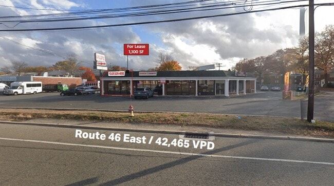
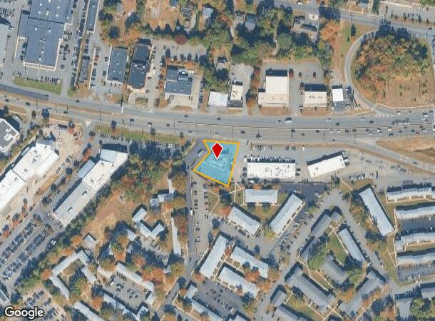
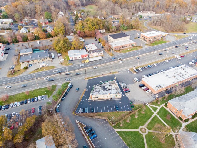
145 Route 46, Parsippany, NJ 07054
Current Lease Availabilities
NEARBY LISTINGS FOR SALE OR LEASE
Property Detail
145 Route 46
29-00767-0000-00006
ADDITIONAL LOTS: 152 17-F
Commercialnec
Morris
X
New Jersey
34027C0326F
6
2024
0.46 AC
2025
Parsippany
041803
Northern New Jersey
4,160 SF
Newark, NJ-PA
DEMOGRAPHICS near 145 Route 46
1 Mile
3 Mile
5 Mile
2024 Total Population
2,874
48,650
150,270
2029 Population
2,848
48,510
149,756
Pop Growth 2024-2029
(0.90%)
(0.29%)
(0.34%)
Average Age
40
42
43
2024 Total Households
1,256
18,289
55,280
HH Growth 2024-2029
(1.04%)
(0.24%)
(0.40%)
Median Household Inc
$93,230
$113,404
$121,585
Avg Household Size
2.30
2.60
2.60
2024 Avg HH Vehicles
2.00
2.00
2.00
Median Home Value
$679,766
$595,259
$612,679
Median Year Built
1969
1970
1967
Nearby Places
- Restaurants
- Banks
- Shops
- Fitness
- Groceries
PUBLIC TRANSPORTATION
COMMUTER RAIL
Towaco (Montclair-Boonton Line - NJ Transit Commuter Rail (NJ Transit))
DRIVE
WALK
Distance
Towaco (Montclair-Boonton Line - NJ Transit Commuter Rail (NJ Transit))
12 min
6.4 mi
Boonton (Montclair-Boonton Line - NJ Transit Commuter Rail (NJ Transit))
DRIVE
WALK
Distance
Boonton (Montclair-Boonton Line - NJ Transit Commuter Rail (NJ Transit))
9 min
6.8 mi
AIRPORT
Newark Liberty International
DRIVE
WALK
Distance
Newark Liberty International
29 min
20.2 mi
LaGuardia
DRIVE
WALK
Distance
LaGuardia
48 min
35.6 mi
Freight Ports
Maher Terminal
DRIVE
WALK
Distance
Maher Terminal
32 min
20.4 mi
Nearby Properties
Address
Land Use
TOTAL SIZE
Lot Size
Zoning
Address
Land Use
TOTAL SIZE
Lot Size
Zoning
48.85 AC
R-3B
Address
Land Use
TOTAL SIZE
Lot Size
Zoning
98.27 AC
AH1
Address
Land Use
TOTAL SIZE
Lot Size
Zoning
0.87 AC
R-5
Address
Land Use
TOTAL SIZE
Lot Size
Zoning
147,871 SF
26.50 AC
PB-3
Address
Land Use
TOTAL SIZE
Lot Size
Zoning
11,353 SF
9.29 AC
COD
Address
Land Use
TOTAL SIZE
Lot Size
Zoning
119,552 SF
129 AC
I1A
Address
Land Use
TOTAL SIZE
Lot Size
Zoning
3.86 AC
O-3
Address
Land Use
TOTAL SIZE
Lot Size
Zoning
32.61 AC
R-5
Address
Land Use
TOTAL SIZE
Lot Size
Zoning
17.90 AC
B-2
Address
Land Use
TOTAL SIZE
Lot Size
Zoning
336,832 SF
46.12 AC
R-L
Address
Land Use
TOTAL SIZE
Lot Size
Zoning
201,648 SF
19.35 AC
B-1
Address
Land Use
TOTAL SIZE
Lot Size
Zoning
27.50 AC
M-2
Address
Land Use
TOTAL SIZE
Lot Size
Zoning
197,023 SF
22.08 AC
AHMU
Address
Land Use
TOTAL SIZE
Lot Size
Zoning
91,872 SF
31.16 AC
B-1
Address
Land Use
TOTAL SIZE
Lot Size
Zoning
28.06 AC
OB-3
Address
Land Use
TOTAL SIZE
Lot Size
Zoning
259,325 SF
13.62 AC
I1A
Address
Land Use
TOTAL SIZE
Lot Size
Zoning
140,560 SF
49.81 AC
R27A
Address
Land Use
TOTAL SIZE
Lot Size
Zoning
598 SF
68.65 AC
HDL1
Address
Land Use
TOTAL SIZE
Lot Size
Zoning
143,548 SF
16.25 AC
M-2
Address
Land Use
TOTAL SIZE
Lot Size
Zoning
19.88 AC
I-3
Address
Land Use
TOTAL SIZE
Lot Size
Zoning
10.80 AC
R-5
Address
Land Use
TOTAL SIZE
Lot Size
Zoning
4.99 AC
OB
Address
Land Use
TOTAL SIZE
Lot Size
Zoning
13.20 AC
OB-3
Address
Land Use
TOTAL SIZE
Lot Size
Zoning
251,480 SF
36.14 AC
I1A
Address
Land Use
TOTAL SIZE
Lot Size
Zoning
147,540 SF
15.72 AC
M-2
Address
Land Use
TOTAL SIZE
Lot Size
Zoning
11.72 AC
OB-3
Address
Land Use
TOTAL SIZE
Lot Size
Zoning
4.02 AC
R-3
Address
Land Use
TOTAL SIZE
Lot Size
Zoning
14.99 AC
M-2
Address
Land Use
TOTAL SIZE
Lot Size
Zoning
8,910 SF
20.68 AC
L-1
Address
Land Use
TOTAL SIZE
Lot Size
Zoning
11.52 AC
R-5
The World's #1 Commercial Real Estate Marketplace
Connect with us
© 2025 CoStar Group
The information above has been obtained from sources believed reliable. While we do not doubt its accuracy we have not verified it and make no guarantee, warranty or representation about it. It is your responsibility to independently confirm its accuracy and completeness. Any projections, opinions, assumptions, or estimates used are for example only and do not represent the current or future performance of the property. The value of this transaction to you depends on tax and other factors which should be evaluated by your tax, financial, and legal advisors. You and your advisors should conduct a careful, independent investigation of the property to determine to your satisfaction the suitability of the property for your needs.