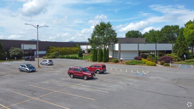
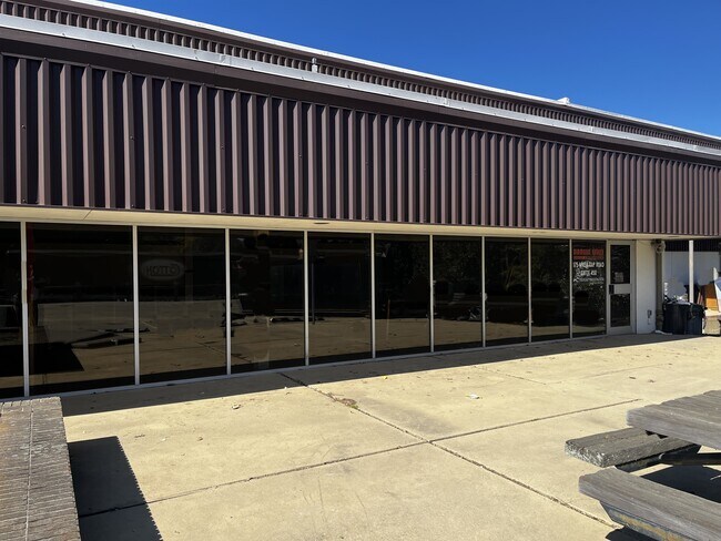
Property Record
145 Cane Creek Industrial Park Rd, Fletcher, NC 28732

Current Lease Availabilities
NEARBY LISTINGS FOR SALE OR LEASE
Property Detail
145 Cane Creek Industrial Park Rd
Asheville, NC
Cane Cr\Indust.Pk
1006235
LOT # STEELCASE INC
Industrialgeneral
Henderson
AE
North Carolina
3700966300K
6668
2025
46.99 AC
2025
Henderson County
930502
Asheville
899,676 SF
DEMOGRAPHICS near 145 Cane Creek Industrial Park Rd
1 Mile
3 Mile
5 Mile
2024 Total Population
1,776
21,508
49,772
2029 Population
1,863
22,235
51,641
Pop Growth 2024-2029
+ 4.90%
+ 3.38%
+ 3.76%
Average Age
42
42
42
2024 Total Households
745
8,963
20,809
HH Growth 2024-2029
+ 4.97%
+ 3.22%
+ 3.52%
Median Household Inc
$57,765
$70,068
$67,985
Avg Household Size
2.30
2.40
2.30
2024 Avg HH Vehicles
2.00
2.00
2.00
Median Home Value
$267,800
$308,116
$325,336
Median Year Built
2003
1993
1993
Nearby Places
Map Layers
Map Styles
 Street
 Aerial
- Restaurants
- Banks
- Shops
- Fitness
- Groceries
PUBLIC TRANSPORTATION
AIRPORT
Asheville Regional
DRIVE
WALK
Distance
Asheville Regional
12 min
5.8 mi
Freight Ports
North Charleston Terminal
DRIVE
WALK
Distance
North Charleston Terminal
278 min
245.5 mi
Nearby Properties
Address
Land Use
TOTAL SIZE
Lot Size
Zoning
Address
Land Use
TOTAL SIZE
Lot Size
Zoning
85,103 SF
11.69 AC
RES EXP
Address
Land Use
TOTAL SIZE
Lot Size
Zoning
207,701 SF
458.72 AC
R-3
Address
Land Use
TOTAL SIZE
Lot Size
Zoning
73,420 SF
10.24 AC
RM16
Address
Land Use
TOTAL SIZE
Lot Size
Zoning
481,731 SF
86.32 AC
1009658~I
Address
Land Use
TOTAL SIZE
Lot Size
Zoning
3,466 SF
11.32 AC
10000832~M
Address
Land Use
TOTAL SIZE
Lot Size
Zoning
4,839 SF
9.46 AC
10002512~C
Address
Land Use
TOTAL SIZE
Lot Size
Zoning
92,772 SF
12.30 AC
R-2
Address
Land Use
TOTAL SIZE
Lot Size
Zoning
43,882 SF
9.71 AC
1016337~C1
Address
Land Use
TOTAL SIZE
Lot Size
Zoning
24.83 AC
1012291~M-
Address
Land Use
TOTAL SIZE
Lot Size
Zoning
87,220 SF
39.11 AC
PS
Address
Land Use
TOTAL SIZE
Lot Size
Zoning
107,698 SF
25.53 AC
PS
Address
Land Use
TOTAL SIZE
Lot Size
Zoning
208,715 SF
33.50 AC
CI
Address
Land Use
TOTAL SIZE
Lot Size
Zoning
41,104 SF
5.45 AC
CR
Address
Land Use
TOTAL SIZE
Lot Size
Zoning
76,255 SF
10.55 AC
EMP
Address
Land Use
TOTAL SIZE
Lot Size
Zoning
415,861 SF
59.02 AC
9927651~M-
Address
Land Use
TOTAL SIZE
Lot Size
Zoning
13,525 SF
1.84 AC
LODG EXP
Address
Land Use
TOTAL SIZE
Lot Size
Zoning
15,493 SF
2.01 AC
EMP
Address
Land Use
TOTAL SIZE
Lot Size
Zoning
28,183 SF
5.88 AC
10010086~C
Address
Land Use
TOTAL SIZE
Lot Size
Zoning
82,096 SF
19.67 AC
1015839~R1
Address
Land Use
TOTAL SIZE
Lot Size
Zoning
51,090 SF
5.18 AC
1007612~C-
Address
Land Use
TOTAL SIZE
Lot Size
Zoning
43,030 SF
5.15 AC
1016338~C1
Address
Land Use
TOTAL SIZE
Lot Size
Zoning
71,973 SF
6.71 AC
HB
Address
Land Use
TOTAL SIZE
Lot Size
Zoning
404,414 SF
27.75 AC
IND
Address
Land Use
TOTAL SIZE
Lot Size
Zoning
57,827 SF
1.68 AC
1017417~C-
Address
Land Use
TOTAL SIZE
Lot Size
Zoning
355,552 SF
40.75 AC
EMP
Address
Land Use
TOTAL SIZE
Lot Size
Zoning
39,080 SF
71.04 AC
1001876~R1
Address
Land Use
TOTAL SIZE
Lot Size
Zoning
1,575 SF
18.75 AC
10002245~C
Address
Land Use
TOTAL SIZE
Lot Size
Zoning
56,273 SF
2.43 AC
1000215~C-
Address
Land Use
TOTAL SIZE
Lot Size
Zoning
54,875 SF
2.02 AC
1006760~C-
The World's #1 Commercial Real Estate Marketplace
Connect with us
© 2026 CoStar Group
The information above has been obtained from sources believed reliable. While we do not doubt its accuracy we have not verified it and make no guarantee, warranty or representation about it. It is your responsibility to independently confirm its accuracy and completeness. Any projections, opinions, assumptions, or estimates used are for example only and do not represent the current or future performance of the property. The value of this transaction to you depends on tax and other factors which should be evaluated by your tax, financial, and legal advisors. You and your advisors should conduct a careful, independent investigation of the property to determine to your satisfaction the suitability of the property for your needs.