Property Record
145 Columbus Blvd, New Britain, CT 06051

Save to a Folder
{{folder.Name}}
{{folder.ListingIds.length}} Properties
{{folder.ListingIds.length}} Property
Create a New Folder
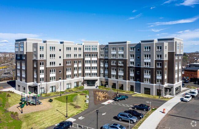
Property Detail
145 Columbus Blvd
Commercialbuilding
Capitol
CBD
Connecticut
B and X Area of moderate flood hazard, usually the area between the limits of the 100-year and 500-year floods.
1.41 AC
2025
New Britain/Newington/Wethersfield
2025
Hartford
417100
Hartford-West Hartford-East Hartford, CT
112,637 SF
C8A 910
NEARBY LISTINGS FOR SALE OR LEASE
DEMOGRAPHICS near 145 Columbus Blvd
1 mile
3 mile
5 mile
2025 Total Population
26,907
87,995
160,758
2030 Population
27,091
88,709
162,766
Pop Growth 2025-2030
+ 0.68%
+ 0.81%
+ 1.25%
Average Age
37
39
41
2025 Total Households
10,978
34,560
65,135
HH Growth 2025-2030
+ 0.81%
+ 0.85%
+ 1.29%
Median Household Inc
$42,771
$62,150
$80,714
Avg Household Size
2.30
2.40
2.40
2025 Avg HH Vehicles
1.00
2.00
2.00
Median Home Value
$221,452
$254,158
$297,692
Median Year Built
1948
1956
1962
Nearby Places
Map Layers
Map Styles
 Street
 Aerial
Layers
 Traffic
 Biking
Places
Listings with unknown addresses are not visible on the map
- Restaurants
- Banks
- Shops
- Fitness
- Groceries
PUBLIC TRANSPORTATION
COMMUTER RAIL
Drive
Walk
Distance
6 min
2.8 mi
Drive
Walk
Distance
6 min
2.8 mi
AIRPORT
Bradley International
Drive
Walk
Distance
Bradley International
48 min
28.8 mi
Tweed/New Haven
Drive
Walk
Distance
Tweed/New Haven
47 min
33.2 mi
SALE & LEASE HISTORY
LISTING DATE
SALE/LEASE

Oct 01, 2019
For Lease
Jan 18, 2023
For Lease
Nearby Properties
Address
Land Use
TOTAL SIZE
Lot Size
Zoning
Address
Land Use
TOTAL SIZE
Lot Size
Zoning
146,740 SF
18.23 AC
TPC
Address
Land Use
TOTAL SIZE
Lot Size
Zoning
109,079 SF
110.62 AC
OT
Address
Land Use
TOTAL SIZE
Lot Size
Zoning
23.64 AC
S3
Address
Land Use
TOTAL SIZE
Lot Size
Zoning
131.09 AC
OP
Address
Land Use
TOTAL SIZE
Lot Size
Zoning
19.60 AC
S2
Address
Land Use
TOTAL SIZE
Lot Size
Zoning
138.27 AC
S1
Address
Land Use
TOTAL SIZE
Lot Size
Zoning
64,822 SF
9.47 AC
TP
Address
Land Use
TOTAL SIZE
Lot Size
Zoning
155,161 SF
18.18 AC
S1
Address
Land Use
TOTAL SIZE
Lot Size
Zoning
2.07 AC
CBD
Address
Land Use
TOTAL SIZE
Lot Size
Zoning
117,139 SF
6.77 AC
T
Address
Land Use
TOTAL SIZE
Lot Size
Zoning
90,625 SF
0.97 AC
CBD
Address
Land Use
TOTAL SIZE
Lot Size
Zoning
96,238 SF
6.75 AC
T
Address
Land Use
TOTAL SIZE
Lot Size
Zoning
2.46 AC
CBD
Address
Land Use
TOTAL SIZE
Lot Size
Zoning
13.34 AC
PD
Address
Land Use
TOTAL SIZE
Lot Size
Zoning
33.36 AC
T
Address
Land Use
TOTAL SIZE
Lot Size
Zoning
78,109 SF
8.22 AC
T
Address
Land Use
TOTAL SIZE
Lot Size
Zoning
112,304 SF
10.39 AC
S3
Address
Land Use
TOTAL SIZE
Lot Size
Zoning
14,364 SF
2.72 AC
S3
Address
Land Use
TOTAL SIZE
Lot Size
Zoning
89,544 SF
6.20 AC
S1
Address
Land Use
TOTAL SIZE
Lot Size
Zoning
21.35 AC
PD
Address
Land Use
TOTAL SIZE
Lot Size
Zoning
68 AC
R-20
Address
Land Use
TOTAL SIZE
Lot Size
Zoning
18.40 AC
PD
Address
Land Use
TOTAL SIZE
Lot Size
Zoning
74,670 SF
4.46 AC
S2
Address
Land Use
TOTAL SIZE
Lot Size
Zoning
78,132 SF
11.76 AC
S2
Address
Land Use
TOTAL SIZE
Lot Size
Zoning
5.20 AC
PD
Address
Land Use
TOTAL SIZE
Lot Size
Zoning
38,860 SF
38.47 AC
PS-B
Address
Land Use
TOTAL SIZE
Lot Size
Zoning
83,464 SF
13.96 AC
T
Address
Land Use
TOTAL SIZE
Lot Size
Zoning
185,902 SF
101.89 AC
GI-2
Address
Land Use
TOTAL SIZE
Lot Size
Zoning
16.29 AC
PD
Address
Land Use
TOTAL SIZE
Lot Size
Zoning
3,380 SF
20.36 AC
A1
The World's #1 Commercial Real Estate Marketplace
Connect with us
© 2026 CoStar Group
The information above has been obtained from sources believed reliable. While we do not doubt its accuracy we have not verified it and make no guarantee, warranty or representation about it. It is your responsibility to independently confirm its accuracy and completeness. Any projections, opinions, assumptions, or estimates used are for example only and do not represent the current or future performance of the property. The value of this transaction to you depends on tax and other factors which should be evaluated by your tax, financial, and legal advisors. You and your advisors should conduct a careful, independent investigation of the property to determine to your satisfaction the suitability of the property for your needs.