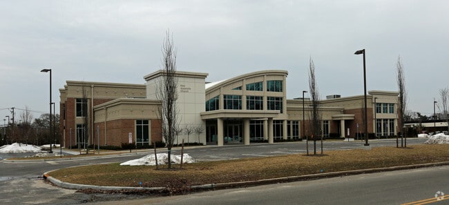
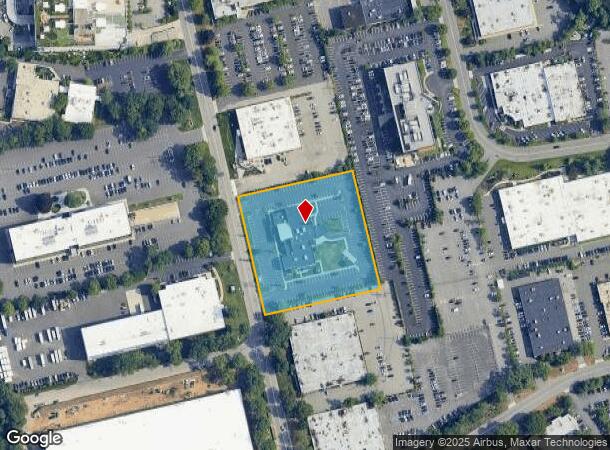
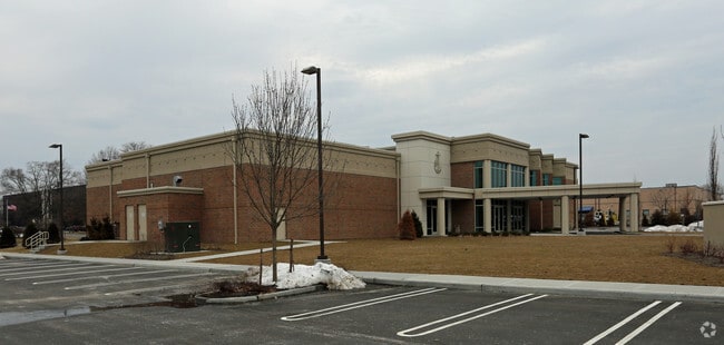
Property Record
145 Crossways Park Dr W, Woodbury, NY 11797
NEARBY LISTINGS FOR SALE OR LEASE
Property Detail
145 Crossways Park Dr W
2489-15-183-00-0063-0
TOWN #3 SCH DIST 013
Religious
Nassau
X
New York
36103C0615H
63
0
2.84 AC
2025
Eastern Nassau
518204
Long Island (New York)
25,609 SF
Nassau County-Suffolk County, NY
DEMOGRAPHICS near 145 Crossways Park Dr W
1 Mile
3 Mile
5 Mile
2024 Total Population
12,491
86,494
209,194
2029 Population
12,403
85,385
205,730
Pop Growth 2024-2029
(0.70%)
(1.28%)
(1.66%)
Average Age
44
43
42
2024 Total Households
4,277
27,959
67,477
HH Growth 2024-2029
(0.77%)
(1.39%)
(1.74%)
Median Household Inc
$161,418
$160,916
$140,901
Avg Household Size
2.80
3.00
2.90
2024 Avg HH Vehicles
2.00
2.00
2.00
Median Home Value
$769,913
$777,887
$724,075
Median Year Built
1970
1958
1958
Nearby Places
- Restaurants
- Banks
- Shops
- Fitness
- Groceries
PUBLIC TRANSPORTATION
COMMUTER RAIL
Syosset Station (Port Jefferson Branch - Long Island Rail Road)
DRIVE
WALK
Distance
Syosset Station (Port Jefferson Branch - Long Island Rail Road)
6 min
2.4 mi
Cold Spring Harbor Station (Port Jefferson Branch - Long Island Rail Road)
DRIVE
WALK
Distance
Cold Spring Harbor Station (Port Jefferson Branch - Long Island Rail Road)
9 min
3.5 mi
AIRPORT
John F Kennedy International
DRIVE
WALK
Distance
John F Kennedy International
39 min
23.7 mi
LaGuardia
DRIVE
WALK
Distance
LaGuardia
37 min
24.1 mi
Long Island MacArthur
DRIVE
WALK
Distance
Long Island MacArthur
37 min
24.3 mi
Freight Ports
NY - Red Hook Container Terminal
DRIVE
WALK
Distance
NY - Red Hook Container Terminal
49 min
32.2 mi
Nearby Properties
Address
Land Use
TOTAL SIZE
Lot Size
Zoning
Address
Land Use
TOTAL SIZE
Lot Size
Zoning
Address
Land Use
TOTAL SIZE
Lot Size
Zoning
Address
Land Use
TOTAL SIZE
Lot Size
Zoning
Address
Land Use
TOTAL SIZE
Lot Size
Zoning
6.30 AC
Address
Land Use
TOTAL SIZE
Lot Size
Zoning
Address
Land Use
TOTAL SIZE
Lot Size
Zoning
178,486 SF
53.25 AC
Address
Land Use
TOTAL SIZE
Lot Size
Zoning
469,586 SF
53.14 AC
Address
Land Use
TOTAL SIZE
Lot Size
Zoning
647,177 SF
51.88 AC
Address
Land Use
TOTAL SIZE
Lot Size
Zoning
300,526 SF
44.30 AC
Address
Land Use
TOTAL SIZE
Lot Size
Zoning
160 SF
241.23 AC
Address
Land Use
TOTAL SIZE
Lot Size
Zoning
Address
Land Use
TOTAL SIZE
Lot Size
Zoning
2,555 SF
284.67 AC
Address
Land Use
TOTAL SIZE
Lot Size
Zoning
Address
Land Use
TOTAL SIZE
Lot Size
Zoning
Address
Land Use
TOTAL SIZE
Lot Size
Zoning
332,290 SF
25.91 AC
Address
Land Use
TOTAL SIZE
Lot Size
Zoning
29,574 SF
174.23 AC
Address
Land Use
TOTAL SIZE
Lot Size
Zoning
146,287 SF
48.63 AC
Address
Land Use
TOTAL SIZE
Lot Size
Zoning
77,284 SF
40.86 AC
Address
Land Use
TOTAL SIZE
Lot Size
Zoning
159,471 SF
28.50 AC
Address
Land Use
TOTAL SIZE
Lot Size
Zoning
2.92 AC
R20
Address
Land Use
TOTAL SIZE
Lot Size
Zoning
Address
Land Use
TOTAL SIZE
Lot Size
Zoning
34,500 SF
16 AC
Address
Land Use
TOTAL SIZE
Lot Size
Zoning
84,714 SF
15.09 AC
Address
Land Use
TOTAL SIZE
Lot Size
Zoning
220,367 SF
24 AC
Address
Land Use
TOTAL SIZE
Lot Size
Zoning
177,109 SF
23.78 AC
Address
Land Use
TOTAL SIZE
Lot Size
Zoning
228,527 SF
4.81 AC
Address
Land Use
TOTAL SIZE
Lot Size
Zoning
Address
Land Use
TOTAL SIZE
Lot Size
Zoning
28,537 SF
5.21 AC
Address
Land Use
TOTAL SIZE
Lot Size
Zoning
348,861 SF
2.22 AC
Address
Land Use
TOTAL SIZE
Lot Size
Zoning
204,726 SF
28.34 AC
The World's #1 Commercial Real Estate Marketplace
Connect with us
© 2025 CoStar Group
The information above has been obtained from sources believed reliable. While we do not doubt its accuracy we have not verified it and make no guarantee, warranty or representation about it. It is your responsibility to independently confirm its accuracy and completeness. Any projections, opinions, assumptions, or estimates used are for example only and do not represent the current or future performance of the property. The value of this transaction to you depends on tax and other factors which should be evaluated by your tax, financial, and legal advisors. You and your advisors should conduct a careful, independent investigation of the property to determine to your satisfaction the suitability of the property for your needs.