Property Record
145 E Main St, Smithtown, NY 11787


Save to a Folder
{{folder.Name}}
{{folder.ListingIds.length}} Properties
{{folder.ListingIds.length}} Property
Create a New Folder
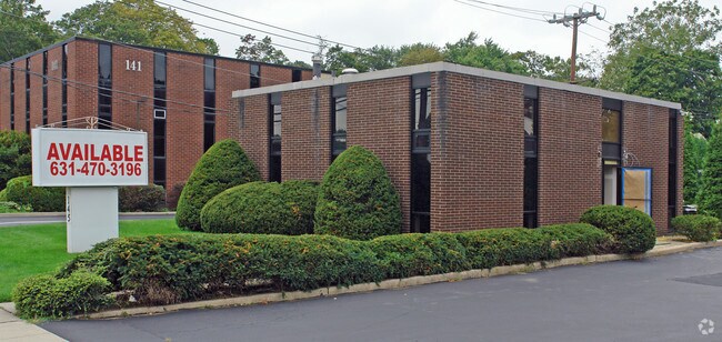
Property Detail
145 E Main St
Nassau County-Suffolk County, NY
BLK LOT
0400-029-00-03-00-039-000
Suffolk
Officebuilding
New York
C3
39
B and X Area of moderate flood hazard, usually the area between the limits of the 100-year and 500-year floods.
0.22 AC
2024
Western Suffolk
2025
Long Island (New York)
134908
NEARBY LISTINGS FOR SALE OR LEASE
DEMOGRAPHICS near 145 E Main St
1 mile
3 mile
5 mile
2025 Total Population
6,199
66,123
138,503
2030 Population
6,130
65,221
136,758
Pop Growth 2025-2030
(1.11%)
(1.36%)
(1.26%)
Average Age
45
42
43
2025 Total Households
2,357
22,767
47,250
HH Growth 2025-2030
(1.53%)
(1.55%)
(1.52%)
Median Household Inc
$163,816
$155,087
$156,443
Avg Household Size
2.60
2.80
2.80
2025 Avg HH Vehicles
2.00
2.00
2.00
Median Home Value
$782,101
$765,165
$760,059
Median Year Built
1955
1957
1958
Nearby Places
Map Layers
Map Styles
 Street
 Aerial
Layers
 Traffic
 Biking
Places
Listings with unknown addresses are not visible on the map
- Restaurants
- Banks
- Shops
- Fitness
- Groceries
PUBLIC TRANSPORTATION
COMMUTER RAIL
Smithtown (Port Jefferson Branch - Long Island Rail Road)
Drive
Walk
Distance
Smithtown (Port Jefferson Branch - Long Island Rail Road)
1 min
13 min
0.6 mi
St. James (Port Jefferson Branch - Long Island Rail Road)
Drive
Walk
Distance
St. James (Port Jefferson Branch - Long Island Rail Road)
5 min
3.1 mi
AIRPORT
Long Island MacArthur
Drive
Walk
Distance
Long Island MacArthur
17 min
9.9 mi
Freight Ports
Port of New Haven
Drive
Walk
Distance
Port of New Haven
124 min
48.7 mi
Nearby Properties
Address
Land Use
TOTAL SIZE
Lot Size
Zoning
Address
Land Use
TOTAL SIZE
Lot Size
Zoning
97.50 AC
AAA
Address
Land Use
TOTAL SIZE
Lot Size
Zoning
57.30 AC
AAA
Address
Land Use
TOTAL SIZE
Lot Size
Zoning
24.96 AC
Address
Land Use
TOTAL SIZE
Lot Size
Zoning
5.32 AC
BUS3
Address
Land Use
TOTAL SIZE
Lot Size
Zoning
24.70 AC
AAA
Address
Land Use
TOTAL SIZE
Lot Size
Zoning
13.06 AC
BUS3
Address
Land Use
TOTAL SIZE
Lot Size
Zoning
12.80 AC
AAA
Address
Land Use
TOTAL SIZE
Lot Size
Zoning
8.35 AC
IND1
Address
Land Use
TOTAL SIZE
Lot Size
Zoning
9.90 AC
CA
Address
Land Use
TOTAL SIZE
Lot Size
Zoning
10.30 AC
CA
Address
Land Use
TOTAL SIZE
Lot Size
Zoning
6.48 AC
CA
Address
Land Use
TOTAL SIZE
Lot Size
Zoning
4.52 AC
CA
Address
Land Use
TOTAL SIZE
Lot Size
Zoning
60.30 AC
Address
Land Use
TOTAL SIZE
Lot Size
Zoning
4.60 AC
GSE
Address
Land Use
TOTAL SIZE
Lot Size
Zoning
0.28 AC
VILLA
Address
Land Use
TOTAL SIZE
Lot Size
Zoning
4.91 AC
AAA
Address
Land Use
TOTAL SIZE
Lot Size
Zoning
35.70 AC
Address
Land Use
TOTAL SIZE
Lot Size
Zoning
7.86 AC
BUS2
Address
Land Use
TOTAL SIZE
Lot Size
Zoning
14.50 AC
Address
Land Use
TOTAL SIZE
Lot Size
Zoning
2,096 SF
1.32 AC
R40
Address
Land Use
TOTAL SIZE
Lot Size
Zoning
3.81 AC
BUS2
Address
Land Use
TOTAL SIZE
Lot Size
Zoning
4.80 AC
CA
Address
Land Use
TOTAL SIZE
Lot Size
Zoning
2.82 AC
IND1
Address
Land Use
TOTAL SIZE
Lot Size
Zoning
18.20 AC
Address
Land Use
TOTAL SIZE
Lot Size
Zoning
3.13 AC
Address
Land Use
TOTAL SIZE
Lot Size
Zoning
35.49 AC
AAA
Address
Land Use
TOTAL SIZE
Lot Size
Zoning
3.73 AC
BUS2
Address
Land Use
TOTAL SIZE
Lot Size
Zoning
3.48 AC
BUS1
Address
Land Use
TOTAL SIZE
Lot Size
Zoning
128.70 AC
AA278
Address
Land Use
TOTAL SIZE
Lot Size
Zoning
2.72 AC
IND1
The World's #1 Commercial Real Estate Marketplace
Connect with us
© 2026 CoStar Group
The information above has been obtained from sources believed reliable. While we do not doubt its accuracy we have not verified it and make no guarantee, warranty or representation about it. It is your responsibility to independently confirm its accuracy and completeness. Any projections, opinions, assumptions, or estimates used are for example only and do not represent the current or future performance of the property. The value of this transaction to you depends on tax and other factors which should be evaluated by your tax, financial, and legal advisors. You and your advisors should conduct a careful, independent investigation of the property to determine to your satisfaction the suitability of the property for your needs.