Property Record
145 Esmeralda Dr, Washoe Valley, NV 89704


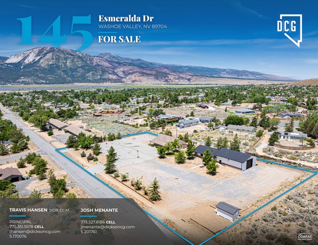
This Property Is For Sale
NEARBY LISTINGS FOR SALE OR LEASE
-
-
View all Washoe Valley listings for sale on LoopNet.com
Property Detail
145 Esmeralda Dr
050-411-32
_Reversion
Commercialnec
REV TM 3863
X
Washoe
32031C3350G
Nevada
0
2.13 AC
2026
S Outlying Washoe Cty
003207
Reno/Sparks
6,400 SF
Reno, NV
DEMOGRAPHICS near 145 Esmeralda Dr
1 Mile
3 Mile
5 Mile
2024 Total Population
2,332
3,177
5,673
2029 Population
2,450
3,335
6,012
Pop Growth 2024-2029
+ 5.06%
+ 4.97%
+ 5.98%
Average Age
48
48
48
2024 Total Households
946
1,292
2,271
HH Growth 2024-2029
+ 5.07%
+ 5.03%
+ 6.08%
Median Household Inc
$98,852
$96,936
$101,377
Avg Household Size
2.40
2.40
2.40
2024 Avg HH Vehicles
3.00
3.00
3.00
Median Home Value
$482,989
$485,051
$639,319
Median Year Built
1980
1979
1984
Nearby Places
Map Layers
Map Styles
 Street
 Aerial
- Restaurants
- Banks
- Shops
- Fitness
- Groceries
PUBLIC TRANSPORTATION
AIRPORT
Reno/Tahoe International
DRIVE
WALK
Distance
Reno/Tahoe International
47 min
21.3 mi
Freight Ports
Port of Stockton
DRIVE
WALK
Distance
Port of Stockton
238 min
200.6 mi
Nearby Properties
Address
Land Use
TOTAL SIZE
Lot Size
Zoning
Address
Land Use
TOTAL SIZE
Lot Size
Zoning
2,929.44 AC
PR 22%/WB
Address
Land Use
TOTAL SIZE
Lot Size
Zoning
15,402 SF
3 AC
PSP
Address
Land Use
TOTAL SIZE
Lot Size
Zoning
20,670 SF
52.58 AC
PSP
Address
Land Use
TOTAL SIZE
Lot Size
Zoning
9,100 SF
1.22 AC
GC
Address
Land Use
TOTAL SIZE
Lot Size
Zoning
1,053.60 AC
OS 96% / G
Address
Land Use
TOTAL SIZE
Lot Size
Zoning
14.18 AC
PR
Address
Land Use
TOTAL SIZE
Lot Size
Zoning
17.65 AC
MDR
Address
Land Use
TOTAL SIZE
Lot Size
Zoning
640 AC
OS
Address
Land Use
TOTAL SIZE
Lot Size
Zoning
640 AC
OS
Address
Land Use
TOTAL SIZE
Lot Size
Zoning
640 AC
OS
Address
Land Use
TOTAL SIZE
Lot Size
Zoning
640 AC
OS
Address
Land Use
TOTAL SIZE
Lot Size
Zoning
620 AC
OS
Address
Land Use
TOTAL SIZE
Lot Size
Zoning
600 AC
OS
Address
Land Use
TOTAL SIZE
Lot Size
Zoning
3,000 SF
4.09 AC
PSP
Address
Land Use
TOTAL SIZE
Lot Size
Zoning
509.33 AC
OS
Address
Land Use
TOTAL SIZE
Lot Size
Zoning
5,918 SF
1 AC
GC
Address
Land Use
TOTAL SIZE
Lot Size
Zoning
7,200 SF
1.06 AC
GC
Address
Land Use
TOTAL SIZE
Lot Size
Zoning
480 AC
OS
Address
Land Use
TOTAL SIZE
Lot Size
Zoning
23.75 AC
GR
Address
Land Use
TOTAL SIZE
Lot Size
Zoning
9.52 AC
LDR
Address
Land Use
TOTAL SIZE
Lot Size
Zoning
Address
Land Use
TOTAL SIZE
Lot Size
Zoning
17.33 AC
GR
Address
Land Use
TOTAL SIZE
Lot Size
Zoning
417.03 AC
OS
Address
Land Use
TOTAL SIZE
Lot Size
Zoning
5,340 SF
1.17 AC
LDS
Address
Land Use
TOTAL SIZE
Lot Size
Zoning
5,340 SF
1 AC
LDS
Address
Land Use
TOTAL SIZE
Lot Size
Zoning
24.63 AC
HDR
Address
Land Use
TOTAL SIZE
Lot Size
Zoning
12,400 SF
1.13 AC
GC
Address
Land Use
TOTAL SIZE
Lot Size
Zoning
10,500 SF
0.97 AC
GC
Address
Land Use
TOTAL SIZE
Lot Size
Zoning
4.97 AC
HDR
The World's #1 Commercial Real Estate Marketplace
Connect with us
© 2026 CoStar Group
The information above has been obtained from sources believed reliable. While we do not doubt its accuracy we have not verified it and make no guarantee, warranty or representation about it. It is your responsibility to independently confirm its accuracy and completeness. Any projections, opinions, assumptions, or estimates used are for example only and do not represent the current or future performance of the property. The value of this transaction to you depends on tax and other factors which should be evaluated by your tax, financial, and legal advisors. You and your advisors should conduct a careful, independent investigation of the property to determine to your satisfaction the suitability of the property for your needs.