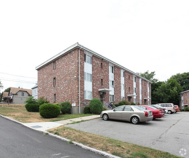
Property Record
145 Garfield Ave, New London, CT 06320
NEARBY LISTINGS FOR SALE OR LEASE
Property Detail
145 Garfield Ave
NLON-000030-000160-000019
New London
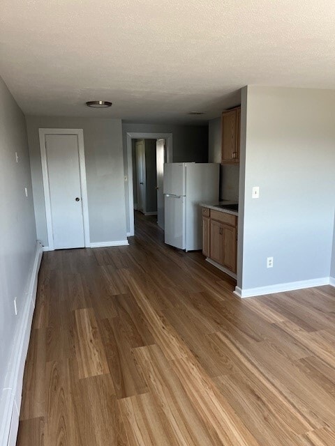
Apartmenthouse5plusunits
Connecticut
X
19
09011C0501J
0.94 AC
2025
New London
2025
Hartford
690300
Norwich-New London, CT
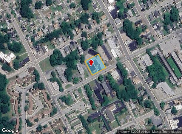
DEMOGRAPHICS near 145 Garfield Ave
1 Mile
3 Mile
5 Mile
2024 Total Population
16,359
53,188
77,860
2029 Population
16,267
53,084
77,894
Pop Growth 2024-2029
(0.56%)
(0.20%)
+ 0.04%
Average Age
38
39
40
2024 Total Households
6,749
21,663
32,208
HH Growth 2024-2029
(0.46%)
(0.15%)
+ 0.08%
Median Household Inc
$39,744
$63,663
$70,613
Avg Household Size
2.30
2.20
2.20
2024 Avg HH Vehicles
1.00
2.00
2.00
Median Home Value
$182,976
$247,792
$263,548
Median Year Built
1947
1962
1966
Nearby Places
Map Layers
Map Styles
 Street
 Aerial
- Restaurants
- Banks
- Shops
- Fitness
- Groceries
PUBLIC TRANSPORTATION
COMMUTER RAIL
New London (Shore Line East - Shore Line East)
DRIVE
WALK
Distance
New London (Shore Line East - Shore Line East)
3 min
1.5 mi
Freight Ports
Port of Davisville, RI
DRIVE
WALK
Distance
Port of Davisville, RI
70 min
52.2 mi
SALE & LEASE HISTORY
LISTING DATE
SALE/LEASE

Jul 22, 2025
For Sale
Nearby Properties
Address
Land Use
TOTAL SIZE
Lot Size
Zoning
Address
Land Use
TOTAL SIZE
Lot Size
Zoning
24.41 AC
WCI-2
Address
Land Use
TOTAL SIZE
Lot Size
Zoning
8,712 SF
RU-20
Address
Land Use
TOTAL SIZE
Lot Size
Zoning
45,582 SF
39.40 AC
WCI-1
Address
Land Use
TOTAL SIZE
Lot Size
Zoning
296,000 SF
46.82 AC
C-T
Address
Land Use
TOTAL SIZE
Lot Size
Zoning
49.32 AC
R-3
Address
Land Use
TOTAL SIZE
Lot Size
Zoning
28,764 SF
37.76 AC
RM
Address
Land Use
TOTAL SIZE
Lot Size
Zoning
59,264 SF
54.53 AC
I/T
Address
Land Use
TOTAL SIZE
Lot Size
Zoning
11,880 SF
35.66 AC
RM
Address
Land Use
TOTAL SIZE
Lot Size
Zoning
54.80 AC
INST
Address
Land Use
TOTAL SIZE
Lot Size
Zoning
13.68 AC
CR
Address
Land Use
TOTAL SIZE
Lot Size
Zoning
21.84 AC
C-2
Address
Land Use
TOTAL SIZE
Lot Size
Zoning
41.89 AC
SDD
Address
Land Use
TOTAL SIZE
Lot Size
Zoning
73,446 SF
69.87 AC
R-12
Address
Land Use
TOTAL SIZE
Lot Size
Zoning
178,385 SF
5.42 AC
LI-O
Address
Land Use
TOTAL SIZE
Lot Size
Zoning
12.03 AC
INST
Address
Land Use
TOTAL SIZE
Lot Size
Zoning
26.44 AC
C-G
Address
Land Use
TOTAL SIZE
Lot Size
Zoning
55,766 SF
1.33 AC
R-4
Address
Land Use
TOTAL SIZE
Lot Size
Zoning
68,774 SF
53.34 AC
C-T
Address
Land Use
TOTAL SIZE
Lot Size
Zoning
68,331 SF
9.50 AC
R-20
Address
Land Use
TOTAL SIZE
Lot Size
Zoning
79,535 SF
3.03 AC
R-2
Address
Land Use
TOTAL SIZE
Lot Size
Zoning
204,329 SF
17.92 AC
CR
Address
Land Use
TOTAL SIZE
Lot Size
Zoning
135,113 SF
2.51 AC
LI-O
Address
Land Use
TOTAL SIZE
Lot Size
Zoning
9.41 AC
R-4
Address
Land Use
TOTAL SIZE
Lot Size
Zoning
129,890 SF
40.95 AC
R-20
Address
Land Use
TOTAL SIZE
Lot Size
Zoning
75,441 SF
40.56 AC
R52
Address
Land Use
TOTAL SIZE
Lot Size
Zoning
5.65 AC
R-2
Address
Land Use
TOTAL SIZE
Lot Size
Zoning
33.50 AC
R-12
Address
Land Use
TOTAL SIZE
Lot Size
Zoning
4.31 AC
WCI-2
Address
Land Use
TOTAL SIZE
Lot Size
Zoning
56.50 AC
C-R
Address
Land Use
TOTAL SIZE
Lot Size
Zoning
18.95 AC
INST
The World's #1 Commercial Real Estate Marketplace
Connect with us
© 2026 CoStar Group
The information above has been obtained from sources believed reliable. While we do not doubt its accuracy we have not verified it and make no guarantee, warranty or representation about it. It is your responsibility to independently confirm its accuracy and completeness. Any projections, opinions, assumptions, or estimates used are for example only and do not represent the current or future performance of the property. The value of this transaction to you depends on tax and other factors which should be evaluated by your tax, financial, and legal advisors. You and your advisors should conduct a careful, independent investigation of the property to determine to your satisfaction the suitability of the property for your needs.