Property Record
145 Harmon Creek Rd, Kernersville, NC 27284
NEARBY LISTINGS FOR SALE OR LEASE
Property Detail
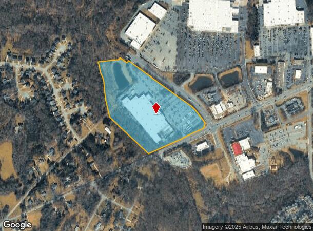
145 Harmon Creek Rd
Winston-Salem, NC
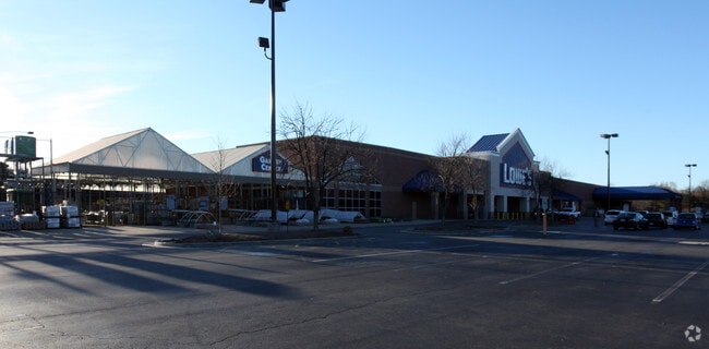
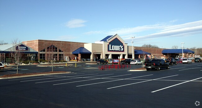
Lowes Home Center
6875-39-6603
LOWES HOME CENTER LO:000E BL:5351Y BU:1
Storebuilding
Forsyth
AE
North Carolina
3710687500J
e
2024
19.46 AC
2025
Kernersville
003307
Greensboro/Winston-Salem
832 SF
DEMOGRAPHICS near 145 Harmon Creek Rd
1 Mile
3 Mile
5 Mile
2024 Total Population
4,274
37,091
72,109
2029 Population
4,426
38,619
75,060
Pop Growth 2024-2029
+ 3.56%
+ 4.12%
+ 4.09%
Average Age
43
42
41
2024 Total Households
1,788
15,751
29,552
HH Growth 2024-2029
+ 3.41%
+ 4.10%
+ 4.11%
Median Household Inc
$84,034
$71,553
$69,352
Avg Household Size
2.40
2.30
2.40
2024 Avg HH Vehicles
2.00
2.00
2.00
Median Home Value
$272,656
$224,788
$219,461
Median Year Built
1988
1988
1989
Nearby Places
Map Layers
Map Styles
 Street
 Aerial
- Restaurants
- Banks
- Shops
- Fitness
- Groceries
PUBLIC TRANSPORTATION
AIRPORT
Piedmont Triad International
DRIVE
WALK
Distance
Piedmont Triad International
23 min
12.5 mi
Freight Ports
Virginia Port Authority - Richmond
DRIVE
WALK
Distance
Virginia Port Authority - Richmond
250 min
216.1 mi
Nearby Properties
Address
Land Use
TOTAL SIZE
Lot Size
Zoning
Address
Land Use
TOTAL SIZE
Lot Size
Zoning
122,848 SF
22.70 AC
RM18-S
Address
Land Use
TOTAL SIZE
Lot Size
Zoning
288,490 SF
13.46 AC
GB-S,RM18-
Address
Land Use
TOTAL SIZE
Lot Size
Zoning
576,252 SF
59.82 AC
GI,LI
Address
Land Use
TOTAL SIZE
Lot Size
Zoning
96,078 SF
16.81 AC
MU-S
Address
Land Use
TOTAL SIZE
Lot Size
Zoning
79,154 SF
9.36 AC
TND-S
Address
Land Use
TOTAL SIZE
Lot Size
Zoning
93,691 SF
15.40 AC
MU-S
Address
Land Use
TOTAL SIZE
Lot Size
Zoning
188,273 SF
54.55 AC
IP
Address
Land Use
TOTAL SIZE
Lot Size
Zoning
70,113 SF
19.06 AC
RM18-S
Address
Land Use
TOTAL SIZE
Lot Size
Zoning
115,838 SF
14.41 AC
GI-C
Address
Land Use
TOTAL SIZE
Lot Size
Zoning
129,895 SF
30.33 AC
RM18
Address
Land Use
TOTAL SIZE
Lot Size
Zoning
202,539 SF
23.70 AC
HB-S
Address
Land Use
TOTAL SIZE
Lot Size
Zoning
87,741 SF
15.44 AC
RM18
Address
Land Use
TOTAL SIZE
Lot Size
Zoning
545,857 SF
51.60 AC
GI
Address
Land Use
TOTAL SIZE
Lot Size
Zoning
39,959 SF
11.29 AC
GB-S
Address
Land Use
TOTAL SIZE
Lot Size
Zoning
78,274 SF
27.95 AC
RM8-S
Address
Land Use
TOTAL SIZE
Lot Size
Zoning
451.32 AC
MU-C
Address
Land Use
TOTAL SIZE
Lot Size
Zoning
258,154 SF
39.55 AC
GI
Address
Land Use
TOTAL SIZE
Lot Size
Zoning
277,250 SF
30.15 AC
GI
Address
Land Use
TOTAL SIZE
Lot Size
Zoning
121,981 SF
14.48 AC
HB-S
Address
Land Use
TOTAL SIZE
Lot Size
Zoning
83,774 SF
7.51 AC
GB-S
Address
Land Use
TOTAL SIZE
Lot Size
Zoning
98,617 SF
37.44 AC
RS20
Address
Land Use
TOTAL SIZE
Lot Size
Zoning
43,709 SF
9.47 AC
MU-S
Address
Land Use
TOTAL SIZE
Lot Size
Zoning
122,682 SF
9.07 AC
HB-S
Address
Land Use
TOTAL SIZE
Lot Size
Zoning
96,091 SF
11.77 AC
MU-S
Address
Land Use
TOTAL SIZE
Lot Size
Zoning
102,809 SF
16.74 AC
BI
Address
Land Use
TOTAL SIZE
Lot Size
Zoning
43,286 SF
3.77 AC
RMU-S
Address
Land Use
TOTAL SIZE
Lot Size
Zoning
94,092 SF
15.31 AC
RM18
Address
Land Use
TOTAL SIZE
Lot Size
Zoning
203,069 SF
71.34 AC
GI
Address
Land Use
TOTAL SIZE
Lot Size
Zoning
52,480 SF
30.51 AC
BI
The World's #1 Commercial Real Estate Marketplace
Connect with us
© 2026 CoStar Group
The information above has been obtained from sources believed reliable. While we do not doubt its accuracy we have not verified it and make no guarantee, warranty or representation about it. It is your responsibility to independently confirm its accuracy and completeness. Any projections, opinions, assumptions, or estimates used are for example only and do not represent the current or future performance of the property. The value of this transaction to you depends on tax and other factors which should be evaluated by your tax, financial, and legal advisors. You and your advisors should conduct a careful, independent investigation of the property to determine to your satisfaction the suitability of the property for your needs.