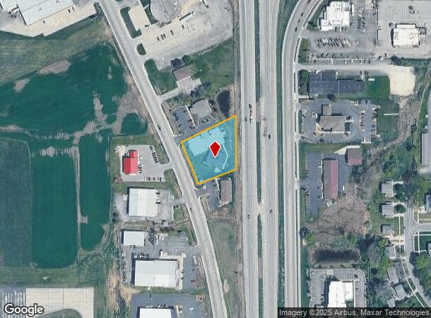
Property Record
145 N Rolling Meadows Dr, Fond Du Lac, WI 54937

NEARBY LISTINGS FOR SALE OR LEASE
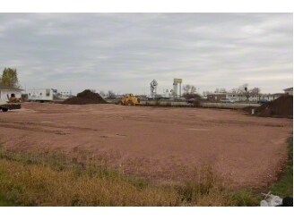
Property Detail
145 N Rolling Meadows Dr
Fond du Lac, WI
Certified Survey Map No 7633
FDL-15-17-08-44-756-02
SEC 08-15-17, PART OF NE1/4 SE1/4 AND SE1/4 SE1/4 DESC AS: LOT 2 OF CSM #7633 V56-40 (F/K/A PART OF LOT 1 OF CSM #7558
Commercialnec
Fond Du Lac
X
Wisconsin
55039C0288F
1-2
2024
0.89 AC
2024
Fond du Lac
040700
Milwaukee/Madison
DEMOGRAPHICS near 145 N Rolling Meadows Dr
1 Mile
3 Mile
5 Mile
2024 Total Population
7,216
43,931
60,017
2029 Population
7,398
44,587
60,599
Pop Growth 2024-2029
+ 2.52%
+ 1.49%
+ 0.97%
Average Age
40
40
41
2024 Total Households
3,562
19,148
25,624
HH Growth 2024-2029
+ 2.55%
+ 1.45%
+ 0.96%
Median Household Inc
$54,769
$57,858
$62,523
Avg Household Size
2.00
2.20
2.20
2024 Avg HH Vehicles
1.00
2.00
2.00
Median Home Value
$152,941
$143,621
$165,729
Median Year Built
1983
1966
1972
Nearby Places
Map Layers
Map Styles
 Street
 Aerial
- Restaurants
- Banks
- Shops
- Fitness
- Groceries
PUBLIC TRANSPORTATION
AIRPORT
Appleton International
DRIVE
WALK
Distance
Appleton International
52 min
43.0 mi
SALE & LEASE HISTORY
LISTING DATE
SALE/LEASE

Sep 24, 2016
For Sale
Nearby Properties
Address
Land Use
TOTAL SIZE
Lot Size
Zoning
Address
Land Use
TOTAL SIZE
Lot Size
Zoning
33.87 AC
Address
Land Use
TOTAL SIZE
Lot Size
Zoning
12.78 AC
Address
Land Use
TOTAL SIZE
Lot Size
Zoning
80.82 AC
Address
Land Use
TOTAL SIZE
Lot Size
Zoning
19,542 SF
12.89 AC
O
Address
Land Use
TOTAL SIZE
Lot Size
Zoning
28.53 AC
Address
Land Use
TOTAL SIZE
Lot Size
Zoning
Address
Land Use
TOTAL SIZE
Lot Size
Zoning
17,798 SF
17.69 AC
M-2
Address
Land Use
TOTAL SIZE
Lot Size
Zoning
2,986 SF
0.60 AC
B-3
Address
Land Use
TOTAL SIZE
Lot Size
Zoning
141,900 SF
16.24 AC
B-5
Address
Land Use
TOTAL SIZE
Lot Size
Zoning
21,135 SF
12.01 AC
B-5
Address
Land Use
TOTAL SIZE
Lot Size
Zoning
2,520 SF
16.04 AC
R-4
Address
Land Use
TOTAL SIZE
Lot Size
Zoning
3,952 SF
15.05 AC
R-5
Address
Land Use
TOTAL SIZE
Lot Size
Zoning
13.38 AC
Address
Land Use
TOTAL SIZE
Lot Size
Zoning
121,500 SF
19.42 AC
M-2
Address
Land Use
TOTAL SIZE
Lot Size
Zoning
28.09 AC
M-1
Address
Land Use
TOTAL SIZE
Lot Size
Zoning
64,570 SF
9.58 AC
B-4
Address
Land Use
TOTAL SIZE
Lot Size
Zoning
Address
Land Use
TOTAL SIZE
Lot Size
Zoning
112,900 SF
10 AC
B-5
Address
Land Use
TOTAL SIZE
Lot Size
Zoning
Address
Land Use
TOTAL SIZE
Lot Size
Zoning
17,202 SF
8.86 AC
M-2
Address
Land Use
TOTAL SIZE
Lot Size
Zoning
16,290 SF
8.45 AC
Address
Land Use
TOTAL SIZE
Lot Size
Zoning
75,000 SF
16.12 AC
M-2
Address
Land Use
TOTAL SIZE
Lot Size
Zoning
1,448 SF
10.26 AC
R-5
Address
Land Use
TOTAL SIZE
Lot Size
Zoning
Address
Land Use
TOTAL SIZE
Lot Size
Zoning
16,260 SF
6.58 AC
Address
Land Use
TOTAL SIZE
Lot Size
Zoning
24,482 SF
7.04 AC
Address
Land Use
TOTAL SIZE
Lot Size
Zoning
42,588 SF
3.01 AC
B-5
Address
Land Use
TOTAL SIZE
Lot Size
Zoning
20.93 AC
M-2
The World's #1 Commercial Real Estate Marketplace
Connect with us
© 2025 CoStar Group
The information above has been obtained from sources believed reliable. While we do not doubt its accuracy we have not verified it and make no guarantee, warranty or representation about it. It is your responsibility to independently confirm its accuracy and completeness. Any projections, opinions, assumptions, or estimates used are for example only and do not represent the current or future performance of the property. The value of this transaction to you depends on tax and other factors which should be evaluated by your tax, financial, and legal advisors. You and your advisors should conduct a careful, independent investigation of the property to determine to your satisfaction the suitability of the property for your needs.