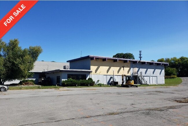
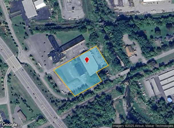
Property Record
145 New Hartford St, New Hartford, NY 13413
NEARBY LISTINGS FOR SALE OR LEASE
Property Detail
145 New Hartford St
329-006-0003-020-000-0000
Oneida
Gymhealthspa
New York
X
20.000
36065C0733F
3.30 AC
2024
Outlying Oneida County
2024
Utica/Rome
025200
Utica-Rome, NY
41,172 SF
DEMOGRAPHICS near 145 New Hartford St
1 Mile
3 Mile
5 Mile
2024 Total Population
5,776
61,399
102,077
2029 Population
5,671
60,512
100,037
Pop Growth 2024-2029
(1.82%)
(1.44%)
(2.00%)
Average Age
43
41
40
2024 Total Households
2,757
25,698
42,117
HH Growth 2024-2029
(1.99%)
(1.50%)
(1.99%)
Median Household Inc
$58,832
$55,566
$53,707
Avg Household Size
2.00
2.30
2.30
2024 Avg HH Vehicles
2.00
1.00
1.00
Median Home Value
$151,273
$160,334
$158,156
Median Year Built
1954
1951
1951
Nearby Places
- Restaurants
- Banks
- Shops
- Fitness
- Groceries
PUBLIC TRANSPORTATION
COMMUTER RAIL
DRIVE
WALK
Distance
9 min
4.3 mi
DRIVE
WALK
Distance
10 min
4.4 mi
SALE & LEASE HISTORY
LISTING DATE
SALE/LEASE

Sep 24, 2016
For Sale
Apr 27, 2022
For Sale
Nearby Properties
Address
Land Use
TOTAL SIZE
Lot Size
Zoning
Address
Land Use
TOTAL SIZE
Lot Size
Zoning
271,000 SF
16.50 AC
Address
Land Use
TOTAL SIZE
Lot Size
Zoning
446,163 SF
24.07 AC
05 - COMME
Address
Land Use
TOTAL SIZE
Lot Size
Zoning
74,414 SF
45.44 AC
01
Address
Land Use
TOTAL SIZE
Lot Size
Zoning
279,786 SF
121 AC
Address
Land Use
TOTAL SIZE
Lot Size
Zoning
236,597 SF
2.10 AC
Address
Land Use
TOTAL SIZE
Lot Size
Zoning
250,115 SF
21.80 AC
05 - COMME
Address
Land Use
TOTAL SIZE
Lot Size
Zoning
109,000 SF
13.56 AC
01 - NOT Z
Address
Land Use
TOTAL SIZE
Lot Size
Zoning
3,276 SF
6.38 AC
05 - COMME
Address
Land Use
TOTAL SIZE
Lot Size
Zoning
124,950 SF
0.01 AC
05 - COMME
Address
Land Use
TOTAL SIZE
Lot Size
Zoning
2,565 SF
216.10 AC
05 - COMME
Address
Land Use
TOTAL SIZE
Lot Size
Zoning
131,760 SF
120.07 AC
05 - COMME
Address
Land Use
TOTAL SIZE
Lot Size
Zoning
235,132 SF
21.09 AC
01 - NOT Z
Address
Land Use
TOTAL SIZE
Lot Size
Zoning
50,000 SF
4.20 AC
05 - COMME
Address
Land Use
TOTAL SIZE
Lot Size
Zoning
208,247 SF
20.43 AC
Address
Land Use
TOTAL SIZE
Lot Size
Zoning
131,534 SF
16 AC
05 - COMME
Address
Land Use
TOTAL SIZE
Lot Size
Zoning
1,085,454 SF
101.28 AC
05 - COMME
Address
Land Use
TOTAL SIZE
Lot Size
Zoning
25,860 SF
18.45 AC
05 - COMME
Address
Land Use
TOTAL SIZE
Lot Size
Zoning
55,172 SF
81.24 AC
Address
Land Use
TOTAL SIZE
Lot Size
Zoning
3,276 SF
5.33 AC
05 - COMME
Address
Land Use
TOTAL SIZE
Lot Size
Zoning
129,456 SF
15.02 AC
01 - NOT Z
Address
Land Use
TOTAL SIZE
Lot Size
Zoning
55,916 SF
4.50 AC
Address
Land Use
TOTAL SIZE
Lot Size
Zoning
292,687 SF
41.33 AC
05 - COMME
Address
Land Use
TOTAL SIZE
Lot Size
Zoning
32,000 SF
3.07 AC
01 - NOT Z
Address
Land Use
TOTAL SIZE
Lot Size
Zoning
98,900 SF
28.20 AC
05 - COMME
Address
Land Use
TOTAL SIZE
Lot Size
Zoning
137,933 SF
15.13 AC
Address
Land Use
TOTAL SIZE
Lot Size
Zoning
5,580 SF
0.74 AC
Address
Land Use
TOTAL SIZE
Lot Size
Zoning
149,008 SF
14.10 AC
Address
Land Use
TOTAL SIZE
Lot Size
Zoning
64,016 SF
57.30 AC
05 - COMME
Address
Land Use
TOTAL SIZE
Lot Size
Zoning
194,300 SF
30.09 AC
05 - COMME
Address
Land Use
TOTAL SIZE
Lot Size
Zoning
130,543 SF
12.07 AC
05 - COMME
The World's #1 Commercial Real Estate Marketplace
Connect with us
© 2025 CoStar Group
The information above has been obtained from sources believed reliable. While we do not doubt its accuracy we have not verified it and make no guarantee, warranty or representation about it. It is your responsibility to independently confirm its accuracy and completeness. Any projections, opinions, assumptions, or estimates used are for example only and do not represent the current or future performance of the property. The value of this transaction to you depends on tax and other factors which should be evaluated by your tax, financial, and legal advisors. You and your advisors should conduct a careful, independent investigation of the property to determine to your satisfaction the suitability of the property for your needs.