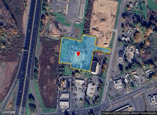
Property Record
145 Prospect Hill Rd, East Windsor, CT 06088

NEARBY LISTINGS FOR SALE OR LEASE
Property Detail
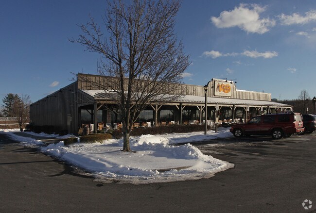
145 Prospect Hill Rd
EWIN-000112-000004-000026C
Hartford
Commercialbuilding
Connecticut
X
26c
09003C0236F
3.13 AC
2025
East Windsor
2025
Hartford
484100
Hartford-West Hartford-East Hartford, CT
9,862 SF
DEMOGRAPHICS near 145 Prospect Hill Rd
1 Mile
3 Mile
5 Mile
2024 Total Population
1,612
26,249
64,549
2029 Population
1,620
26,153
64,257
Pop Growth 2024-2029
+ 0.50%
(0.37%)
(0.45%)
Average Age
45
44
43
2024 Total Households
729
11,411
26,439
HH Growth 2024-2029
+ 0.27%
(0.41%)
(0.60%)
Median Household Inc
$85,657
$85,079
$86,792
Avg Household Size
2.00
2.20
2.30
2024 Avg HH Vehicles
2.00
2.00
2.00
Median Home Value
$198,097
$232,553
$252,992
Median Year Built
1962
1967
1968
Nearby Places
Map Layers
Map Styles
 Street
 Aerial
- Restaurants
- Banks
- Shops
- Fitness
- Groceries
PUBLIC TRANSPORTATION
COMMUTER RAIL
Windsor Locks (Hartford Line - CT Rail (CTRail))
DRIVE
WALK
Distance
Windsor Locks (Hartford Line - CT Rail (CTRail))
5 min
2.7 mi
Windsor (Amtrak Hartford Line - Amtrak, Hartford Line - Amtrak, Northeast Regional - Amtrak, Valley Flyer - Amtrak)
DRIVE
WALK
Distance
Windsor (Amtrak Hartford Line - Amtrak, Hartford Line - Amtrak, Northeast Regional - Amtrak, Valley Flyer - Amtrak)
13 min
8.3 mi
AIRPORT
Bradley International
DRIVE
WALK
Distance
Bradley International
21 min
7.8 mi
Freight Ports
Port of New Haven
DRIVE
WALK
Distance
Port of New Haven
67 min
51.5 mi
Nearby Properties
Address
Land Use
TOTAL SIZE
Lot Size
Zoning
Address
Land Use
TOTAL SIZE
Lot Size
Zoning
Address
Land Use
TOTAL SIZE
Lot Size
Zoning
201,978 SF
53.95 AC
R88
Address
Land Use
TOTAL SIZE
Lot Size
Zoning
143,800 SF
Address
Land Use
TOTAL SIZE
Lot Size
Zoning
4,418 SF
106 AC
MFDD
Address
Land Use
TOTAL SIZE
Lot Size
Zoning
126,079 SF
38.72 AC
TZ5
Address
Land Use
TOTAL SIZE
Lot Size
Zoning
176,152 SF
27 AC
R44
Address
Land Use
TOTAL SIZE
Lot Size
Zoning
177,366 SF
61.60 AC
RESA
Address
Land Use
TOTAL SIZE
Lot Size
Zoning
190,997 SF
18.47 AC
M-1
Address
Land Use
TOTAL SIZE
Lot Size
Zoning
277,552 SF
40.24 AC
M-1
Address
Land Use
TOTAL SIZE
Lot Size
Zoning
12.14 AC
I
Address
Land Use
TOTAL SIZE
Lot Size
Zoning
117,699 SF
6.83 AC
MFDD
Address
Land Use
TOTAL SIZE
Lot Size
Zoning
2,867 SF
17.27 AC
R-2
Address
Land Use
TOTAL SIZE
Lot Size
Zoning
124,964 SF
RESA
Address
Land Use
TOTAL SIZE
Lot Size
Zoning
11,952 SF
25 AC
MFDD
Address
Land Use
TOTAL SIZE
Lot Size
Zoning
Address
Land Use
TOTAL SIZE
Lot Size
Zoning
21.50 AC
R25
Address
Land Use
TOTAL SIZE
Lot Size
Zoning
44,054 SF
16.87 AC
A-1
Address
Land Use
TOTAL SIZE
Lot Size
Zoning
34,045 SF
181.32 AC
B-2
Address
Land Use
TOTAL SIZE
Lot Size
Zoning
14,295 SF
24.45 AC
R-1
Address
Land Use
TOTAL SIZE
Lot Size
Zoning
14,864 SF
0.25 AC
IND1
Address
Land Use
TOTAL SIZE
Lot Size
Zoning
15.58 AC
RESA
Address
Land Use
TOTAL SIZE
Lot Size
Zoning
150,000 SF
22.20 AC
M-1
Address
Land Use
TOTAL SIZE
Lot Size
Zoning
243,624 SF
12.16 AC
I
Address
Land Use
TOTAL SIZE
Lot Size
Zoning
20.54 AC
R33
Address
Land Use
TOTAL SIZE
Lot Size
Zoning
52.53 AC
Address
Land Use
TOTAL SIZE
Lot Size
Zoning
12 AC
HR33
Address
Land Use
TOTAL SIZE
Lot Size
Zoning
Address
Land Use
TOTAL SIZE
Lot Size
Zoning
18.04 AC
R33
Address
Land Use
TOTAL SIZE
Lot Size
Zoning
112,820 SF
8.98 AC
BUS1
Address
Land Use
TOTAL SIZE
Lot Size
Zoning
35.52 AC
R25
The World's #1 Commercial Real Estate Marketplace
Connect with us
© 2025 CoStar Group
The information above has been obtained from sources believed reliable. While we do not doubt its accuracy we have not verified it and make no guarantee, warranty or representation about it. It is your responsibility to independently confirm its accuracy and completeness. Any projections, opinions, assumptions, or estimates used are for example only and do not represent the current or future performance of the property. The value of this transaction to you depends on tax and other factors which should be evaluated by your tax, financial, and legal advisors. You and your advisors should conduct a careful, independent investigation of the property to determine to your satisfaction the suitability of the property for your needs.