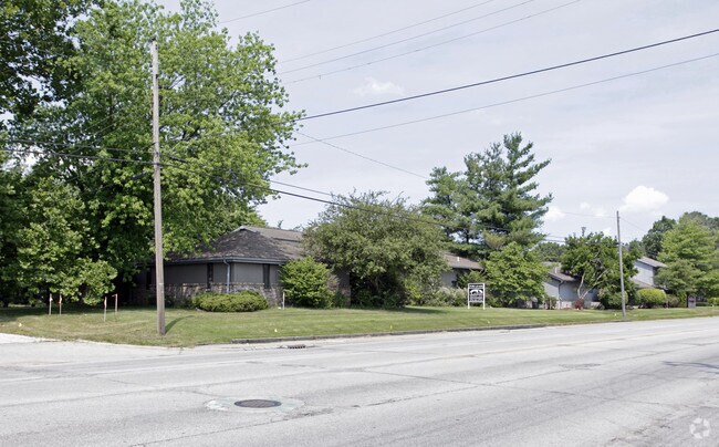
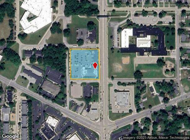
Property Record
145 S Nappanee St, Elkhart, IN 46514
NEARBY LISTINGS FOR SALE OR LEASE
Property Detail
145 S Nappanee St
Elkhart-Goshen, IN
H N Winegar Add
20-05-01-478-006.000-006
H N WINEGAR ADD LOTS 16 THRU 29 EX E PT FOR ROW
Medicalbuilding
Elkhart
X
Indiana
18039C0117D
16-29
2024
1.90 AC
2025
Outlying Elkhart County
001501
South Bend/Mishawaka
24,086 SF
DEMOGRAPHICS near 145 S Nappanee St
1 Mile
3 Mile
5 Mile
2024 Total Population
7,018
54,472
103,500
2029 Population
7,032
54,830
103,469
Pop Growth 2024-2029
+ 0.20%
+ 0.66%
(0.03%)
Average Age
37
37
38
2024 Total Households
2,570
20,081
38,703
HH Growth 2024-2029
+ 0.12%
+ 0.74%
(0.01%)
Median Household Inc
$46,559
$47,704
$55,638
Avg Household Size
2.60
2.60
2.60
2024 Avg HH Vehicles
2.00
2.00
2.00
Median Home Value
$117,097
$124,879
$154,942
Median Year Built
1950
1962
1972
Nearby Places
Map Layers
Map Styles
 Street
 Aerial
- Restaurants
- Banks
- Shops
- Fitness
- Groceries
PUBLIC TRANSPORTATION
COMMUTER RAIL
DRIVE
WALK
Distance
4 min
2.0 mi
AIRPORT
South Bend International
DRIVE
WALK
Distance
South Bend International
43 min
19.2 mi
SALE & LEASE HISTORY
LISTING DATE
SALE/LEASE

Nov 08, 2022
For Lease
Nearby Properties
Address
Land Use
TOTAL SIZE
Lot Size
Zoning
Address
Land Use
TOTAL SIZE
Lot Size
Zoning
373,218 SF
14.58 AC
ZO01
Address
Land Use
TOTAL SIZE
Lot Size
Zoning
133,214 SF
0.30 AC
ZO01
Address
Land Use
TOTAL SIZE
Lot Size
Zoning
538,127 SF
39.88 AC
ZO01
Address
Land Use
TOTAL SIZE
Lot Size
Zoning
630,852 SF
37.12 AC
ZO01
Address
Land Use
TOTAL SIZE
Lot Size
Zoning
315,130 SF
6.54 AC
ZO01
Address
Land Use
TOTAL SIZE
Lot Size
Zoning
334,473 SF
24.88 AC
ZO01
Address
Land Use
TOTAL SIZE
Lot Size
Zoning
158,688 SF
20.79 AC
ZO01
Address
Land Use
TOTAL SIZE
Lot Size
Zoning
333,124 SF
16.47 AC
ZO01
Address
Land Use
TOTAL SIZE
Lot Size
Zoning
300,000 SF
68.80 AC
ZO01
Address
Land Use
TOTAL SIZE
Lot Size
Zoning
377,169 SF
23.85 AC
ZO01
Address
Land Use
TOTAL SIZE
Lot Size
Zoning
106,029 SF
35.15 AC
ZO01
Address
Land Use
TOTAL SIZE
Lot Size
Zoning
36,851 SF
22.72 AC
Address
Land Use
TOTAL SIZE
Lot Size
Zoning
129,147 SF
3.23 AC
Address
Land Use
TOTAL SIZE
Lot Size
Zoning
189,262 SF
23.71 AC
ZO01
Address
Land Use
TOTAL SIZE
Lot Size
Zoning
70,800 SF
0.92 AC
ZO01
Address
Land Use
TOTAL SIZE
Lot Size
Zoning
128,225 SF
12.56 AC
ZO01
Address
Land Use
TOTAL SIZE
Lot Size
Zoning
277,504 SF
18.61 AC
ZO01
Address
Land Use
TOTAL SIZE
Lot Size
Zoning
203,685 SF
17.74 AC
ZO01
Address
Land Use
TOTAL SIZE
Lot Size
Zoning
301,018 SF
19.68 AC
ZO01
Address
Land Use
TOTAL SIZE
Lot Size
Zoning
204,010 SF
32.52 AC
ZO01
Address
Land Use
TOTAL SIZE
Lot Size
Zoning
316,658 SF
27.46 AC
Address
Land Use
TOTAL SIZE
Lot Size
Zoning
56,310 SF
2.85 AC
ZO01
Address
Land Use
TOTAL SIZE
Lot Size
Zoning
257,024 SF
9.99 AC
ZO01
Address
Land Use
TOTAL SIZE
Lot Size
Zoning
89,295 SF
4.03 AC
ZO01
Address
Land Use
TOTAL SIZE
Lot Size
Zoning
223,713 SF
14.05 AC
ZO01
Address
Land Use
TOTAL SIZE
Lot Size
Zoning
81,452 SF
33.51 AC
ZO01
Address
Land Use
TOTAL SIZE
Lot Size
Zoning
65,387 SF
7.72 AC
ZO01
Address
Land Use
TOTAL SIZE
Lot Size
Zoning
240,587 SF
12 AC
ZO01
Address
Land Use
TOTAL SIZE
Lot Size
Zoning
144,000 SF
18.31 AC
ZO01
Address
Land Use
TOTAL SIZE
Lot Size
Zoning
38,520 SF
3.31 AC
ZO01
The World's #1 Commercial Real Estate Marketplace
Connect with us
© 2026 CoStar Group
The information above has been obtained from sources believed reliable. While we do not doubt its accuracy we have not verified it and make no guarantee, warranty or representation about it. It is your responsibility to independently confirm its accuracy and completeness. Any projections, opinions, assumptions, or estimates used are for example only and do not represent the current or future performance of the property. The value of this transaction to you depends on tax and other factors which should be evaluated by your tax, financial, and legal advisors. You and your advisors should conduct a careful, independent investigation of the property to determine to your satisfaction the suitability of the property for your needs.