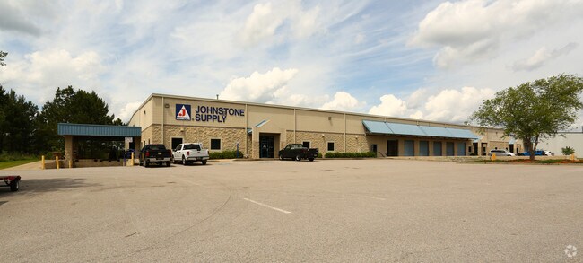
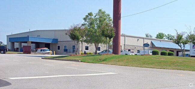
Property Record
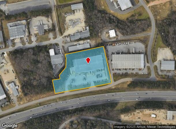
145 Winhill Rd, Columbia, SC 29203
NEARBY LISTINGS FOR SALE OR LEASE
Property Detail
145 Winhill Rd
09413-01-08
PARCEL A 631.2X139.6X56.8X10X38.5X110.7 X101.5X45.1X445.4X425.3 #PR X-914 RB1156-3693
Commercialnec
Richland
X
South Carolina
45079C0233L
4.98 AC
2025
North Columbia
2024
Columbia
010701
Columbia, SC
50,850 SF
DEMOGRAPHICS near 145 Winhill Rd
1 mile
3 mile
5 mile
2024 Total Population
2,028
36,041
117,388
2029 Population
2,081
36,855
119,808
Pop Growth 2024-2029
+ 2.61%
+ 2.26%
+ 2.06%
Average Age
39
39
38
2024 Total Households
897
15,506
50,630
HH Growth 2024-2029
+ 2.68%
+ 2.31%
+ 2.20%
Median Household Inc
$30,308
$33,861
$40,530
Avg Household Size
2.20
2.30
2.10
2024 Avg HH Vehicles
1.00
1.00
1.00
Median Home Value
$82,856
$107,109
$159,172
Median Year Built
1966
1967
1971
Nearby Places
Map Layers
Map Styles
 Street
 Aerial
Transit
 Traffic
 Biking
Places
Listings with unknown addresses are not visible on the map
- Restaurants
- Banks
- Shops
- Fitness
- Groceries
PUBLIC TRANSPORTATION
COMMUTER RAIL
Drive
Walk
Distance
16 min
6.1 mi
AIRPORT
Columbia Metro
Drive
Walk
Distance
Columbia Metro
29 min
15.4 mi
Nearby Properties
Address
Land Use
TOTAL SIZE
Lot Size
Zoning
Address
Land Use
TOTAL SIZE
Lot Size
Zoning
20,434 SF
17.20 AC
C-1
Address
Land Use
TOTAL SIZE
Lot Size
Zoning
278,912 SF
23.24 AC
RM-HD
Address
Land Use
TOTAL SIZE
Lot Size
Zoning
2,456 SF
5 AC
C-1
Address
Land Use
TOTAL SIZE
Lot Size
Zoning
96,189 SF
2.22 AC
C-1
Address
Land Use
TOTAL SIZE
Lot Size
Zoning
127,063 SF
14.70 AC
RM-HD
Address
Land Use
TOTAL SIZE
Lot Size
Zoning
34,393 SF
2.96 AC
M-1
Address
Land Use
TOTAL SIZE
Lot Size
Zoning
67,200 SF
1.72 AC
C-1
Address
Land Use
TOTAL SIZE
Lot Size
Zoning
90,430 SF
0.42 AC
C-1
Address
Land Use
TOTAL SIZE
Lot Size
Zoning
23,916 SF
4.43 AC
RG-2
Address
Land Use
TOTAL SIZE
Lot Size
Zoning
124,272 SF
7.06 AC
RM-HD
Address
Land Use
TOTAL SIZE
Lot Size
Zoning
100 SF
44.73 AC
C-1
Address
Land Use
TOTAL SIZE
Lot Size
Zoning
63,842 SF
3.52 AC
C-3
Address
Land Use
TOTAL SIZE
Lot Size
Zoning
4,986 SF
5.74 AC
PUD-C
Address
Land Use
TOTAL SIZE
Lot Size
Zoning
98,436 SF
14 AC
INS-GEN
Address
Land Use
TOTAL SIZE
Lot Size
Zoning
103,405 SF
0.38 AC
C-3
Address
Land Use
TOTAL SIZE
Lot Size
Zoning
82,692 SF
5.87 AC
C-3
Address
Land Use
TOTAL SIZE
Lot Size
Zoning
134,400 SF
5.85 AC
RG-2
Address
Land Use
TOTAL SIZE
Lot Size
Zoning
199,962 SF
40.13 AC
RG-1
Address
Land Use
TOTAL SIZE
Lot Size
Zoning
96,248 SF
5.97 AC
RM-2
Address
Land Use
TOTAL SIZE
Lot Size
Zoning
8,032 SF
3.20 AC
C-1
Address
Land Use
TOTAL SIZE
Lot Size
Zoning
32,030 SF
1.06 AC
M-1
Address
Land Use
TOTAL SIZE
Lot Size
Zoning
1,562 SF
17.22 AC
PUD-1R
Address
Land Use
TOTAL SIZE
Lot Size
Zoning
194,212 SF
15.10 AC
RG-2
Address
Land Use
TOTAL SIZE
Lot Size
Zoning
107,302 SF
16.77 AC
EC
Address
Land Use
TOTAL SIZE
Lot Size
Zoning
67,800 SF
1.54 AC
C-1
Address
Land Use
TOTAL SIZE
Lot Size
Zoning
58,094 SF
4.43 AC
M-1
Address
Land Use
TOTAL SIZE
Lot Size
Zoning
183,690 SF
16.17 AC
RG-2
Address
Land Use
TOTAL SIZE
Lot Size
Zoning
75,981 SF
1.33 AC
C-1
Address
Land Use
TOTAL SIZE
Lot Size
Zoning
42,735 SF
2.12 AC
C-1
Address
Land Use
TOTAL SIZE
Lot Size
Zoning
83,296 SF
5.33 AC
RS-3
The World's #1 Commercial Real Estate Marketplace
Connect with us
© 2026 CoStar Group
The information above has been obtained from sources believed reliable. While we do not doubt its accuracy we have not verified it and make no guarantee, warranty or representation about it. It is your responsibility to independently confirm its accuracy and completeness. Any projections, opinions, assumptions, or estimates used are for example only and do not represent the current or future performance of the property. The value of this transaction to you depends on tax and other factors which should be evaluated by your tax, financial, and legal advisors. You and your advisors should conduct a careful, independent investigation of the property to determine to your satisfaction the suitability of the property for your needs.