Property Record
Nardo St, Ventura, CA 93004
Current Lease Availabilities
NEARBY LISTINGS FOR SALE OR LEASE
Property Detail
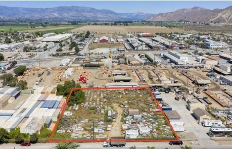
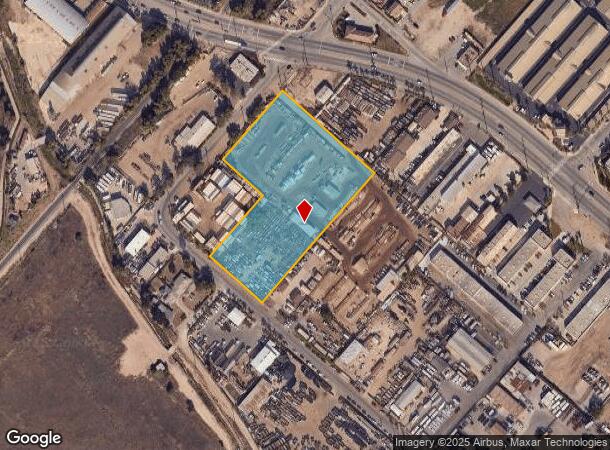
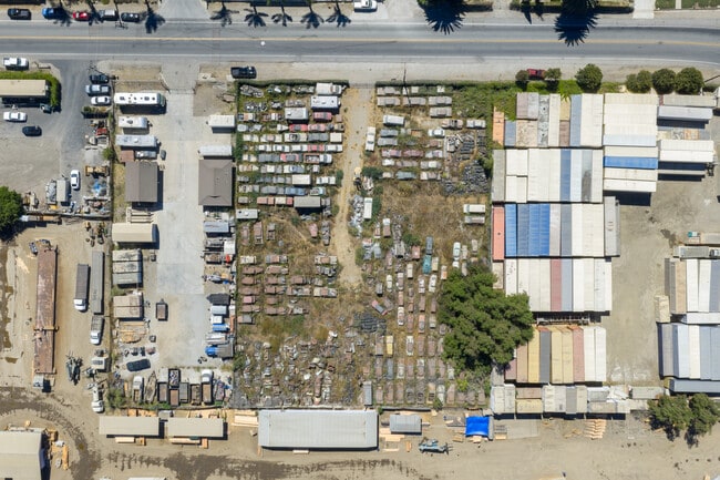
Nardo St
Oxnard-Thousand Oaks-Ventura, CA
LOT: 1
128-0-022-075
Ventura
Industrialacreage
California
X
1
06111C0770E
4.05 AC
2024
Ventura
2025
Los Angeles
001301
DEMOGRAPHICS near Nardo St
1 Mile
3 Mile
5 Mile
2024 Total Population
9,978
44,551
132,699
2029 Population
9,930
44,240
132,121
Pop Growth 2024-2029
(0.48%)
(0.70%)
(0.44%)
Average Age
40
41
40
2024 Total Households
3,410
15,316
43,948
HH Growth 2024-2029
(0.65%)
(0.79%)
(0.51%)
Median Household Inc
$107,385
$117,183
$108,747
Avg Household Size
2.80
2.80
2.90
2024 Avg HH Vehicles
2.00
2.00
2.00
Median Home Value
$686,922
$739,519
$749,942
Median Year Built
1983
1980
1980
Nearby Places
- Restaurants
- Banks
- Shops
- Fitness
- Groceries
PUBLIC TRANSPORTATION
COMMUTER RAIL
East Ventura Metrolink Station (Metrolink Ventura County Line - Metrolink Trains)
DRIVE
WALK
Distance
East Ventura Metrolink Station (Metrolink Ventura County Line - Metrolink Trains)
10 min
5.0 mi
Oxnard (Ventura County Line - Southern California Regional Rail Authority (Metrolink))
DRIVE
WALK
Distance
Oxnard (Ventura County Line - Southern California Regional Rail Authority (Metrolink))
13 min
7.2 mi
Freight Ports
The Port of Hueneme
DRIVE
WALK
Distance
The Port of Hueneme
21 min
11.7 mi
Nearby Properties
Address
Land Use
TOTAL SIZE
Lot Size
Zoning
Address
Land Use
TOTAL SIZE
Lot Size
Zoning
205,396 SF
12.48 AC
Address
Land Use
TOTAL SIZE
Lot Size
Zoning
24,154 SF
12.67 AC
R3-1
Address
Land Use
TOTAL SIZE
Lot Size
Zoning
4.76 AC
Address
Land Use
TOTAL SIZE
Lot Size
Zoning
151,422 SF
6.67 AC
Address
Land Use
TOTAL SIZE
Lot Size
Zoning
4.41 AC
Address
Land Use
TOTAL SIZE
Lot Size
Zoning
102,046 SF
3.72 AC
Address
Land Use
TOTAL SIZE
Lot Size
Zoning
87,804 SF
6.68 AC
RPD-
Address
Land Use
TOTAL SIZE
Lot Size
Zoning
3,725 SF
429.19 AC
AE
Address
Land Use
TOTAL SIZE
Lot Size
Zoning
1.09 AC
Address
Land Use
TOTAL SIZE
Lot Size
Zoning
45,925 SF
1.68 AC
Address
Land Use
TOTAL SIZE
Lot Size
Zoning
64,976 SF
3 AC
R3-5D
Address
Land Use
TOTAL SIZE
Lot Size
Zoning
46,507 SF
1.02 AC
C1A
Address
Land Use
TOTAL SIZE
Lot Size
Zoning
53,658 SF
3.18 AC
RPD-1
Address
Land Use
TOTAL SIZE
Lot Size
Zoning
10,995 SF
17.26 AC
M2
Address
Land Use
TOTAL SIZE
Lot Size
Zoning
1.59 AC
POD
Address
Land Use
TOTAL SIZE
Lot Size
Zoning
34,819 SF
1.28 AC
R3-2
Address
Land Use
TOTAL SIZE
Lot Size
Zoning
3.89 AC
7
Address
Land Use
TOTAL SIZE
Lot Size
Zoning
2.88 AC
POD
Address
Land Use
TOTAL SIZE
Lot Size
Zoning
1.52 AC
Address
Land Use
TOTAL SIZE
Lot Size
Zoning
153.13 AC
AE/MRP
Address
Land Use
TOTAL SIZE
Lot Size
Zoning
41.50 AC
AE/MRP
Address
Land Use
TOTAL SIZE
Lot Size
Zoning
262,132 SF
6.28 AC
M1
Address
Land Use
TOTAL SIZE
Lot Size
Zoning
103,938 SF
4.78 AC
R3-3
Address
Land Use
TOTAL SIZE
Lot Size
Zoning
30,052 SF
6.55 AC
M2
Address
Land Use
TOTAL SIZE
Lot Size
Zoning
84,956 SF
3.24 AC
R32
Address
Land Use
TOTAL SIZE
Lot Size
Zoning
94.13 AC
AE
Address
Land Use
TOTAL SIZE
Lot Size
Zoning
4,160 SF
2.19 AC
The World's #1 Commercial Real Estate Marketplace
Connect with us
© 2025 CoStar Group
The information above has been obtained from sources believed reliable. While we do not doubt its accuracy we have not verified it and make no guarantee, warranty or representation about it. It is your responsibility to independently confirm its accuracy and completeness. Any projections, opinions, assumptions, or estimates used are for example only and do not represent the current or future performance of the property. The value of this transaction to you depends on tax and other factors which should be evaluated by your tax, financial, and legal advisors. You and your advisors should conduct a careful, independent investigation of the property to determine to your satisfaction the suitability of the property for your needs.