Property Record
1450 Poplar St, Wrightstown, WI 54180
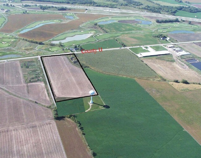
Property Detail
1450 Poplar St
Green Bay
25,881 SQ FT OUTLOT 1 OF 51 CSM 165 BNG PRT OF SW1/4 NW1/4 SEC 34 T22N R19E
Green Bay, WI
BROWN
VW-W175
Wisconsin
Industrialgeneral
1
2025
10.07 AC
2025
Ashwaubenon
021400
NEARBY LISTINGS FOR SALE OR LEASE
-
-
View all Wrightstown listings for sale on LoopNet.com
DEMOGRAPHICS near 1450 Poplar St
1 mile
3 mile
5 mile
2025 Total Population
989
5,128
12,451
2030 Population
1,009
5,257
12,782
Pop Growth 2025-2030
+ 2.02%
+ 2.52%
+ 2.66%
Average Age
39
38
39
2025 Total Households
389
1,906
4,649
HH Growth 2025-2030
+ 2.06%
+ 2.47%
+ 2.58%
Median Household Inc
$99,166
$102,984
$105,266
Avg Household Size
2.50
2.70
2.70
2025 Avg HH Vehicles
2.00
2.00
2.00
Median Home Value
$366,922
$311,765
$334,610
Median Year Built
1996
1995
1994
Nearby Places
Map Layers
Map Styles
 Street
 Aerial
Layers
 Traffic
 Biking
Places
Listings with unknown addresses are not visible on the map
- Restaurants
- Banks
- Shops
- Fitness
- Groceries
PUBLIC TRANSPORTATION
AIRPORT
Green Bay/Austin Straubel International
Drive
Walk
Distance
Green Bay/Austin Straubel International
21 min
13.9 mi
Appleton International
Drive
Walk
Distance
Appleton International
30 min
23.2 mi
Freight Ports
Port Milwaukee
Drive
Walk
Distance
Port Milwaukee
144 min
124.9 mi
SALE & LEASE HISTORY
LISTING DATE
SALE/LEASE

Apr 13, 2017
For Sale
Nearby Properties
Address
Land Use
TOTAL SIZE
Lot Size
Zoning
Address
Land Use
TOTAL SIZE
Lot Size
Zoning
Address
Land Use
TOTAL SIZE
Lot Size
Zoning
12.95 AC
Address
Land Use
TOTAL SIZE
Lot Size
Zoning
19.22 AC
Address
Land Use
TOTAL SIZE
Lot Size
Zoning
24.05 AC
Address
Land Use
TOTAL SIZE
Lot Size
Zoning
20.27 AC
Address
Land Use
TOTAL SIZE
Lot Size
Zoning
32.20 AC
Address
Land Use
TOTAL SIZE
Lot Size
Zoning
6.94 AC
Address
Land Use
TOTAL SIZE
Lot Size
Zoning
19.58 AC
Address
Land Use
TOTAL SIZE
Lot Size
Zoning
10.07 AC
Address
Land Use
TOTAL SIZE
Lot Size
Zoning
11.85 AC
Address
Land Use
TOTAL SIZE
Lot Size
Zoning
2.82 AC
Address
Land Use
TOTAL SIZE
Lot Size
Zoning
22.42 AC
Address
Land Use
TOTAL SIZE
Lot Size
Zoning
7.45 AC
Address
Land Use
TOTAL SIZE
Lot Size
Zoning
11.25 AC
Address
Land Use
TOTAL SIZE
Lot Size
Zoning
Address
Land Use
TOTAL SIZE
Lot Size
Zoning
Address
Land Use
TOTAL SIZE
Lot Size
Zoning
38.46 AC
Address
Land Use
TOTAL SIZE
Lot Size
Zoning
7.17 AC
Address
Land Use
TOTAL SIZE
Lot Size
Zoning
9.83 AC
Address
Land Use
TOTAL SIZE
Lot Size
Zoning
11.16 AC
Address
Land Use
TOTAL SIZE
Lot Size
Zoning
13.20 AC
Address
Land Use
TOTAL SIZE
Lot Size
Zoning
Address
Land Use
TOTAL SIZE
Lot Size
Zoning
Address
Land Use
TOTAL SIZE
Lot Size
Zoning
Address
Land Use
TOTAL SIZE
Lot Size
Zoning
Address
Land Use
TOTAL SIZE
Lot Size
Zoning
Address
Land Use
TOTAL SIZE
Lot Size
Zoning
15.54 AC
Address
Land Use
TOTAL SIZE
Lot Size
Zoning
Address
Land Use
TOTAL SIZE
Lot Size
Zoning
Address
Land Use
TOTAL SIZE
Lot Size
Zoning
2.24 AC
The World's #1 Commercial Real Estate Marketplace
Connect with us
© 2026 CoStar Group
The information above has been obtained from sources believed reliable. While we do not doubt its accuracy we have not verified it and make no guarantee, warranty or representation about it. It is your responsibility to independently confirm its accuracy and completeness. Any projections, opinions, assumptions, or estimates used are for example only and do not represent the current or future performance of the property. The value of this transaction to you depends on tax and other factors which should be evaluated by your tax, financial, and legal advisors. You and your advisors should conduct a careful, independent investigation of the property to determine to your satisfaction the suitability of the property for your needs.