Property Record
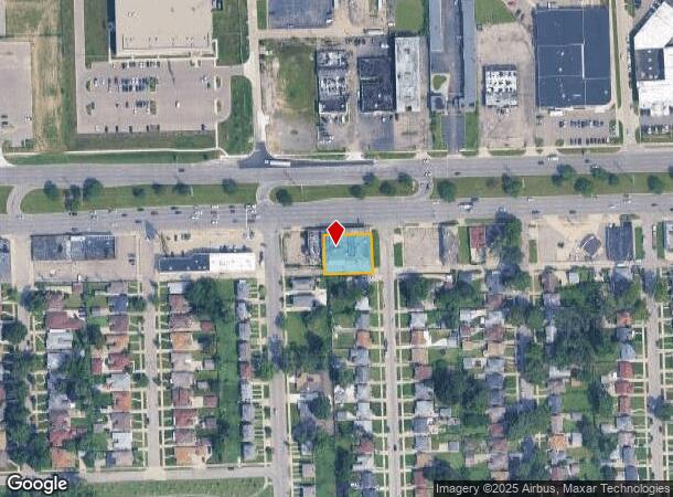
14501 W 8 Mile Rd, Detroit, MI 48235
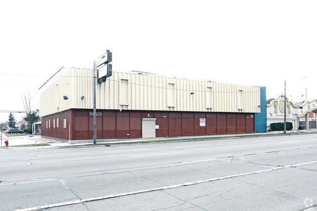
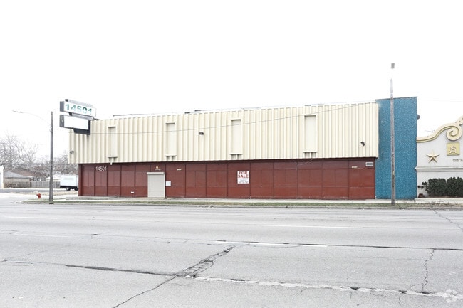
This Property Is For Sale
NEARBY LISTINGS FOR SALE OR LEASE
Property Detail
14501 W 8 Mile Rd
22-018638
More Than One Legal Involved
Wholesaleoutletdiscountstore
S EIGHT MILE W ALL THAT PT OF N E 1/4 OF SEC 6 T 1 S R 11 E DESC AS FOLS--BEG AT A PTE DIST N 88D 24M 05S E 258.30 FT TH S 1D 55M 52S E 153 FT FROM N 1/4 POST OF SEC 6 TH S 88D 24M 05S W 125.32 FT TH N 1D 49M 52S W 100 FT TH N 88D 24M 05S E 125.15 FT
X
Wayne
26163C0100E
Michigan
2024
0.29 AC
2025
Royal Oak
539200
Detroit
9,941 SF
Detroit-Warren-Dearborn, MI
DEMOGRAPHICS near 14501 W 8 Mile Rd
1 Mile
3 Mile
5 Mile
2024 Total Population
14,678
159,717
384,239
2029 Population
14,237
156,210
379,607
Pop Growth 2024-2029
(3.00%)
(2.20%)
(1.21%)
Average Age
42
40
40
2024 Total Households
6,151
65,091
161,959
HH Growth 2024-2029
(3.11%)
(2.18%)
(1.18%)
Median Household Inc
$42,509
$50,192
$53,008
Avg Household Size
2.30
2.40
2.30
2024 Avg HH Vehicles
1.00
1.00
1.00
Median Home Value
$91,058
$136,623
$157,266
Median Year Built
1954
1953
1952
Nearby Places
Map Layers
Map Styles
 Street
 Aerial
- Restaurants
- Banks
- Shops
- Fitness
- Groceries
PUBLIC TRANSPORTATION
AIRPORT
Detroit City
DRIVE
WALK
Distance
Detroit City
22 min
12.0 mi
Detroit Metro Wayne County
DRIVE
WALK
Distance
Detroit Metro Wayne County
35 min
27.0 mi
Freight Ports
Port of Baltimore
DRIVE
WALK
Distance
Port of Baltimore
1 min
408.5 mi
Nearby Properties
Address
Land Use
TOTAL SIZE
Lot Size
Zoning
Address
Land Use
TOTAL SIZE
Lot Size
Zoning
925,367 SF
12.82 AC
R6
Address
Land Use
TOTAL SIZE
Lot Size
Zoning
187,801 SF
5.49 AC
RM-2
Address
Land Use
TOTAL SIZE
Lot Size
Zoning
300,830 SF
54 AC
LI
Address
Land Use
TOTAL SIZE
Lot Size
Zoning
120,093 SF
38.18 AC
TV-R
Address
Land Use
TOTAL SIZE
Lot Size
Zoning
339,780 SF
22.29 AC
RM-1
Address
Land Use
TOTAL SIZE
Lot Size
Zoning
417,880 SF
6.76 AC
RM-2
Address
Land Use
TOTAL SIZE
Lot Size
Zoning
290,448 SF
9.01 AC
O
Address
Land Use
TOTAL SIZE
Lot Size
Zoning
273,000 SF
17.31 AC
LI
Address
Land Use
TOTAL SIZE
Lot Size
Zoning
10.32 AC
LI
Address
Land Use
TOTAL SIZE
Lot Size
Zoning
133,544 SF
19.65 AC
ERO
Address
Land Use
TOTAL SIZE
Lot Size
Zoning
143,700 SF
3.27 AC
PD
Address
Land Use
TOTAL SIZE
Lot Size
Zoning
163,661 SF
8.92 AC
PD
Address
Land Use
TOTAL SIZE
Lot Size
Zoning
290,448 SF
8.92 AC
O
Address
Land Use
TOTAL SIZE
Lot Size
Zoning
216 SF
13.14 AC
RM
Address
Land Use
TOTAL SIZE
Lot Size
Zoning
240,520 SF
8.14 AC
B-3
Address
Land Use
TOTAL SIZE
Lot Size
Zoning
165,829 SF
5.56 AC
R5
Address
Land Use
TOTAL SIZE
Lot Size
Zoning
Address
Land Use
TOTAL SIZE
Lot Size
Zoning
97.05 AC
RS
Address
Land Use
TOTAL SIZE
Lot Size
Zoning
200 SF
12.69 AC
RM
Address
Land Use
TOTAL SIZE
Lot Size
Zoning
66,032 SF
3.61 AC
R-1
Address
Land Use
TOTAL SIZE
Lot Size
Zoning
180 SF
5.09 AC
RMU
Address
Land Use
TOTAL SIZE
Lot Size
Zoning
176 SF
9.85 AC
RM
Address
Land Use
TOTAL SIZE
Lot Size
Zoning
54,672 SF
1.37 AC
R6
Address
Land Use
TOTAL SIZE
Lot Size
Zoning
116,790 SF
5.86 AC
R4
Address
Land Use
TOTAL SIZE
Lot Size
Zoning
107,914 SF
6.41 AC
B-2
Address
Land Use
TOTAL SIZE
Lot Size
Zoning
90,958 SF
11.78 AC
R5
Address
Land Use
TOTAL SIZE
Lot Size
Zoning
Address
Land Use
TOTAL SIZE
Lot Size
Zoning
190 SF
4.68 AC
RT
Address
Land Use
TOTAL SIZE
Lot Size
Zoning
201,800 SF
4.03 AC
RMU
Address
Land Use
TOTAL SIZE
Lot Size
Zoning
93,329 SF
2.07 AC
ERO
The World's #1 Commercial Real Estate Marketplace
Connect with us
© 2025 CoStar Group
The information above has been obtained from sources believed reliable. While we do not doubt its accuracy we have not verified it and make no guarantee, warranty or representation about it. It is your responsibility to independently confirm its accuracy and completeness. Any projections, opinions, assumptions, or estimates used are for example only and do not represent the current or future performance of the property. The value of this transaction to you depends on tax and other factors which should be evaluated by your tax, financial, and legal advisors. You and your advisors should conduct a careful, independent investigation of the property to determine to your satisfaction the suitability of the property for your needs.