Property Record
1451 Highway 24 27 W, Midland, NC 28107
NEARBY LISTINGS FOR SALE OR LEASE
Property Detail
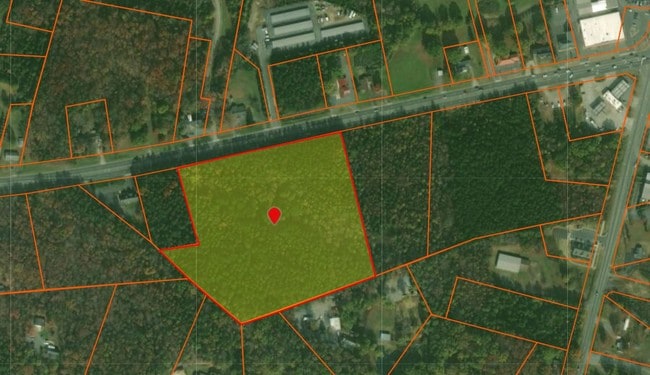
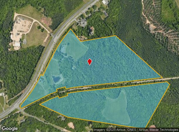
1451 Highway 24 27 W
5524-34-9781-0000
Hwy 24 27
Residentialacreage
BOTH SIDES HWY 24-27
X
Cabarrus
3710552400K
North Carolina
2025
97.39 AC
2025
Cabarrus County
041604
Charlotte
1,512 SF
Charlotte-Concord-Gastonia, NC-SC
DEMOGRAPHICS near 1451 Highway 24 27 W
1 Mile
3 Mile
5 Mile
2024 Total Population
1,962
6,437
17,848
2029 Population
2,247
7,287
19,844
Pop Growth 2024-2029
+ 14.53%
+ 13.20%
+ 11.18%
Average Age
38
39
41
2024 Total Households
705
2,320
6,646
HH Growth 2024-2029
+ 13.19%
+ 11.81%
+ 10.14%
Median Household Inc
$100,710
$104,571
$85,448
Avg Household Size
2.80
2.80
2.70
2024 Avg HH Vehicles
2.00
2.00
2.00
Median Home Value
$268,658
$277,375
$278,682
Median Year Built
2010
2002
1994
Nearby Places
Map Layers
Map Styles
 Street
 Aerial
- Restaurants
- Banks
- Shops
- Fitness
- Groceries
PUBLIC TRANSPORTATION
AIRPORT
Concord-Padgett Regional
DRIVE
WALK
Distance
Concord-Padgett Regional
25 min
18.3 mi
Charlotte/Douglas International
DRIVE
WALK
Distance
Charlotte/Douglas International
40 min
23.3 mi
Freight Ports
North Charleston Terminal
DRIVE
WALK
Distance
North Charleston Terminal
247 min
216.5 mi
SALE & LEASE HISTORY
LISTING DATE
SALE/LEASE

Dec 06, 2018
For Sale
Nearby Properties
Address
Land Use
TOTAL SIZE
Lot Size
Zoning
Address
Land Use
TOTAL SIZE
Lot Size
Zoning
290,268 SF
19.96 AC
R17MFCD
Address
Land Use
TOTAL SIZE
Lot Size
Zoning
239,983 SF
21.41 AC
I-G(CD)
Address
Land Use
TOTAL SIZE
Lot Size
Zoning
58,134 SF
5.08 AC
IGCUD
Address
Land Use
TOTAL SIZE
Lot Size
Zoning
104,214 SF
1.69 AC
MUDD-O
Address
Land Use
TOTAL SIZE
Lot Size
Zoning
62,619 SF
11.93 AC
I-G(CD)
Address
Land Use
TOTAL SIZE
Lot Size
Zoning
68,653 SF
17.30 AC
R3
Address
Land Use
TOTAL SIZE
Lot Size
Zoning
69,108 SF
14.95 AC
I-G(CD)
Address
Land Use
TOTAL SIZE
Lot Size
Zoning
3,614 SF
7.57 AC
NS
Address
Land Use
TOTAL SIZE
Lot Size
Zoning
54,051 SF
25.06 AC
CR
Address
Land Use
TOTAL SIZE
Lot Size
Zoning
92.46 AC
OM
Address
Land Use
TOTAL SIZE
Lot Size
Zoning
188.38 AC
R-3
Address
Land Use
TOTAL SIZE
Lot Size
Zoning
5,528 SF
174.55 AC
O-1
Address
Land Use
TOTAL SIZE
Lot Size
Zoning
37,502 SF
24.21 AC
R
Address
Land Use
TOTAL SIZE
Lot Size
Zoning
4.12 AC
I-G(CD)
Address
Land Use
TOTAL SIZE
Lot Size
Zoning
8,800 SF
4.72 AC
IND
Address
Land Use
TOTAL SIZE
Lot Size
Zoning
4,642 SF
2.01 AC
B-1(CD)
Address
Land Use
TOTAL SIZE
Lot Size
Zoning
9,470 SF
24.34 AC
IND
Address
Land Use
TOTAL SIZE
Lot Size
Zoning
1,471 SF
14.60 AC
NS
Address
Land Use
TOTAL SIZE
Lot Size
Zoning
4,326 SF
2.36 AC
B-G
Address
Land Use
TOTAL SIZE
Lot Size
Zoning
21,916 SF
3 AC
R
Address
Land Use
TOTAL SIZE
Lot Size
Zoning
17,282 SF
2.36 AC
Address
Land Use
TOTAL SIZE
Lot Size
Zoning
70.10 AC
IND
Address
Land Use
TOTAL SIZE
Lot Size
Zoning
23,840 SF
5.48 AC
I-G(CD)
Address
Land Use
TOTAL SIZE
Lot Size
Zoning
23,840 SF
3.07 AC
I-G(CD)
Address
Land Use
TOTAL SIZE
Lot Size
Zoning
6,641 SF
81.32 AC
R3
Address
Land Use
TOTAL SIZE
Lot Size
Zoning
98.83 AC
RL
Address
Land Use
TOTAL SIZE
Lot Size
Zoning
12,682 SF
8.46 AC
CR
Address
Land Use
TOTAL SIZE
Lot Size
Zoning
4,775 SF
1.44 AC
Address
Land Use
TOTAL SIZE
Lot Size
Zoning
The World's #1 Commercial Real Estate Marketplace
Connect with us
© 2026 CoStar Group
The information above has been obtained from sources believed reliable. While we do not doubt its accuracy we have not verified it and make no guarantee, warranty or representation about it. It is your responsibility to independently confirm its accuracy and completeness. Any projections, opinions, assumptions, or estimates used are for example only and do not represent the current or future performance of the property. The value of this transaction to you depends on tax and other factors which should be evaluated by your tax, financial, and legal advisors. You and your advisors should conduct a careful, independent investigation of the property to determine to your satisfaction the suitability of the property for your needs.