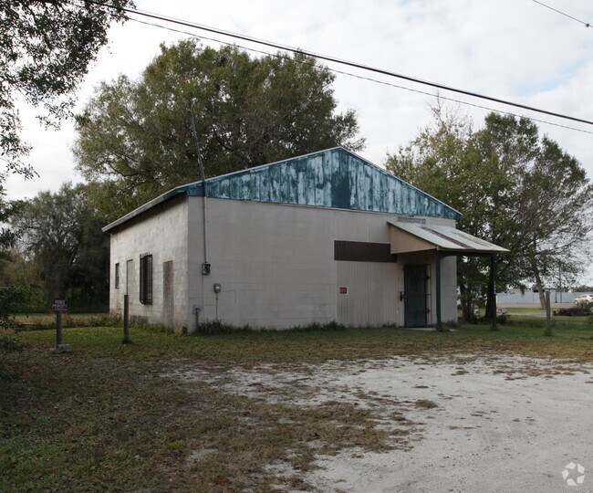
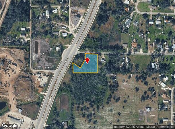
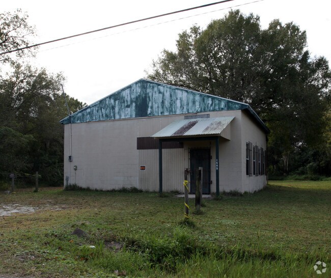
Property Record
1451 Sw Hillcrest St, Arcadia, FL 34266
NEARBY LISTINGS FOR SALE OR LEASE
Property Detail
1451 Sw Hillcrest St
Other Market Areas
Hillcrest
Arcadia, FL
HILLCREST LOTS 1 TO 6 INC LESS & EXCEPT COMM AT NE COR OF NW1/4 OF SEC 12-38-24 TH ALG E LI S 00D00M 41S E A DIST OF 971.25 FT TO SURVEY BASE LI TH ALG BASE LI S 30D26M18S W A DIST OF 162.79 FT TH S 88D56M21S E A DIST OF 82.51 FT TO NW COR OF SAID LO
12-38-24-0192-0000-0010
DeSoto
Vacantlandnec
Florida
2024
1
2024
1.15 AC
010301
Florida Central South Area
1,696 SF
DEMOGRAPHICS near 1451 Sw Hillcrest St
1 Mile
3 Mile
5 Mile
2024 Total Population
3,669
18,699
24,491
2029 Population
4,075
20,667
27,009
Pop Growth 2024-2029
+ 11.07%
+ 10.52%
+ 10.28%
Average Age
36
39
40
2024 Total Households
1,219
6,523
8,415
HH Growth 2024-2029
+ 11.98%
+ 11.36%
+ 11.27%
Median Household Inc
$38,903
$33,222
$34,813
Avg Household Size
3.00
2.80
2.70
2024 Avg HH Vehicles
2.00
2.00
2.00
Median Home Value
$97,142
$112,725
$117,031
Median Year Built
1982
1982
1984
Nearby Places
Map Layers
Map Styles
 Street
 Aerial
- Restaurants
- Banks
- Shops
- Fitness
- Groceries
PUBLIC TRANSPORTATION
AIRPORT
Punta Gorda
DRIVE
WALK
Distance
Punta Gorda
34 min
23.5 mi
Freight Ports
Port Manatee
DRIVE
WALK
Distance
Port Manatee
82 min
59.6 mi
Nearby Properties
Address
Land Use
TOTAL SIZE
Lot Size
Zoning
Address
Land Use
TOTAL SIZE
Lot Size
Zoning
67,387 SF
46.10 AC
PUD
Address
Land Use
TOTAL SIZE
Lot Size
Zoning
106,179 SF
12.48 AC
RPB
Address
Land Use
TOTAL SIZE
Lot Size
Zoning
182,809 SF
60 AC
A-5
Address
Land Use
TOTAL SIZE
Lot Size
Zoning
128,748 SF
21.47 AC
CG
Address
Land Use
TOTAL SIZE
Lot Size
Zoning
57,048 SF
20.25 AC
PUD
Address
Land Use
TOTAL SIZE
Lot Size
Zoning
7,911 SF
30 AC
TTRVC
Address
Land Use
TOTAL SIZE
Lot Size
Zoning
67,970 SF
8.24 AC
CG
Address
Land Use
TOTAL SIZE
Lot Size
Zoning
121,889 SF
9 AC
B-3
Address
Land Use
TOTAL SIZE
Lot Size
Zoning
67,407 SF
4.82 AC
R-1B
Address
Land Use
TOTAL SIZE
Lot Size
Zoning
83,273 SF
13.94 AC
ROI
Address
Land Use
TOTAL SIZE
Lot Size
Zoning
25,798 SF
5 AC
B-1A
Address
Land Use
TOTAL SIZE
Lot Size
Zoning
39,416 SF
2.29 AC
CG
Address
Land Use
TOTAL SIZE
Lot Size
Zoning
80,103 SF
11 AC
R-1B
Address
Land Use
TOTAL SIZE
Lot Size
Zoning
32,546 SF
45.40 AC
P/I
Address
Land Use
TOTAL SIZE
Lot Size
Zoning
53,740 SF
2.29 AC
R-1B
Address
Land Use
TOTAL SIZE
Lot Size
Zoning
45,985 SF
1.30 AC
B-2
Address
Land Use
TOTAL SIZE
Lot Size
Zoning
7,101 SF
30.89 AC
MHP
Address
Land Use
TOTAL SIZE
Lot Size
Zoning
40,614 SF
4.33 AC
R-3
Address
Land Use
TOTAL SIZE
Lot Size
Zoning
41,004 SF
4.67 AC
R-3
Address
Land Use
TOTAL SIZE
Lot Size
Zoning
54,644 SF
11.82 AC
PUD
Address
Land Use
TOTAL SIZE
Lot Size
Zoning
33.75 AC
PUD
Address
Land Use
TOTAL SIZE
Lot Size
Zoning
27,816 SF
3.67 AC
RMF-8
Address
Land Use
TOTAL SIZE
Lot Size
Zoning
48,488 SF
3.24 AC
B-2
Address
Land Use
TOTAL SIZE
Lot Size
Zoning
97,755 SF
9.20 AC
PUD
Address
Land Use
TOTAL SIZE
Lot Size
Zoning
21,108 SF
3.36 AC
A-5
Address
Land Use
TOTAL SIZE
Lot Size
Zoning
20,008 SF
4.69 AC
A-5
Address
Land Use
TOTAL SIZE
Lot Size
Zoning
32,256 SF
3.13 AC
R-4
Address
Land Use
TOTAL SIZE
Lot Size
Zoning
40,470 SF
3.99 AC
CG
Address
Land Use
TOTAL SIZE
Lot Size
Zoning
13,509 SF
1.93 AC
CG
Address
Land Use
TOTAL SIZE
Lot Size
Zoning
13,700 SF
2.39 AC
CG
The World's #1 Commercial Real Estate Marketplace
Connect with us
© 2025 CoStar Group
The information above has been obtained from sources believed reliable. While we do not doubt its accuracy we have not verified it and make no guarantee, warranty or representation about it. It is your responsibility to independently confirm its accuracy and completeness. Any projections, opinions, assumptions, or estimates used are for example only and do not represent the current or future performance of the property. The value of this transaction to you depends on tax and other factors which should be evaluated by your tax, financial, and legal advisors. You and your advisors should conduct a careful, independent investigation of the property to determine to your satisfaction the suitability of the property for your needs.