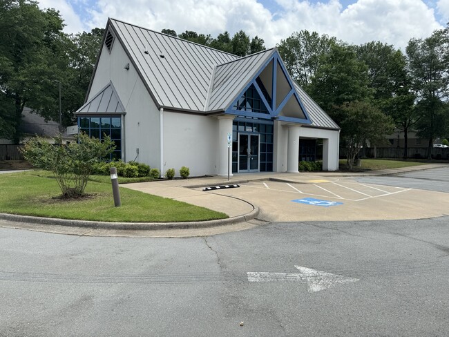
Property Record
14519 Cantrell Rd, Little Rock, AR 72223

Current Lease Availabilities
Property Detail
14519 Cantrell Rd
Little Rock-North Little Rock-Conway, AR
BEING A REPLAT OF LT'S 1,2 & 3 NOW REPLATTED AS LT 1R LESS AND EXCEPT: PART OF LOT 1-R OF A REPLAT OF HOGGARD'S SUBDIVISION, AN ADDITION TO THE CITY OF LITTLE ROCK AS FILED IN BOOK D, PAGE 401, LOCATED IN THE NORTHWEST QUARTER OF THE NORTHEAST QUAR
43L-008-12-001-00
Pulaski
Financialbuilding
Arkansas
B and X Area of moderate flood hazard, usually the area between the limits of the 100-year and 500-year floods.
1r
2025
0.80 AC
2025
West
004214
Little Rock/N Little Rock
1,788 SF
NEARBY LISTINGS FOR SALE OR LEASE
DEMOGRAPHICS near 14519 Cantrell Rd
1 mile
3 mile
5 mile
2025 Total Population
4,335
34,423
91,089
2030 Population
4,284
34,201
90,812
Pop Growth 2025-2030
(1.18%)
(0.64%)
(0.30%)
Average Age
41
41
40
2025 Total Households
1,755
14,425
40,193
HH Growth 2025-2030
(1.08%)
(0.53%)
(0.24%)
Median Household Inc
$108,456
$105,030
$86,105
Avg Household Size
2.40
2.30
2.20
2025 Avg HH Vehicles
2.00
2.00
2.00
Median Home Value
$350,413
$384,916
$334,789
Median Year Built
1992
1992
1991
Nearby Places
Map Layers
Map Styles
 Street
 Aerial
Layers
 Traffic
 Biking
Places
Listings with unknown addresses are not visible on the map
- Restaurants
- Banks
- Shops
- Fitness
- Groceries
PUBLIC TRANSPORTATION
AIRPORT
Bill and Hillary Clinton Ntl/Adams Field
Drive
Walk
Distance
Bill and Hillary Clinton Ntl/Adams Field
26 min
16.8 mi
Nearby Properties
Address
Land Use
TOTAL SIZE
Lot Size
Zoning
Address
Land Use
TOTAL SIZE
Lot Size
Zoning
361,360 SF
20.01 AC
Address
Land Use
TOTAL SIZE
Lot Size
Zoning
286,440 SF
10.79 AC
Address
Land Use
TOTAL SIZE
Lot Size
Zoning
126,536 SF
25.98 AC
Address
Land Use
TOTAL SIZE
Lot Size
Zoning
267,343 SF
52.19 AC
Address
Land Use
TOTAL SIZE
Lot Size
Zoning
201,059 SF
49.76 AC
Address
Land Use
TOTAL SIZE
Lot Size
Zoning
54,594 SF
16.79 AC
Address
Land Use
TOTAL SIZE
Lot Size
Zoning
216,869 SF
20.84 AC
Address
Land Use
TOTAL SIZE
Lot Size
Zoning
82,176 SF
14.83 AC
Address
Land Use
TOTAL SIZE
Lot Size
Zoning
43,928 SF
26.72 AC
Address
Land Use
TOTAL SIZE
Lot Size
Zoning
102,600 SF
17.29 AC
Address
Land Use
TOTAL SIZE
Lot Size
Zoning
125,107 SF
22.09 AC
Address
Land Use
TOTAL SIZE
Lot Size
Zoning
168,221 SF
12.02 AC
Address
Land Use
TOTAL SIZE
Lot Size
Zoning
32,562 SF
13.40 AC
Address
Land Use
TOTAL SIZE
Lot Size
Zoning
73,197 SF
12.09 AC
Address
Land Use
TOTAL SIZE
Lot Size
Zoning
293,057 SF
20.78 AC
Address
Land Use
TOTAL SIZE
Lot Size
Zoning
115,062 SF
10.04 AC
Address
Land Use
TOTAL SIZE
Lot Size
Zoning
86,186 SF
13.24 AC
Address
Land Use
TOTAL SIZE
Lot Size
Zoning
160,068 SF
18.91 AC
Address
Land Use
TOTAL SIZE
Lot Size
Zoning
114,269 SF
12.85 AC
Address
Land Use
TOTAL SIZE
Lot Size
Zoning
65,208 SF
18.30 AC
Address
Land Use
TOTAL SIZE
Lot Size
Zoning
122,775 SF
9.96 AC
Address
Land Use
TOTAL SIZE
Lot Size
Zoning
155,943 SF
10.59 AC
Address
Land Use
TOTAL SIZE
Lot Size
Zoning
217,088 SF
26.89 AC
Address
Land Use
TOTAL SIZE
Lot Size
Zoning
69,251 SF
24.10 AC
Address
Land Use
TOTAL SIZE
Lot Size
Zoning
40,803 SF
18.48 AC
Address
Land Use
TOTAL SIZE
Lot Size
Zoning
129,239 SF
9.01 AC
Address
Land Use
TOTAL SIZE
Lot Size
Zoning
30,040 SF
10.80 AC
Address
Land Use
TOTAL SIZE
Lot Size
Zoning
93,175 SF
4.74 AC
Address
Land Use
TOTAL SIZE
Lot Size
Zoning
123,661 SF
14.71 AC
Address
Land Use
TOTAL SIZE
Lot Size
Zoning
63,140 SF
14.22 AC
The World's #1 Commercial Real Estate Marketplace
Connect with us
© 2026 CoStar Group
The information above has been obtained from sources believed reliable. While we do not doubt its accuracy we have not verified it and make no guarantee, warranty or representation about it. It is your responsibility to independently confirm its accuracy and completeness. Any projections, opinions, assumptions, or estimates used are for example only and do not represent the current or future performance of the property. The value of this transaction to you depends on tax and other factors which should be evaluated by your tax, financial, and legal advisors. You and your advisors should conduct a careful, independent investigation of the property to determine to your satisfaction the suitability of the property for your needs.