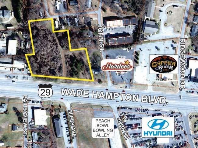
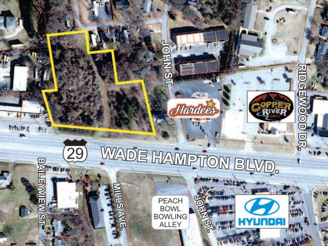
Property Record
14520 E Wade Hampton Blvd, Greer, SC 29651
NEARBY LISTINGS FOR SALE OR LEASE
Property Detail
14520 E Wade Hampton Blvd
Spartanburg, SC
Property Of Frank Mcelrath
9-03-09-008.00
P/O LOT 90 & 91 EMMA CANNON SUB & ADJ TR DB 56L-427 DB 133N-353 DB 50E-979 DB 45P-259 PB 26-488-491
Vacantlandnec
Spartanburg
ARE
South Carolina
45045C0353F
90,91
2024
0.82 AC
2025
Upper Spartanburg County
002505
Greenville/Spartanburg
DEMOGRAPHICS near 14520 E Wade Hampton Blvd
1 mile
3 mile
5 mile
2024 Total Population
6,045
35,533
79,326
2029 Population
6,776
39,697
88,509
Pop Growth 2024-2029
+ 12.09%
+ 11.72%
+ 11.58%
Average Age
39
39
39
2024 Total Households
2,570
14,397
30,860
HH Growth 2024-2029
+ 12.22%
+ 11.79%
+ 11.67%
Median Household Inc
$51,230
$53,837
$65,791
Avg Household Size
2.30
2.40
2.50
2024 Avg HH Vehicles
2.00
2.00
2.00
Median Home Value
$160,102
$196,549
$226,491
Median Year Built
1980
1990
1995
Nearby Places
Map Layers
Map Styles
 Street
 Aerial
Transit
 Traffic
 Biking
Places
Listings with unknown addresses are not visible on the map
- Restaurants
- Banks
- Shops
- Fitness
- Groceries
PUBLIC TRANSPORTATION
AIRPORT
Greenville Spartanburg International
Drive
Walk
Distance
Greenville Spartanburg International
8 min
4.4 mi
Asheville Regional
Drive
Walk
Distance
Asheville Regional
67 min
48.7 mi
SALE & LEASE HISTORY
LISTING DATE
SALE/LEASE

Sep 24, 2016
For Sale
Aug 15, 2017
For Sale
Aug 13, 2019
For Sale
Nearby Properties
Address
Land Use
TOTAL SIZE
Lot Size
Zoning
Address
Land Use
TOTAL SIZE
Lot Size
Zoning
227,627 SF
21.37 AC
Address
Land Use
TOTAL SIZE
Lot Size
Zoning
14.20 AC
UNZONED
Address
Land Use
TOTAL SIZE
Lot Size
Zoning
532 SF
72.61 AC
I1
Address
Land Use
TOTAL SIZE
Lot Size
Zoning
13.25 AC
I1
Address
Land Use
TOTAL SIZE
Lot Size
Zoning
5.07 AC
C2
Address
Land Use
TOTAL SIZE
Lot Size
Zoning
8.30 AC
RM
Address
Land Use
TOTAL SIZE
Lot Size
Zoning
0.42 AC
OD
Address
Land Use
TOTAL SIZE
Lot Size
Zoning
99.01 AC
I1
Address
Land Use
TOTAL SIZE
Lot Size
Zoning
14.33 AC
I1
Address
Land Use
TOTAL SIZE
Lot Size
Zoning
48.84 AC
C2
Address
Land Use
TOTAL SIZE
Lot Size
Zoning
8.22 AC
I1
Address
Land Use
TOTAL SIZE
Lot Size
Zoning
1.05 AC
S1
Address
Land Use
TOTAL SIZE
Lot Size
Zoning
6.81 AC
RM
Address
Land Use
TOTAL SIZE
Lot Size
Zoning
1.90 AC
I1
Address
Land Use
TOTAL SIZE
Lot Size
Zoning
10.20 AC
S1
Address
Land Use
TOTAL SIZE
Lot Size
Zoning
5.23 AC
I1
Address
Land Use
TOTAL SIZE
Lot Size
Zoning
5.15 AC
R15
Address
Land Use
TOTAL SIZE
Lot Size
Zoning
12.91 AC
RM
Address
Land Use
TOTAL SIZE
Lot Size
Zoning
11.70 AC
C2
Address
Land Use
TOTAL SIZE
Lot Size
Zoning
2.15 AC
C2
Address
Land Use
TOTAL SIZE
Lot Size
Zoning
2,666 SF
1.57 AC
R15
Address
Land Use
TOTAL SIZE
Lot Size
Zoning
0.51 AC
C1
Address
Land Use
TOTAL SIZE
Lot Size
Zoning
1.15 AC
C1
Address
Land Use
TOTAL SIZE
Lot Size
Zoning
4.07 AC
OD
Address
Land Use
TOTAL SIZE
Lot Size
Zoning
6.90 AC
I1
Address
Land Use
TOTAL SIZE
Lot Size
Zoning
710,705 SF
34.03 AC
Address
Land Use
TOTAL SIZE
Lot Size
Zoning
91,927 SF
21.14 AC
Address
Land Use
TOTAL SIZE
Lot Size
Zoning
16,592 SF
15.43 AC
Address
Land Use
TOTAL SIZE
Lot Size
Zoning
34.30 AC
UNZONED
Address
Land Use
TOTAL SIZE
Lot Size
Zoning
7.12 AC
R15
The World's #1 Commercial Real Estate Marketplace
Connect with us
© 2026 CoStar Group
The information above has been obtained from sources believed reliable. While we do not doubt its accuracy we have not verified it and make no guarantee, warranty or representation about it. It is your responsibility to independently confirm its accuracy and completeness. Any projections, opinions, assumptions, or estimates used are for example only and do not represent the current or future performance of the property. The value of this transaction to you depends on tax and other factors which should be evaluated by your tax, financial, and legal advisors. You and your advisors should conduct a careful, independent investigation of the property to determine to your satisfaction the suitability of the property for your needs.