Property Record
14522 N Cheshire St, Burton, OH 44021
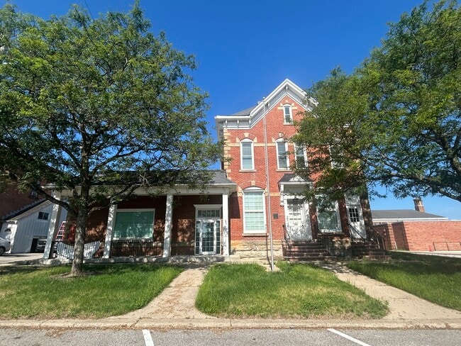


Property Detail
14522 N Cheshire St
05-012500
LOT 35 & 20 PARCEL #1
Financialbuilding
GEAUGA
B1
Ohio
B and X Area of moderate flood hazard, usually the area between the limits of the 100-year and 500-year floods.
20,35
2025
0.27 AC
2025
Geauga County
311300
Cleveland
10,375 SF
Cleveland-Elyria, OH
NEARBY LISTINGS FOR SALE OR LEASE
-
-
View all Burton listings for lease on LoopNet.com
DEMOGRAPHICS near 14522 N Cheshire St
1 mile
3 mile
5 mile
2025 Total Population
1,474
4,767
15,313
2030 Population
1,426
4,694
15,194
Pop Growth 2025-2030
(3.26%)
(1.53%)
(0.78%)
Average Age
43
42
41
2025 Total Households
612
1,815
5,721
HH Growth 2025-2030
(3.59%)
(1.65%)
(0.86%)
Median Household Inc
$65,560
$80,307
$79,290
Avg Household Size
2.30
2.50
2.60
2025 Avg HH Vehicles
2.00
2.00
2.00
Median Home Value
$236,423
$254,417
$251,495
Median Year Built
1951
1962
1971
Nearby Places
Map Layers
Map Styles
 Street
 Aerial
Layers
 Traffic
 Biking
Places
Listings with unknown addresses are not visible on the map
- Restaurants
- Banks
- Shops
- Fitness
- Groceries
SALE & LEASE HISTORY
LISTING DATE
SALE/LEASE

Jul 10, 2025
For Lease
Jan 17, 2025
For Sale
Feb 13, 2023
For Lease
Nearby Properties
Address
Land Use
TOTAL SIZE
Lot Size
Zoning
Address
Land Use
TOTAL SIZE
Lot Size
Zoning
35,614 SF
87.48 AC
R5
Address
Land Use
TOTAL SIZE
Lot Size
Zoning
4,664 SF
13.24 AC
Address
Land Use
TOTAL SIZE
Lot Size
Zoning
36,908 SF
15 AC
Address
Land Use
TOTAL SIZE
Lot Size
Zoning
68,900 SF
18.18 AC
IC
Address
Land Use
TOTAL SIZE
Lot Size
Zoning
1,156 SF
271.45 AC
OCF
Address
Land Use
TOTAL SIZE
Lot Size
Zoning
1,978 SF
19.31 AC
Address
Land Use
TOTAL SIZE
Lot Size
Zoning
28,789 SF
2.69 AC
S1
Address
Land Use
TOTAL SIZE
Lot Size
Zoning
6,148 SF
9.12 AC
R3
Address
Land Use
TOTAL SIZE
Lot Size
Zoning
9,636 SF
14 AC
IC
Address
Land Use
TOTAL SIZE
Lot Size
Zoning
4,640 SF
4.72 AC
R3
Address
Land Use
TOTAL SIZE
Lot Size
Zoning
31,826 SF
19.11 AC
IC
Address
Land Use
TOTAL SIZE
Lot Size
Zoning
43,500 SF
16.71 AC
INST
Address
Land Use
TOTAL SIZE
Lot Size
Zoning
1,844 SF
17.77 AC
M1
Address
Land Use
TOTAL SIZE
Lot Size
Zoning
38,445 SF
3.26 AC
R1
Address
Land Use
TOTAL SIZE
Lot Size
Zoning
1,342 SF
39.72 AC
R5
Address
Land Use
TOTAL SIZE
Lot Size
Zoning
47,183 SF
7.70 AC
GC
Address
Land Use
TOTAL SIZE
Lot Size
Zoning
29,440 SF
5.10 AC
B2
Address
Land Use
TOTAL SIZE
Lot Size
Zoning
5,578 SF
18.37 AC
Address
Land Use
TOTAL SIZE
Lot Size
Zoning
44,750 SF
3.02 AC
GC
Address
Land Use
TOTAL SIZE
Lot Size
Zoning
702 SF
11.52 AC
Address
Land Use
TOTAL SIZE
Lot Size
Zoning
7,445 SF
113.68 AC
R5
Address
Land Use
TOTAL SIZE
Lot Size
Zoning
4,524 SF
161.76 AC
INST
Address
Land Use
TOTAL SIZE
Lot Size
Zoning
40,200 SF
3.45 AC
IC
Address
Land Use
TOTAL SIZE
Lot Size
Zoning
5,904 SF
4.07 AC
R5
Address
Land Use
TOTAL SIZE
Lot Size
Zoning
32,584 SF
3.24 AC
IC
Address
Land Use
TOTAL SIZE
Lot Size
Zoning
54,810 SF
11.67 AC
Address
Land Use
TOTAL SIZE
Lot Size
Zoning
17,731 SF
3 AC
Address
Land Use
TOTAL SIZE
Lot Size
Zoning
8,980 SF
6.55 AC
B1
Address
Land Use
TOTAL SIZE
Lot Size
Zoning
6,876 SF
4.25 AC
IC
Address
Land Use
TOTAL SIZE
Lot Size
Zoning
15,196 SF
5 AC
M2
The World's #1 Commercial Real Estate Marketplace
Connect with us
© 2026 CoStar Group
The information above has been obtained from sources believed reliable. While we do not doubt its accuracy we have not verified it and make no guarantee, warranty or representation about it. It is your responsibility to independently confirm its accuracy and completeness. Any projections, opinions, assumptions, or estimates used are for example only and do not represent the current or future performance of the property. The value of this transaction to you depends on tax and other factors which should be evaluated by your tax, financial, and legal advisors. You and your advisors should conduct a careful, independent investigation of the property to determine to your satisfaction the suitability of the property for your needs.