Property Record
14522 W Lawyers Rd, Matthews, NC 28104

NEARBY LISTINGS FOR SALE OR LEASE
-
-
View all Matthews listings for sale on LoopNet.com
Property Detail
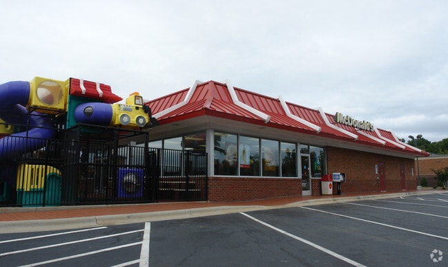
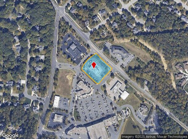
14522 W Lawyers Rd
Charlotte-Concord-Gastonia, NC-SC
Stevens Mill Crossing
07-054-715-C
#3 STEVENS MILL CROSSING LAWYERS RD
Restaurantdrivein
Union
X
North Carolina
3710551100L
3
2025
1.23 AC
2025
Union County
020314
Charlotte
4,235 SF
DEMOGRAPHICS near 14522 W Lawyers Rd
1 Mile
3 Mile
5 Mile
2024 Total Population
4,478
24,482
75,278
2029 Population
5,001
26,880
82,248
Pop Growth 2024-2029
+ 11.68%
+ 9.79%
+ 9.26%
Average Age
44
42
41
2024 Total Households
1,678
8,643
27,066
HH Growth 2024-2029
+ 11.80%
+ 9.87%
+ 9.29%
Median Household Inc
$113,436
$104,090
$92,531
Avg Household Size
2.70
2.80
2.70
2024 Avg HH Vehicles
3.00
2.00
2.00
Median Home Value
$355,840
$365,565
$329,770
Median Year Built
1996
1998
1997
Nearby Places
Map Layers
Map Styles
 Street
 Aerial
- Restaurants
- Banks
- Shops
- Fitness
- Groceries
PUBLIC TRANSPORTATION
AIRPORT
Concord-Padgett Regional
DRIVE
WALK
Distance
Concord-Padgett Regional
27 min
20.9 mi
Charlotte/Douglas International
DRIVE
WALK
Distance
Charlotte/Douglas International
39 min
25.0 mi
Nearby Properties
Address
Land Use
TOTAL SIZE
Lot Size
Zoning
Address
Land Use
TOTAL SIZE
Lot Size
Zoning
78,372 SF
14.08 AC
IGCUD
Address
Land Use
TOTAL SIZE
Lot Size
Zoning
86,432 SF
20.01 AC
I
Address
Land Use
TOTAL SIZE
Lot Size
Zoning
40,890 SF
2.92 AC
O-A DO-B(C
Address
Land Use
TOTAL SIZE
Lot Size
Zoning
80,888 SF
8.20 AC
Address
Land Use
TOTAL SIZE
Lot Size
Zoning
36,480 SF
12.21 AC
NRD STALLI
Address
Land Use
TOTAL SIZE
Lot Size
Zoning
67,080 SF
7.99 AC
Address
Land Use
TOTAL SIZE
Lot Size
Zoning
52,747 SF
8.05 AC
GR STALLIN
Address
Land Use
TOTAL SIZE
Lot Size
Zoning
45,974 SF
9.85 AC
O-A DO-B(C
Address
Land Use
TOTAL SIZE
Lot Size
Zoning
73,255 SF
13.35 AC
R
Address
Land Use
TOTAL SIZE
Lot Size
Zoning
36,731 SF
7.01 AC
GBD INDIAN
Address
Land Use
TOTAL SIZE
Lot Size
Zoning
9,762 SF
134.77 AC
R-15 STALL
Address
Land Use
TOTAL SIZE
Lot Size
Zoning
21,934 SF
16.22 AC
RA-40 UNIO
Address
Land Use
TOTAL SIZE
Lot Size
Zoning
43,843 SF
30 AC
SF-1 INDIA
Address
Land Use
TOTAL SIZE
Lot Size
Zoning
10,036 SF
4.72 AC
GR STALLIN
Address
Land Use
TOTAL SIZE
Lot Size
Zoning
21,001 SF
20.22 AC
R
Address
Land Use
TOTAL SIZE
Lot Size
Zoning
54,308 SF
7.54 AC
BPCUD
Address
Land Use
TOTAL SIZE
Lot Size
Zoning
20,808 SF
1.56 AC
B-D DO-B
Address
Land Use
TOTAL SIZE
Lot Size
Zoning
10,852 SF
10.64 AC
BG
Address
Land Use
TOTAL SIZE
Lot Size
Zoning
12,052 SF
2.12 AC
B-G DO-B(C
Address
Land Use
TOTAL SIZE
Lot Size
Zoning
20,903 SF
1.49 AC
Address
Land Use
TOTAL SIZE
Lot Size
Zoning
25,695 SF
2.45 AC
B-G DO-B
Address
Land Use
TOTAL SIZE
Lot Size
Zoning
37,224 SF
5.54 AC
IGCUD
Address
Land Use
TOTAL SIZE
Lot Size
Zoning
18,236 SF
2 AC
R
Address
Land Use
TOTAL SIZE
Lot Size
Zoning
15,255 SF
1.87 AC
R DO-A
Address
Land Use
TOTAL SIZE
Lot Size
Zoning
9,969 SF
1.70 AC
B-G DO-B
Address
Land Use
TOTAL SIZE
Lot Size
Zoning
28,720 SF
5.37 AC
B-G DO-B
Address
Land Use
TOTAL SIZE
Lot Size
Zoning
8,350 SF
4.04 AC
R DO-A
Address
Land Use
TOTAL SIZE
Lot Size
Zoning
20,125 SF
2.92 AC
R
Address
Land Use
TOTAL SIZE
Lot Size
Zoning
6,326 SF
93.72 AC
R-15 STALL
Address
Land Use
TOTAL SIZE
Lot Size
Zoning
8,280 SF
1.16 AC
B-G DO-B(C
The World's #1 Commercial Real Estate Marketplace
Connect with us
© 2026 CoStar Group
The information above has been obtained from sources believed reliable. While we do not doubt its accuracy we have not verified it and make no guarantee, warranty or representation about it. It is your responsibility to independently confirm its accuracy and completeness. Any projections, opinions, assumptions, or estimates used are for example only and do not represent the current or future performance of the property. The value of this transaction to you depends on tax and other factors which should be evaluated by your tax, financial, and legal advisors. You and your advisors should conduct a careful, independent investigation of the property to determine to your satisfaction the suitability of the property for your needs.