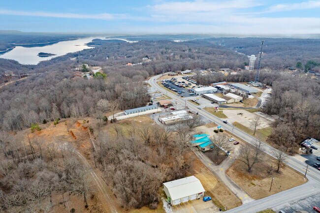
Property Record
14528 E Highway 12, Rogers, AR 72756
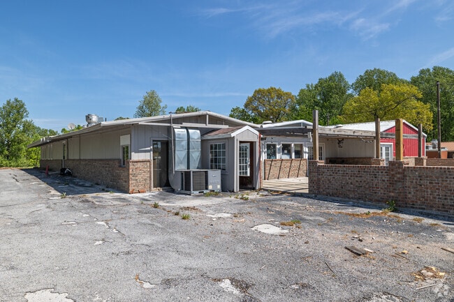

This Property Is For Sale
Property Detail
14528 E Highway 12
18-03130-000
A PART OF THE W1/2 OF THE SW1/4 OF SECTION 3, TOWNSHIP 19 NORTH, RANGE 29 WEST, BENTON COUNTY, ARKANSAS MORE PARTICULARLY DESCRIBED AS: COMMENCING AT THE SW CORNER OF THE NW1/4 SW1/4 OF SAID SECTION 3; THENCE NORTH 150.00 FEET; THENCE EAST 701.83 FEE
Bartavern
Benton
B and X Area of moderate flood hazard, usually the area between the limits of the 100-year and 500-year floods.
Arkansas
2025
1.20 AC
2025
Outlying Benton County
021407
Fayetteville/Springdale/Rogers
6,122 SF
Fayetteville-Springdale-Rogers, AR
NEARBY LISTINGS FOR SALE OR LEASE
-
-
View all Rogers listings for sale on LoopNet.com
DEMOGRAPHICS near 14528 E Highway 12
1 mile
3 mile
5 mile
2025 Total Population
1,936
11,085
51,500
2030 Population
2,129
12,317
56,883
Pop Growth 2025-2030
+ 9.97%
+ 11.11%
+ 10.45%
Average Age
46
42
38
2025 Total Households
784
4,131
18,200
HH Growth 2025-2030
+ 10.20%
+ 11.38%
+ 10.81%
Median Household Inc
$103,209
$90,919
$71,895
Avg Household Size
2.50
2.60
2.70
2025 Avg HH Vehicles
2.00
2.00
2.00
Median Home Value
$456,830
$440,993
$318,160
Median Year Built
1992
1993
1991
Nearby Places
Map Layers
Map Styles
 Street
 Aerial
Layers
 Traffic
 Biking
Places
Listings with unknown addresses are not visible on the map
- Restaurants
- Banks
- Shops
- Fitness
- Groceries
PUBLIC TRANSPORTATION
AIRPORT
Northwest Arkansas Ntl
Drive
Walk
Distance
Northwest Arkansas Ntl
39 min
18.9 mi
Nearby Properties
Address
Land Use
TOTAL SIZE
Lot Size
Zoning
Address
Land Use
TOTAL SIZE
Lot Size
Zoning
3,531 SF
0.02 AC
Address
Land Use
TOTAL SIZE
Lot Size
Zoning
21,482 SF
3.90 AC
Address
Land Use
TOTAL SIZE
Lot Size
Zoning
47,580 SF
17.60 AC
Address
Land Use
TOTAL SIZE
Lot Size
Zoning
35,700 SF
5.63 AC
Address
Land Use
TOTAL SIZE
Lot Size
Zoning
54,220 SF
7.46 AC
Address
Land Use
TOTAL SIZE
Lot Size
Zoning
14,000 SF
3.99 AC
Address
Land Use
TOTAL SIZE
Lot Size
Zoning
10,400 SF
69 AC
Address
Land Use
TOTAL SIZE
Lot Size
Zoning
8,491 SF
19.82 AC
Address
Land Use
TOTAL SIZE
Lot Size
Zoning
47,624 SF
4.91 AC
Address
Land Use
TOTAL SIZE
Lot Size
Zoning
26,670 SF
3.23 AC
Address
Land Use
TOTAL SIZE
Lot Size
Zoning
40,615 SF
6.58 AC
Address
Land Use
TOTAL SIZE
Lot Size
Zoning
2,552 SF
0.08 AC
Address
Land Use
TOTAL SIZE
Lot Size
Zoning
8,000 SF
1.75 AC
Address
Land Use
TOTAL SIZE
Lot Size
Zoning
20,329 SF
4.54 AC
Address
Land Use
TOTAL SIZE
Lot Size
Zoning
4,976 SF
0.79 AC
Address
Land Use
TOTAL SIZE
Lot Size
Zoning
4,633 SF
1.06 AC
Address
Land Use
TOTAL SIZE
Lot Size
Zoning
13,218 SF
1.19 AC
Address
Land Use
TOTAL SIZE
Lot Size
Zoning
12,151 SF
1.08 AC
Address
Land Use
TOTAL SIZE
Lot Size
Zoning
8,160 SF
8.24 AC
Address
Land Use
TOTAL SIZE
Lot Size
Zoning
16,000 SF
1.18 AC
Address
Land Use
TOTAL SIZE
Lot Size
Zoning
4,190 SF
1.04 AC
Address
Land Use
TOTAL SIZE
Lot Size
Zoning
16,672 SF
1.83 AC
Address
Land Use
TOTAL SIZE
Lot Size
Zoning
5,224 SF
0.84 AC
Address
Land Use
TOTAL SIZE
Lot Size
Zoning
11,796 SF
2.61 AC
Address
Land Use
TOTAL SIZE
Lot Size
Zoning
26,764 SF
7.43 AC
Address
Land Use
TOTAL SIZE
Lot Size
Zoning
4,652 SF
1 AC
Address
Land Use
TOTAL SIZE
Lot Size
Zoning
2,280 SF
17.35 AC
Address
Land Use
TOTAL SIZE
Lot Size
Zoning
9,196 SF
1.52 AC
Address
Land Use
TOTAL SIZE
Lot Size
Zoning
4,800 SF
Address
Land Use
TOTAL SIZE
Lot Size
Zoning
25,104 SF
2.60 AC
The World's #1 Commercial Real Estate Marketplace
Connect with us
© 2026 CoStar Group
The information above has been obtained from sources believed reliable. While we do not doubt its accuracy we have not verified it and make no guarantee, warranty or representation about it. It is your responsibility to independently confirm its accuracy and completeness. Any projections, opinions, assumptions, or estimates used are for example only and do not represent the current or future performance of the property. The value of this transaction to you depends on tax and other factors which should be evaluated by your tax, financial, and legal advisors. You and your advisors should conduct a careful, independent investigation of the property to determine to your satisfaction the suitability of the property for your needs.