Property Record
1453 W Mountain View Ave, Caruthers, CA 93609
NEARBY LISTINGS FOR SALE OR LEASE
-
-
View all Caruthers listings for sale on LoopNet.com
Property Detail
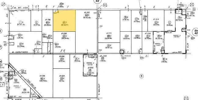
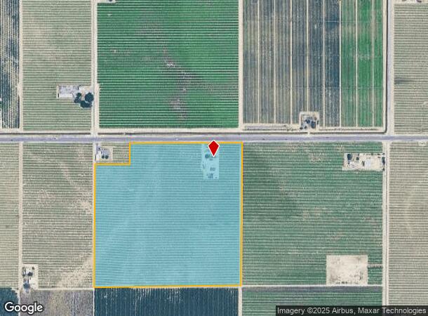
1453 W Mountain View Ave
043-020-83S
SUR RT 38.62 AC IN NW1/4 OF NE1/4 SEC 17 T16R20
Vineyard
Fresno
X
California
06019C2625H
38.62 AC
2025
W Outlying Fresno County
2025
Fresno
007500
Fresno, CA
1,120 SF
DEMOGRAPHICS near 1453 W Mountain View Ave
1 Mile
3 Mile
5 Mile
2024 Total Population
334
3,639
6,670
2029 Population
318
3,507
6,420
Pop Growth 2024-2029
(4.79%)
(3.63%)
(3.75%)
Average Age
37
35
35
2024 Total Households
92
978
1,813
HH Growth 2024-2029
(4.35%)
(3.58%)
(3.81%)
Median Household Inc
$62,045
$59,578
$58,656
Avg Household Size
3.40
3.50
3.40
2024 Avg HH Vehicles
3.00
2.00
2.00
Median Home Value
$299,999
$273,366
$290,202
Median Year Built
1958
1967
1968
Nearby Places
Map Layers
Map Styles
 Street
 Aerial
- Restaurants
- Banks
- Shops
- Fitness
- Groceries
PUBLIC TRANSPORTATION
AIRPORT
Fresno Yosemite International
DRIVE
WALK
Distance
Fresno Yosemite International
28 min
20.4 mi
Freight Ports
Port of Stockton
DRIVE
WALK
Distance
Port of Stockton
168 min
141.7 mi
Nearby Properties
Address
Land Use
TOTAL SIZE
Lot Size
Zoning
Address
Land Use
TOTAL SIZE
Lot Size
Zoning
143,752 SF
35.91 AC
AE20
Address
Land Use
TOTAL SIZE
Lot Size
Zoning
150,670 SF
13.86 AC
AE20
Address
Land Use
TOTAL SIZE
Lot Size
Zoning
1,600 SF
77.29 AC
AE20
Address
Land Use
TOTAL SIZE
Lot Size
Zoning
1,184 SF
77.36 AC
AE20
Address
Land Use
TOTAL SIZE
Lot Size
Zoning
3,011 SF
75 AC
AE20
Address
Land Use
TOTAL SIZE
Lot Size
Zoning
34,921 SF
3.07 AC
R2A
Address
Land Use
TOTAL SIZE
Lot Size
Zoning
26.22 AC
Address
Land Use
TOTAL SIZE
Lot Size
Zoning
819 SF
20 AC
AE20
Address
Land Use
TOTAL SIZE
Lot Size
Zoning
5,080 SF
32.88 AC
AE20
Address
Land Use
TOTAL SIZE
Lot Size
Zoning
21,700 SF
37.62 AC
M2
Address
Land Use
TOTAL SIZE
Lot Size
Zoning
8,972 SF
10 AC
AE20
Address
Land Use
TOTAL SIZE
Lot Size
Zoning
9,100 SF
2.07 AC
MI
Address
Land Use
TOTAL SIZE
Lot Size
Zoning
831 SF
160 AC
AE20
Address
Land Use
TOTAL SIZE
Lot Size
Zoning
8,236 SF
4.35 AC
C6
Address
Land Use
TOTAL SIZE
Lot Size
Zoning
3,164 SF
60.09 AC
AE20
Address
Land Use
TOTAL SIZE
Lot Size
Zoning
57.96 AC
AE20
Address
Land Use
TOTAL SIZE
Lot Size
Zoning
2,070 SF
38.80 AC
AE20
Address
Land Use
TOTAL SIZE
Lot Size
Zoning
38.59 AC
Address
Land Use
TOTAL SIZE
Lot Size
Zoning
1,613 SF
143.72 AC
AE20
Address
Land Use
TOTAL SIZE
Lot Size
Zoning
1,000 SF
20 AC
AE20
Address
Land Use
TOTAL SIZE
Lot Size
Zoning
7,844 SF
3.05 AC
R1
Address
Land Use
TOTAL SIZE
Lot Size
Zoning
1,904 SF
47.20 AC
AE20
Address
Land Use
TOTAL SIZE
Lot Size
Zoning
13,322 SF
1.55 AC
C4
Address
Land Use
TOTAL SIZE
Lot Size
Zoning
1,847 SF
52.50 AC
AE20
Address
Land Use
TOTAL SIZE
Lot Size
Zoning
1,200 SF
160 AC
AE20
Address
Land Use
TOTAL SIZE
Lot Size
Zoning
1,164 SF
155.20 AC
AE20
Address
Land Use
TOTAL SIZE
Lot Size
Zoning
2,223 SF
65.69 AC
AE20
Address
Land Use
TOTAL SIZE
Lot Size
Zoning
1,560 SF
49.09 AC
AE20
Address
Land Use
TOTAL SIZE
Lot Size
Zoning
1,685 SF
41.90 AC
AE20
The World's #1 Commercial Real Estate Marketplace
Connect with us
© 2026 CoStar Group
The information above has been obtained from sources believed reliable. While we do not doubt its accuracy we have not verified it and make no guarantee, warranty or representation about it. It is your responsibility to independently confirm its accuracy and completeness. Any projections, opinions, assumptions, or estimates used are for example only and do not represent the current or future performance of the property. The value of this transaction to you depends on tax and other factors which should be evaluated by your tax, financial, and legal advisors. You and your advisors should conduct a careful, independent investigation of the property to determine to your satisfaction the suitability of the property for your needs.