Property Record
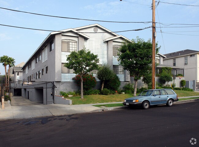
14533 Freeman Ave, Lawndale, CA 90260


Property Detail
14533 Freeman Ave
4077-011-023
LAWNDALE ACRES N 36 FT OF LOT 12 AND S 60 FT OF LOT 13 BLK 29
Multifamilydwelling
LOS ANGELES
LNR3*
California
B and X Area of moderate flood hazard, usually the area between the limits of the 100-year and 500-year floods.
12,13
2024
0.40 AC
2025
Lawndale
603902
Los Angeles
18,274 SF
Los Angeles-Long Beach-Glendale, CA
NEARBY LISTINGS FOR SALE OR LEASE
DEMOGRAPHICS near 14533 Freeman Ave
1 mile
3 mile
5 mile
2025 Total Population
51,455
287,250
630,185
2030 Population
51,166
284,315
625,138
Pop Growth 2025-2030
(0.56%)
(1.02%)
(0.80%)
Average Age
38
40
40
2025 Total Households
17,033
97,659
220,166
HH Growth 2025-2030
(0.70%)
(1.21%)
(0.94%)
Median Household Inc
$79,211
$91,307
$92,752
Avg Household Size
2.90
2.90
2.80
2025 Avg HH Vehicles
2.00
2.00
2.00
Median Home Value
$778,051
$874,261
$904,680
Median Year Built
1966
1963
1962
Nearby Places
Map Layers
Map Styles
 Street
 Aerial
Layers
 Traffic
 Biking
Places
Listings with unknown addresses are not visible on the map
- Restaurants
- Banks
- Shops
- Fitness
- Groceries
PUBLIC TRANSPORTATION
AIRPORT
Los Angeles International
Drive
Walk
Distance
Los Angeles International
13 min
7.0 mi
Long Beach (Daugherty Field)
Drive
Walk
Distance
Long Beach (Daugherty Field)
20 min
14.5 mi
Bob Hope
Drive
Walk
Distance
Bob Hope
42 min
30.6 mi
Freight Ports
Port of Los Angeles
Drive
Walk
Distance
Port of Los Angeles
28 min
17.7 mi
Nearby Properties
Address
Land Use
TOTAL SIZE
Lot Size
Zoning
Address
Land Use
TOTAL SIZE
Lot Size
Zoning
1,807,845 SF
7.28 AC
ESC3
Address
Land Use
TOTAL SIZE
Lot Size
Zoning
584,746 SF
20.38 AC
MNIP
Address
Land Use
TOTAL SIZE
Lot Size
Zoning
1,315,931 SF
3.36 AC
ESC3
Address
Land Use
TOTAL SIZE
Lot Size
Zoning
337,106 SF
9.56 AC
ESCM*
Address
Land Use
TOTAL SIZE
Lot Size
Zoning
944,791 SF
22.53 AC
ESCM*
Address
Land Use
TOTAL SIZE
Lot Size
Zoning
421,934 SF
8.24 AC
ESCM
Address
Land Use
TOTAL SIZE
Lot Size
Zoning
459,058 SF
8.84 AC
ESC3*
Address
Land Use
TOTAL SIZE
Lot Size
Zoning
718,086 SF
41.24 AC
RBI-1A
Address
Land Use
TOTAL SIZE
Lot Size
Zoning
418,131 SF
3.03 AC
LCC1
Address
Land Use
TOTAL SIZE
Lot Size
Zoning
848,217 SF
36.09 AC
RBI-1A
Address
Land Use
TOTAL SIZE
Lot Size
Zoning
1,410,144 SF
6.35 AC
ESM2*
Address
Land Use
TOTAL SIZE
Lot Size
Zoning
189,244 SF
3.64 AC
ESCM*
Address
Land Use
TOTAL SIZE
Lot Size
Zoning
319,589 SF
5.13 AC
MNPD
Address
Land Use
TOTAL SIZE
Lot Size
Zoning
227,596 SF
14.38 AC
HAM1YY
Address
Land Use
TOTAL SIZE
Lot Size
Zoning
1,972,924 SF
ESCM*
Address
Land Use
TOTAL SIZE
Lot Size
Zoning
448,818 SF
2.69 AC
ESC3*
Address
Land Use
TOTAL SIZE
Lot Size
Zoning
120,484 SF
11.63 AC
ESM2*
Address
Land Use
TOTAL SIZE
Lot Size
Zoning
307,559 SF
5.96 AC
ESC3
Address
Land Use
TOTAL SIZE
Lot Size
Zoning
279,694 SF
3.19 AC
LCR1*
Address
Land Use
TOTAL SIZE
Lot Size
Zoning
1,504,661 SF
RBCR
Address
Land Use
TOTAL SIZE
Lot Size
Zoning
543,897 SF
4.26 AC
ESC3*
Address
Land Use
TOTAL SIZE
Lot Size
Zoning
354,673 SF
4.99 AC
ESCM*
Address
Land Use
TOTAL SIZE
Lot Size
Zoning
561,479 SF
4.44 AC
ESC3*
Address
Land Use
TOTAL SIZE
Lot Size
Zoning
362,343 SF
9.16 AC
ESM2*
Address
Land Use
TOTAL SIZE
Lot Size
Zoning
1,153,898 SF
6.33 AC
ESCM*
Address
Land Use
TOTAL SIZE
Lot Size
Zoning
216,354 SF
3.52 AC
HAC3
Address
Land Use
TOTAL SIZE
Lot Size
Zoning
112,014 SF
5.11 AC
ESM2YY
Address
Land Use
TOTAL SIZE
Lot Size
Zoning
833,484 SF
6.62 AC
ESM2YY
Address
Land Use
TOTAL SIZE
Lot Size
Zoning
702,746 SF
4.04 AC
ESC3*
The World's #1 Commercial Real Estate Marketplace
Connect with us
© 2026 CoStar Group
The information above has been obtained from sources believed reliable. While we do not doubt its accuracy we have not verified it and make no guarantee, warranty or representation about it. It is your responsibility to independently confirm its accuracy and completeness. Any projections, opinions, assumptions, or estimates used are for example only and do not represent the current or future performance of the property. The value of this transaction to you depends on tax and other factors which should be evaluated by your tax, financial, and legal advisors. You and your advisors should conduct a careful, independent investigation of the property to determine to your satisfaction the suitability of the property for your needs.