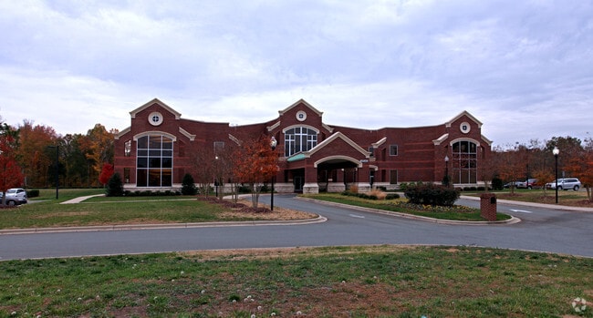
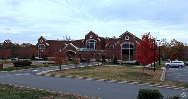
Property Record
14542 Choate Cir, Charlotte, NC 28273

NEARBY LISTINGS FOR SALE OR LEASE
-
-
View all Charlotte listings for sale on LoopNet.com
Property Detail
14542 Choate Cir
219-311-98
Mecklenburg
Commercialnec
North Carolina
AE
98
3710441900K
19.27 AC
2022
Airport
2025
Charlotte
005931
Charlotte-Concord-Gastonia, NC-SC
56,465 SF
DEMOGRAPHICS near 14542 Choate Cir
1 Mile
3 Mile
5 Mile
2024 Total Population
5,159
53,035
139,395
2029 Population
5,484
57,725
151,977
Pop Growth 2024-2029
+ 6.30%
+ 8.84%
+ 9.03%
Average Age
38
38
38
2024 Total Households
2,073
20,597
53,835
HH Growth 2024-2029
+ 6.22%
+ 8.92%
+ 9.05%
Median Household Inc
$85,124
$85,992
$89,075
Avg Household Size
2.50
2.50
2.50
2024 Avg HH Vehicles
2.00
2.00
2.00
Median Home Value
$283,121
$317,968
$340,760
Median Year Built
1998
2004
2006
Nearby Places
Map Layers
Map Styles
 Street
 Aerial
- Restaurants
- Banks
- Shops
- Fitness
- Groceries
PUBLIC TRANSPORTATION
AIRPORT
Charlotte/Douglas International
DRIVE
WALK
Distance
Charlotte/Douglas International
21 min
10.0 mi
Concord-Padgett Regional
DRIVE
WALK
Distance
Concord-Padgett Regional
43 min
33.0 mi
Freight Ports
North Charleston Terminal
DRIVE
WALK
Distance
North Charleston Terminal
215 min
190.1 mi
Nearby Properties
Address
Land Use
TOTAL SIZE
Lot Size
Zoning
Address
Land Use
TOTAL SIZE
Lot Size
Zoning
432,123 SF
36.75 AC
R17MFCD
Address
Land Use
TOTAL SIZE
Lot Size
Zoning
1,007,888 SF
55.04 AC
G-I
Address
Land Use
TOTAL SIZE
Lot Size
Zoning
283,424 SF
24.95 AC
R17MFCD
Address
Land Use
TOTAL SIZE
Lot Size
Zoning
369,622 SF
26.29 AC
R17MFCD
Address
Land Use
TOTAL SIZE
Lot Size
Zoning
252,275 SF
20.23 AC
Address
Land Use
TOTAL SIZE
Lot Size
Zoning
280,293 SF
25.47 AC
R3
Address
Land Use
TOTAL SIZE
Lot Size
Zoning
250,307 SF
15.53 AC
R17MFCD
Address
Land Use
TOTAL SIZE
Lot Size
Zoning
1,396,936 SF
68.78 AC
I2
Address
Land Use
TOTAL SIZE
Lot Size
Zoning
899,731 SF
73.49 AC
Address
Land Use
TOTAL SIZE
Lot Size
Zoning
857,532 SF
73.57 AC
I1
Address
Land Use
TOTAL SIZE
Lot Size
Zoning
218,322 SF
15.93 AC
R17MFCD
Address
Land Use
TOTAL SIZE
Lot Size
Zoning
269,639 SF
15.32 AC
R17MFCD
Address
Land Use
TOTAL SIZE
Lot Size
Zoning
275,215 SF
12.35 AC
R17MFCD
Address
Land Use
TOTAL SIZE
Lot Size
Zoning
245,573 SF
23.62 AC
R12MFCD
Address
Land Use
TOTAL SIZE
Lot Size
Zoning
213,739 SF
9.79 AC
MUDDO
Address
Land Use
TOTAL SIZE
Lot Size
Zoning
220,232 SF
15.45 AC
R15MFCD
Address
Land Use
TOTAL SIZE
Lot Size
Zoning
873,356 SF
52.31 AC
I2
Address
Land Use
TOTAL SIZE
Lot Size
Zoning
151,844 SF
11.65 AC
Address
Land Use
TOTAL SIZE
Lot Size
Zoning
182,235 SF
18.29 AC
R17MF
Address
Land Use
TOTAL SIZE
Lot Size
Zoning
124,458 SF
17.15 AC
CC
Address
Land Use
TOTAL SIZE
Lot Size
Zoning
559,210 SF
45.69 AC
I1
Address
Land Use
TOTAL SIZE
Lot Size
Zoning
169,440 SF
8.08 AC
MUDDO
Address
Land Use
TOTAL SIZE
Lot Size
Zoning
363,238 SF
153.46 AC
Address
Land Use
TOTAL SIZE
Lot Size
Zoning
Address
Land Use
TOTAL SIZE
Lot Size
Zoning
403,200 SF
56.47 AC
Address
Land Use
TOTAL SIZE
Lot Size
Zoning
596,863 SF
41.28 AC
I-2
Address
Land Use
TOTAL SIZE
Lot Size
Zoning
145,486 SF
16.78 AC
R17MFCD
Address
Land Use
TOTAL SIZE
Lot Size
Zoning
271,500 SF
31.78 AC
I-2
Address
Land Use
TOTAL SIZE
Lot Size
Zoning
113,825 SF
10.54 AC
CC
Address
Land Use
TOTAL SIZE
Lot Size
Zoning
36.84 AC
UD
The World's #1 Commercial Real Estate Marketplace
Connect with us
© 2025 CoStar Group
The information above has been obtained from sources believed reliable. While we do not doubt its accuracy we have not verified it and make no guarantee, warranty or representation about it. It is your responsibility to independently confirm its accuracy and completeness. Any projections, opinions, assumptions, or estimates used are for example only and do not represent the current or future performance of the property. The value of this transaction to you depends on tax and other factors which should be evaluated by your tax, financial, and legal advisors. You and your advisors should conduct a careful, independent investigation of the property to determine to your satisfaction the suitability of the property for your needs.