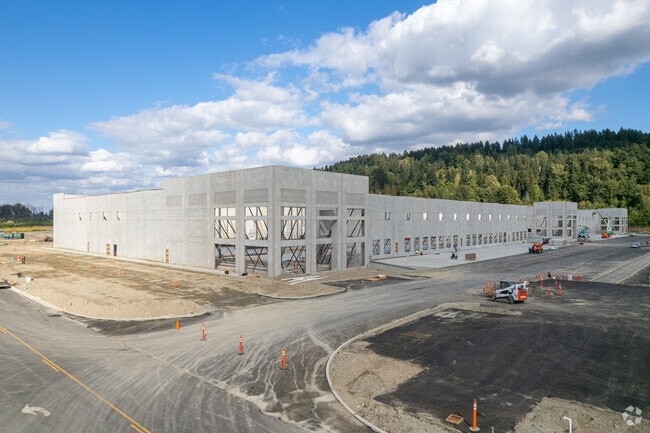
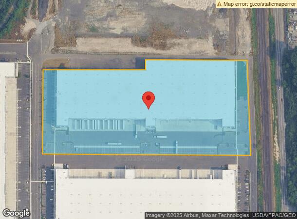
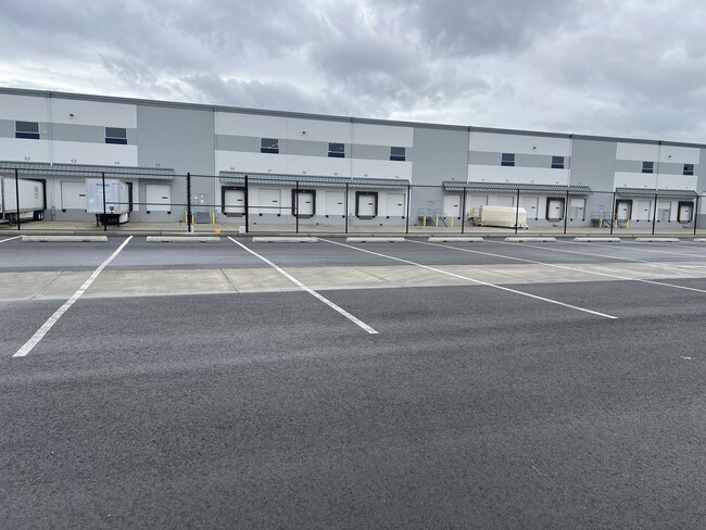
Property Record
14545 Stewart Rd, Sumner, WA 98390
NEARBY LISTINGS FOR SALE OR LEASE
Property Detail
14545 Stewart Rd
042001-1053
SECTION 01 TOWNSHIP 20 RANGE 04 QUARTER 11 : PARCEL 2 OF ROS FOR BLA 2024-10-09-5003 DESC AS FOLL REVISED L 7 BLA 2022-05-24-5004 TOG/W S 5 FT OF REVISED L 6 SD BLA EASE OF REC OUT OF 04-20-01-1-041, 1-042, 1-043 & 1-046 SEG 2023-0001 06/08/22 JP 391
Warehouse
Pierce
AE
Washington
53033C1263G
7
2024
12.76 AC
2025
Puyallup/S Hill
073301
Seattle/Puget Sound
292,072 SF
Seattle-Tacoma-Bellevue, WA
DEMOGRAPHICS near 14545 Stewart Rd
1 Mile
3 Mile
5 Mile
2024 Total Population
10,159
58,802
151,318
2029 Population
10,325
59,565
153,666
Pop Growth 2024-2029
+ 1.63%
+ 1.30%
+ 1.55%
Average Age
38
38
39
2024 Total Households
3,747
20,372
55,017
HH Growth 2024-2029
+ 1.65%
+ 1.26%
+ 1.56%
Median Household Inc
$100,428
$95,081
$88,436
Avg Household Size
2.70
2.80
2.70
2024 Avg HH Vehicles
2.00
2.00
2.00
Median Home Value
$432,143
$455,457
$467,130
Median Year Built
2000
1990
1987
Nearby Places
Map Layers
Map Styles
 Street
 Aerial
- Restaurants
- Banks
- Shops
- Fitness
- Groceries
PUBLIC TRANSPORTATION
COMMUTER RAIL
Auburn Station (Seattle - Tacoma/Lakewood - Sound Transit, Sounder South Line - Sound Transit)
DRIVE
WALK
Distance
Auburn Station (Seattle - Tacoma/Lakewood - Sound Transit, Sounder South Line - Sound Transit)
13 min
6.3 mi
Sumner Station (Sounder South Line - Central Puget Sound Regional Transit Authority Rail (Link Light Rail/Sounder))
DRIVE
WALK
Distance
Sumner Station (Sounder South Line - Central Puget Sound Regional Transit Authority Rail (Link Light Rail/Sounder))
13 min
6.6 mi
AIRPORT
Seattle-Tacoma International
DRIVE
WALK
Distance
Seattle-Tacoma International
34 min
18.5 mi
Freight Ports
Port of Tacoma
DRIVE
WALK
Distance
Port of Tacoma
22 min
10.8 mi
SALE & LEASE HISTORY
LISTING DATE
SALE/LEASE

Dec 10, 2020
For Lease
Apr 05, 2024
For Lease
Apr 04, 2024
For Lease
Nearby Properties
Address
Land Use
TOTAL SIZE
Lot Size
Zoning
Address
Land Use
TOTAL SIZE
Lot Size
Zoning
524,636 SF
102.29 AC
M2
Address
Land Use
TOTAL SIZE
Lot Size
Zoning
833,773 SF
94.01 AC
M1
Address
Land Use
TOTAL SIZE
Lot Size
Zoning
749,967 SF
39.82 AC
M2
Address
Land Use
TOTAL SIZE
Lot Size
Zoning
63,950 SF
127.86 AC
C3
Address
Land Use
TOTAL SIZE
Lot Size
Zoning
217,000 SF
19.99 AC
R20
Address
Land Use
TOTAL SIZE
Lot Size
Zoning
648,679 SF
27.43 AC
M1
Address
Land Use
TOTAL SIZE
Lot Size
Zoning
258,297 SF
16.13 AC
BP
Address
Land Use
TOTAL SIZE
Lot Size
Zoning
Address
Land Use
TOTAL SIZE
Lot Size
Zoning
501,104 SF
21.73 AC
Address
Land Use
TOTAL SIZE
Lot Size
Zoning
506,925 SF
24.22 AC
M1
Address
Land Use
TOTAL SIZE
Lot Size
Zoning
521,674 SF
24.55 AC
M1
Address
Land Use
TOTAL SIZE
Lot Size
Zoning
255,871 SF
11.17 AC
EDGWD
Address
Land Use
TOTAL SIZE
Lot Size
Zoning
492,124 SF
21.54 AC
M1
Address
Land Use
TOTAL SIZE
Lot Size
Zoning
441,316 SF
20.26 AC
Address
Land Use
TOTAL SIZE
Lot Size
Zoning
251,498 SF
13.79 AC
LAKELAND H
Address
Land Use
TOTAL SIZE
Lot Size
Zoning
503,526 SF
16.52 AC
M1
Address
Land Use
TOTAL SIZE
Lot Size
Zoning
215,619 SF
21.57 AC
TV
Address
Land Use
TOTAL SIZE
Lot Size
Zoning
287,945 SF
11.12 AC
M-1
Address
Land Use
TOTAL SIZE
Lot Size
Zoning
430,880 SF
23.46 AC
M1
Address
Land Use
TOTAL SIZE
Lot Size
Zoning
428,056 SF
17.45 AC
M1
Address
Land Use
TOTAL SIZE
Lot Size
Zoning
204,727 SF
18.63 AC
TV
Address
Land Use
TOTAL SIZE
Lot Size
Zoning
401,076 SF
16.77 AC
M1
Address
Land Use
TOTAL SIZE
Lot Size
Zoning
385,468 SF
18.22 AC
M1
Address
Land Use
TOTAL SIZE
Lot Size
Zoning
427,253 SF
18.46 AC
M1
Address
Land Use
TOTAL SIZE
Lot Size
Zoning
278,038 SF
12.91 AC
M-1
Address
Land Use
TOTAL SIZE
Lot Size
Zoning
270,739 SF
12.21 AC
M-1
Address
Land Use
TOTAL SIZE
Lot Size
Zoning
382,800 SF
19.15 AC
M1
Address
Land Use
TOTAL SIZE
Lot Size
Zoning
370,087 SF
15.61 AC
M1
The World's #1 Commercial Real Estate Marketplace
Connect with us
© 2025 CoStar Group
The information above has been obtained from sources believed reliable. While we do not doubt its accuracy we have not verified it and make no guarantee, warranty or representation about it. It is your responsibility to independently confirm its accuracy and completeness. Any projections, opinions, assumptions, or estimates used are for example only and do not represent the current or future performance of the property. The value of this transaction to you depends on tax and other factors which should be evaluated by your tax, financial, and legal advisors. You and your advisors should conduct a careful, independent investigation of the property to determine to your satisfaction the suitability of the property for your needs.