Property Record
1455 Moreland Ave Se, Atlanta, GA 30316

NEARBY LISTINGS FOR SALE OR LEASE
Property Detail
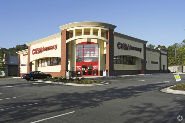
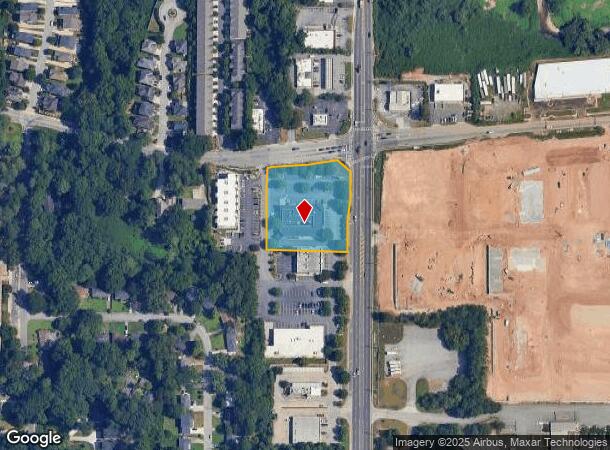
1455 Moreland Ave Se
Atlanta-Sandy Springs-Roswell, GA
Not Shown
14-0009-LL-127-4
CVS PHARMACY AT MORLAND STATION FC 12/23
Storebuilding
Fulton
X
Georgia
13121C0378F
2
2024
1.60 AC
2025
SE Atlanta
006900
Atlanta
13,031 SF
DEMOGRAPHICS near 1455 Moreland Ave Se
1 Mile
3 Mile
5 Mile
2024 Total Population
9,341
99,734
306,927
2029 Population
9,661
103,256
315,846
Pop Growth 2024-2029
+ 3.43%
+ 3.53%
+ 2.91%
Average Age
36
37
37
2024 Total Households
3,561
43,670
132,991
HH Growth 2024-2029
+ 3.54%
+ 3.66%
+ 3.23%
Median Household Inc
$76,953
$67,524
$70,937
Avg Household Size
2.30
2.20
2.10
2024 Avg HH Vehicles
2.00
1.00
1.00
Median Home Value
$349,725
$377,138
$378,460
Median Year Built
1968
1977
1978
Nearby Places
Map Layers
Map Styles
 Street
 Aerial
- Restaurants
- Banks
- Shops
- Fitness
- Groceries
PUBLIC TRANSPORTATION
COMMUTER RAIL
DRIVE
WALK
Distance
16 min
7.9 mi
AIRPORT
Hartsfield - Jackson Atlanta International
DRIVE
WALK
Distance
Hartsfield - Jackson Atlanta International
19 min
10.1 mi
SALE & LEASE HISTORY
LISTING DATE
SALE/LEASE

Nov 21, 2018
For Sale
Nearby Properties
Address
Land Use
TOTAL SIZE
Lot Size
Zoning
Address
Land Use
TOTAL SIZE
Lot Size
Zoning
7 AC
C3
Address
Land Use
TOTAL SIZE
Lot Size
Zoning
543,748 SF
3.86 AC
I2
Address
Land Use
TOTAL SIZE
Lot Size
Zoning
432,056 SF
17.87 AC
C1
Address
Land Use
TOTAL SIZE
Lot Size
Zoning
400,311 SF
4.45 AC
I2
Address
Land Use
TOTAL SIZE
Lot Size
Zoning
498,515 SF
3.41 AC
C1
Address
Land Use
TOTAL SIZE
Lot Size
Zoning
595,658 SF
4.09 AC
I1
Address
Land Use
TOTAL SIZE
Lot Size
Zoning
94.93 AC
R5
Address
Land Use
TOTAL SIZE
Lot Size
Zoning
54 AC
I2
Address
Land Use
TOTAL SIZE
Lot Size
Zoning
290,130 SF
6.13 AC
R100
Address
Land Use
TOTAL SIZE
Lot Size
Zoning
566,872 SF
3.31 AC
I1
Address
Land Use
TOTAL SIZE
Lot Size
Zoning
369,356 SF
2.50 AC
I1
Address
Land Use
TOTAL SIZE
Lot Size
Zoning
469,344 SF
3.62 AC
C3
Address
Land Use
TOTAL SIZE
Lot Size
Zoning
528,810 SF
3.61 AC
I2
Address
Land Use
TOTAL SIZE
Lot Size
Zoning
624,087 SF
4.45 AC
I2
Address
Land Use
TOTAL SIZE
Lot Size
Zoning
436,143 SF
2.90 AC
I1
Address
Land Use
TOTAL SIZE
Lot Size
Zoning
330,125 SF
7.16 AC
I1
Address
Land Use
TOTAL SIZE
Lot Size
Zoning
438,163 SF
4.45 AC
R5
Address
Land Use
TOTAL SIZE
Lot Size
Zoning
283,235 SF
5 AC
RG4
Address
Land Use
TOTAL SIZE
Lot Size
Zoning
363,464 SF
2.92 AC
I2
Address
Land Use
TOTAL SIZE
Lot Size
Zoning
348,894 SF
0.58 AC
I1
Address
Land Use
TOTAL SIZE
Lot Size
Zoning
400,347 SF
3.30 AC
I2
Address
Land Use
TOTAL SIZE
Lot Size
Zoning
335,050 SF
12.90 AC
X
Address
Land Use
TOTAL SIZE
Lot Size
Zoning
444,229 SF
2.76 AC
I1
Address
Land Use
TOTAL SIZE
Lot Size
Zoning
828,718 SF
2.60 AC
I1
Address
Land Use
TOTAL SIZE
Lot Size
Zoning
1,128,762 SF
10.39 AC
I2
Address
Land Use
TOTAL SIZE
Lot Size
Zoning
448,132 SF
0.03 AC
I2
Address
Land Use
TOTAL SIZE
Lot Size
Zoning
317,452 SF
2.58 AC
I2
Address
Land Use
TOTAL SIZE
Lot Size
Zoning
521,674 SF
2.91 AC
I2
Address
Land Use
TOTAL SIZE
Lot Size
Zoning
1,239,747 SF
6.75 AC
I2
Address
Land Use
TOTAL SIZE
Lot Size
Zoning
81,129 SF
4.29 AC
C1
The World's #1 Commercial Real Estate Marketplace
Connect with us
© 2025 CoStar Group
The information above has been obtained from sources believed reliable. While we do not doubt its accuracy we have not verified it and make no guarantee, warranty or representation about it. It is your responsibility to independently confirm its accuracy and completeness. Any projections, opinions, assumptions, or estimates used are for example only and do not represent the current or future performance of the property. The value of this transaction to you depends on tax and other factors which should be evaluated by your tax, financial, and legal advisors. You and your advisors should conduct a careful, independent investigation of the property to determine to your satisfaction the suitability of the property for your needs.