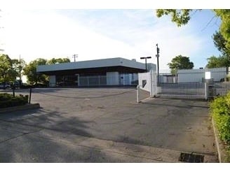
Property Record
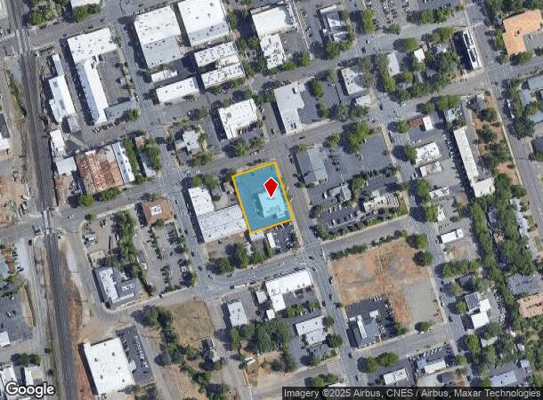
1910 Market St, Redding, CA 96001

NEARBY LISTINGS FOR SALE OR LEASE
Property Detail
1910 Market St
101-750-023-000
Frisbies Addition
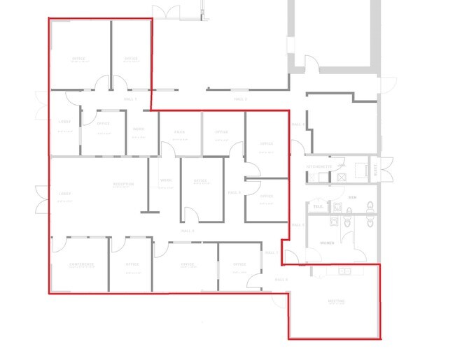
Officebuilding
Shasta
X
California
06089C1539G
4
2024
0.69 AC
2025
Redding/Chico
010100
Other Market Areas
4,832 SF
Redding, CA
DEMOGRAPHICS near 1910 Market St
1 Mile
3 Mile
5 Mile
2024 Total Population
10,059
61,402
101,540
2029 Population
10,145
61,607
101,764
Pop Growth 2024-2029
+ 0.85%
+ 0.33%
+ 0.22%
Average Age
41
41
41
2024 Total Households
4,645
25,749
40,838
HH Growth 2024-2029
+ 1.10%
+ 0.38%
+ 0.26%
Median Household Inc
$39,747
$57,021
$63,021
Avg Household Size
2.00
2.30
2.40
2024 Avg HH Vehicles
1.00
2.00
2.00
Median Home Value
$291,176
$333,626
$347,682
Median Year Built
1967
1980
1982
Nearby Places
- Restaurants
- Banks
- Shops
- Fitness
- Groceries
PUBLIC TRANSPORTATION
COMMUTER RAIL
Redding Amtrak (Coast Starlight - Amtrak)
DRIVE
WALK
Distance
Redding Amtrak (Coast Starlight - Amtrak)
1 min
7 min
0.4 mi
AIRPORT
Redding Regional
DRIVE
WALK
Distance
Redding Regional
13 min
9.4 mi
Freight Ports
Port of Richmond
DRIVE
WALK
Distance
Port of Richmond
231 min
206.0 mi
SALE & LEASE HISTORY
LISTING DATE
SALE/LEASE

Mar 01, 2022
For Lease
Nearby Properties
Address
Land Use
TOTAL SIZE
Lot Size
Zoning
Address
Land Use
TOTAL SIZE
Lot Size
Zoning
15.20 AC
Address
Land Use
TOTAL SIZE
Lot Size
Zoning
2.60 AC
Address
Land Use
TOTAL SIZE
Lot Size
Zoning
6.36 AC
Address
Land Use
TOTAL SIZE
Lot Size
Zoning
71,579 SF
4.37 AC
Address
Land Use
TOTAL SIZE
Lot Size
Zoning
72,875 SF
3.93 AC
Address
Land Use
TOTAL SIZE
Lot Size
Zoning
31,365 SF
1.33 AC
Address
Land Use
TOTAL SIZE
Lot Size
Zoning
8.22 AC
Address
Land Use
TOTAL SIZE
Lot Size
Zoning
223,579 SF
19.65 AC
Address
Land Use
TOTAL SIZE
Lot Size
Zoning
Address
Land Use
TOTAL SIZE
Lot Size
Zoning
89,098 SF
7.24 AC
Address
Land Use
TOTAL SIZE
Lot Size
Zoning
54,720 SF
2.53 AC
Address
Land Use
TOTAL SIZE
Lot Size
Zoning
21,089 SF
7 AC
Address
Land Use
TOTAL SIZE
Lot Size
Zoning
47,062 SF
4.80 AC
Address
Land Use
TOTAL SIZE
Lot Size
Zoning
143,164 SF
13.90 AC
Address
Land Use
TOTAL SIZE
Lot Size
Zoning
108,208 SF
7.96 AC
Address
Land Use
TOTAL SIZE
Lot Size
Zoning
19,572 SF
5.94 AC
Address
Land Use
TOTAL SIZE
Lot Size
Zoning
5.44 AC
Address
Land Use
TOTAL SIZE
Lot Size
Zoning
61,754 SF
1.73 AC
Address
Land Use
TOTAL SIZE
Lot Size
Zoning
92,699 SF
5.91 AC
Address
Land Use
TOTAL SIZE
Lot Size
Zoning
10.27 AC
Address
Land Use
TOTAL SIZE
Lot Size
Zoning
1,500 SF
69.70 AC
Address
Land Use
TOTAL SIZE
Lot Size
Zoning
104,740 SF
23.54 AC
Address
Land Use
TOTAL SIZE
Lot Size
Zoning
95,645 SF
9.55 AC
Address
Land Use
TOTAL SIZE
Lot Size
Zoning
134,868 SF
0.57 AC
Address
Land Use
TOTAL SIZE
Lot Size
Zoning
2.42 AC
Address
Land Use
TOTAL SIZE
Lot Size
Zoning
2,821 SF
136.53 AC
Address
Land Use
TOTAL SIZE
Lot Size
Zoning
101,683 SF
8.48 AC
Address
Land Use
TOTAL SIZE
Lot Size
Zoning
83,276 SF
3.02 AC
Address
Land Use
TOTAL SIZE
Lot Size
Zoning
16,320 SF
3.76 AC
Address
Land Use
TOTAL SIZE
Lot Size
Zoning
55,351 SF
5.65 AC
The World's #1 Commercial Real Estate Marketplace
Connect with us
© 2025 CoStar Group
The information above has been obtained from sources believed reliable. While we do not doubt its accuracy we have not verified it and make no guarantee, warranty or representation about it. It is your responsibility to independently confirm its accuracy and completeness. Any projections, opinions, assumptions, or estimates used are for example only and do not represent the current or future performance of the property. The value of this transaction to you depends on tax and other factors which should be evaluated by your tax, financial, and legal advisors. You and your advisors should conduct a careful, independent investigation of the property to determine to your satisfaction the suitability of the property for your needs.