Property Record
14550 E Highway 24, Peyton, CO 80831
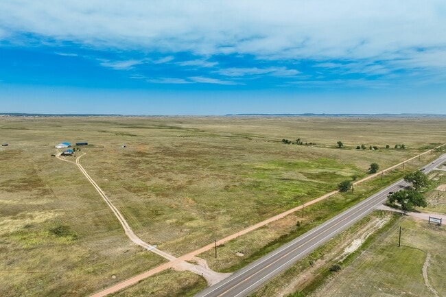

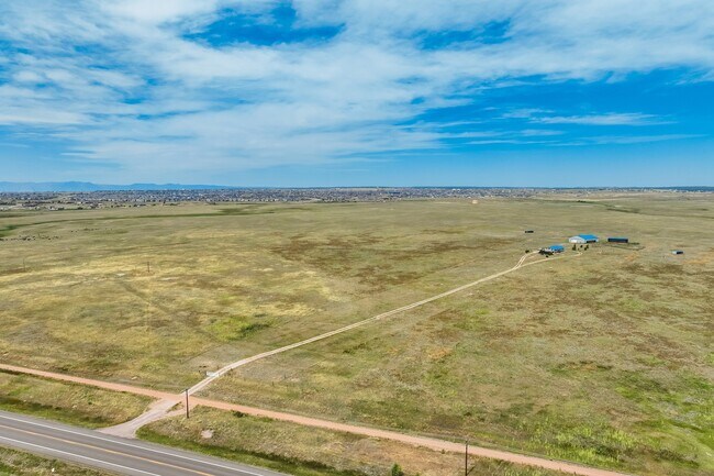
This Property Is For Sale
Property Detail
14550 E Highway 24
42000-00-148
SE4 EX THAT PART LY SELY OF SELY LN OF U S HWY 24, EX RD, EX RY, SEC 28-12-64 THAT PART OF NW4NE4 LY NWLY OF CRI + PRY SEC 33-12-64
Wellsiteagricultural
EL PASO
A-35
Colorado
A Areas with a 1% annual chance of flooding and a 26% chance of flooding over the life of a 30-year mortgage.
116.47 AC
2024
Northeast
2025
Colorado Springs
003914
Colorado Springs, CO
3,376 SF
NEARBY LISTINGS FOR SALE OR LEASE
-
-
View all Peyton listings for sale on LoopNet.com
DEMOGRAPHICS near 14550 E Highway 24
1 mile
3 mile
5 mile
2025 Total Population
272
18,271
30,598
2030 Population
278
18,795
31,408
Pop Growth 2025-2030
+ 2.21%
+ 2.87%
+ 2.65%
Average Age
35
35
37
2025 Total Households
81
5,462
9,708
HH Growth 2025-2030
+ 2.47%
+ 3.08%
+ 2.87%
Median Household Inc
$139,583
$144,724
$139,473
Avg Household Size
3.30
3.30
3.10
2025 Avg HH Vehicles
2.00
2.00
3.00
Median Home Value
$587,500
$627,261
$614,226
Median Year Built
2009
2009
2007
Nearby Places
Map Layers
Map Styles
 Street
 Aerial
Transit
 Traffic
 Biking
Places
Listings with unknown addresses are not visible on the map
- Restaurants
- Banks
- Shops
- Fitness
- Groceries
PUBLIC TRANSPORTATION
AIRPORT
City of Colorado Springs Municipal
Drive
Walk
Distance
City of Colorado Springs Municipal
27 min
14.6 mi
Freight Ports
Tulsa Port Of Catoosa
Drive
Walk
Distance
Tulsa Port Of Catoosa
711 min
675.3 mi
Nearby Properties
Address
Land Use
TOTAL SIZE
Lot Size
Zoning
Address
Land Use
TOTAL SIZE
Lot Size
Zoning
43,256 SF
4.49 AC
PUD
Address
Land Use
TOTAL SIZE
Lot Size
Zoning
43,256 SF
4.73 AC
Address
Land Use
TOTAL SIZE
Lot Size
Zoning
39,446 SF
10.71 AC
RR-5
Address
Land Use
TOTAL SIZE
Lot Size
Zoning
46,935 SF
13.62 AC
PUD
Address
Land Use
TOTAL SIZE
Lot Size
Zoning
16,915 SF
5.19 AC
PUD
Address
Land Use
TOTAL SIZE
Lot Size
Zoning
7,573 SF
757.70 AC
PUD R-4 R-
Address
Land Use
TOTAL SIZE
Lot Size
Zoning
16,455 SF
6.89 AC
A-35 RR-2.
Address
Land Use
TOTAL SIZE
Lot Size
Zoning
219.19 AC
PUD
Address
Land Use
TOTAL SIZE
Lot Size
Zoning
12,111 SF
2.54 AC
PUD
Address
Land Use
TOTAL SIZE
Lot Size
Zoning
29,113 SF
3.43 AC
CR
Address
Land Use
TOTAL SIZE
Lot Size
Zoning
326.51 AC
RR2
Address
Land Use
TOTAL SIZE
Lot Size
Zoning
160 AC
RR-5
Address
Land Use
TOTAL SIZE
Lot Size
Zoning
1.46 AC
CR
Address
Land Use
TOTAL SIZE
Lot Size
Zoning
29,494 SF
4.11 AC
CR
Address
Land Use
TOTAL SIZE
Lot Size
Zoning
54,150 SF
35.33 AC
CS
Address
Land Use
TOTAL SIZE
Lot Size
Zoning
5,561 SF
280 AC
RR5
Address
Land Use
TOTAL SIZE
Lot Size
Zoning
5,341 SF
69.25 AC
A35
Address
Land Use
TOTAL SIZE
Lot Size
Zoning
39.40 AC
PUD
Address
Land Use
TOTAL SIZE
Lot Size
Zoning
1,875 SF
3.91 AC
PUD
Address
Land Use
TOTAL SIZE
Lot Size
Zoning
106.60 AC
RR2
Address
Land Use
TOTAL SIZE
Lot Size
Zoning
31.29 AC
RR-5
Address
Land Use
TOTAL SIZE
Lot Size
Zoning
49.68 AC
M
Address
Land Use
TOTAL SIZE
Lot Size
Zoning
70 AC
PUD
Address
Land Use
TOTAL SIZE
Lot Size
Zoning
6,383 SF
37.73 AC
A35
Address
Land Use
TOTAL SIZE
Lot Size
Zoning
3,332 SF
3.26 AC
PUD
Address
Land Use
TOTAL SIZE
Lot Size
Zoning
2,340 SF
27.11 AC
PUD
Address
Land Use
TOTAL SIZE
Lot Size
Zoning
134.17 AC
A-35 CR M
Address
Land Use
TOTAL SIZE
Lot Size
Zoning
24,440 SF
2.25 AC
R-4 GA-O
Address
Land Use
TOTAL SIZE
Lot Size
Zoning
2,340 SF
3.33 AC
PUD
Address
Land Use
TOTAL SIZE
Lot Size
Zoning
1.46 AC
The World's #1 Commercial Real Estate Marketplace
Connect with us
© 2026 CoStar Group
The information above has been obtained from sources believed reliable. While we do not doubt its accuracy we have not verified it and make no guarantee, warranty or representation about it. It is your responsibility to independently confirm its accuracy and completeness. Any projections, opinions, assumptions, or estimates used are for example only and do not represent the current or future performance of the property. The value of this transaction to you depends on tax and other factors which should be evaluated by your tax, financial, and legal advisors. You and your advisors should conduct a careful, independent investigation of the property to determine to your satisfaction the suitability of the property for your needs.