Property Record
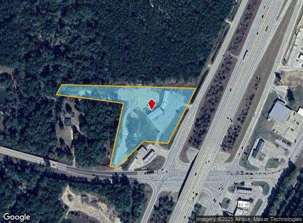
14550 Highway 59 Dr, Splendora, TX 77372

NEARBY LISTINGS FOR SALE OR LEASE
Property Detail
14550 Highway 59 Dr
0082-02-07210
Barker Wm
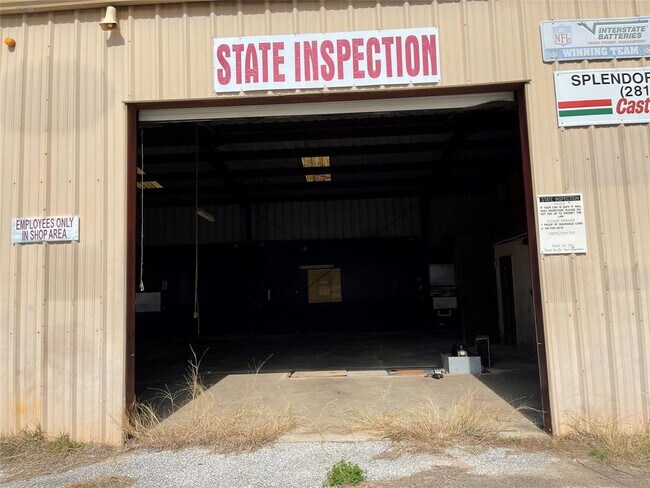
Commercialnec
A0082 - BARKER WM, TRACT 72-A, ACRES 4.8531
AE
Montgomery
48339C0600G
Texas
2024
4.85 AC
2025
Montgomery County
692803
Houston
7,490 SF
Houston-Pasadena-The Woodlands, TX
DEMOGRAPHICS near 14550 Highway 59 Dr
1 Mile
3 Mile
5 Mile
2024 Total Population
1,810
12,930
35,405
2029 Population
2,260
16,088
44,575
Pop Growth 2024-2029
+ 24.86%
+ 24.42%
+ 25.90%
Average Age
37
37
37
2024 Total Households
602
4,211
11,416
HH Growth 2024-2029
+ 25.08%
+ 24.51%
+ 25.79%
Median Household Inc
$81,316
$66,748
$70,733
Avg Household Size
3.00
3.00
3.00
2024 Avg HH Vehicles
2.00
2.00
2.00
Median Home Value
$229,285
$209,144
$223,092
Median Year Built
2000
1998
1999
Nearby Places
Map Layers
Map Styles
 Street
 Aerial
- Restaurants
- Banks
- Shops
- Fitness
- Groceries
PUBLIC TRANSPORTATION
AIRPORT
George Bush Intcntl/Houston
DRIVE
WALK
Distance
George Bush Intcntl/Houston
31 min
25.6 mi
Freight Ports
Port of Houston
DRIVE
WALK
Distance
Port of Houston
53 min
40.9 mi
SALE & LEASE HISTORY
LISTING DATE
SALE/LEASE

Sep 24, 2016
For Sale
Oct 01, 2018
For Sale
Jun 23, 2022
For Sale
Jun 21, 2017
For Sale
Aug 28, 2017
For Sale
Nearby Properties
Address
Land Use
TOTAL SIZE
Lot Size
Zoning
Address
Land Use
TOTAL SIZE
Lot Size
Zoning
154,508 SF
110.45 AC
Address
Land Use
TOTAL SIZE
Lot Size
Zoning
119,211 SF
23.86 AC
Address
Land Use
TOTAL SIZE
Lot Size
Zoning
132,680 SF
5 AC
5
Address
Land Use
TOTAL SIZE
Lot Size
Zoning
84,249 SF
38.34 AC
Address
Land Use
TOTAL SIZE
Lot Size
Zoning
97,193 SF
24.79 AC
5
Address
Land Use
TOTAL SIZE
Lot Size
Zoning
78,721 SF
22.26 AC
Address
Land Use
TOTAL SIZE
Lot Size
Zoning
26,348 SF
30.22 AC
5
Address
Land Use
TOTAL SIZE
Lot Size
Zoning
84,704 SF
4.47 AC
5
Address
Land Use
TOTAL SIZE
Lot Size
Zoning
30,916 SF
3.36 AC
Address
Land Use
TOTAL SIZE
Lot Size
Zoning
3,880 SF
13.32 AC
5
Address
Land Use
TOTAL SIZE
Lot Size
Zoning
19,684 SF
7.90 AC
5
Address
Land Use
TOTAL SIZE
Lot Size
Zoning
12,634 SF
4.74 AC
Address
Land Use
TOTAL SIZE
Lot Size
Zoning
44,160 SF
10.98 AC
5
Address
Land Use
TOTAL SIZE
Lot Size
Zoning
58,972 SF
4.70 AC
5
Address
Land Use
TOTAL SIZE
Lot Size
Zoning
10,792 SF
2.70 AC
Address
Land Use
TOTAL SIZE
Lot Size
Zoning
237 SF
10.51 AC
5
Address
Land Use
TOTAL SIZE
Lot Size
Zoning
19,587 SF
3.50 AC
Address
Land Use
TOTAL SIZE
Lot Size
Zoning
10,640 SF
1.13 AC
Address
Land Use
TOTAL SIZE
Lot Size
Zoning
7,000 SF
4.51 AC
Address
Land Use
TOTAL SIZE
Lot Size
Zoning
36,490 SF
2.72 AC
5
Address
Land Use
TOTAL SIZE
Lot Size
Zoning
9,100 SF
1.71 AC
5
Address
Land Use
TOTAL SIZE
Lot Size
Zoning
23,990 SF
15 AC
5
Address
Land Use
TOTAL SIZE
Lot Size
Zoning
9,740 SF
8.08 AC
5
Address
Land Use
TOTAL SIZE
Lot Size
Zoning
5,279 SF
11.33 AC
5
Address
Land Use
TOTAL SIZE
Lot Size
Zoning
6,193 SF
4.84 AC
5
Address
Land Use
TOTAL SIZE
Lot Size
Zoning
25,300 SF
5.13 AC
The World's #1 Commercial Real Estate Marketplace
Connect with us
© 2026 CoStar Group
The information above has been obtained from sources believed reliable. While we do not doubt its accuracy we have not verified it and make no guarantee, warranty or representation about it. It is your responsibility to independently confirm its accuracy and completeness. Any projections, opinions, assumptions, or estimates used are for example only and do not represent the current or future performance of the property. The value of this transaction to you depends on tax and other factors which should be evaluated by your tax, financial, and legal advisors. You and your advisors should conduct a careful, independent investigation of the property to determine to your satisfaction the suitability of the property for your needs.