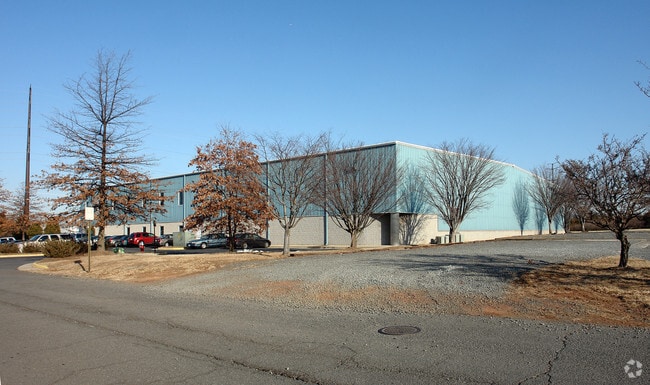
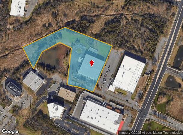
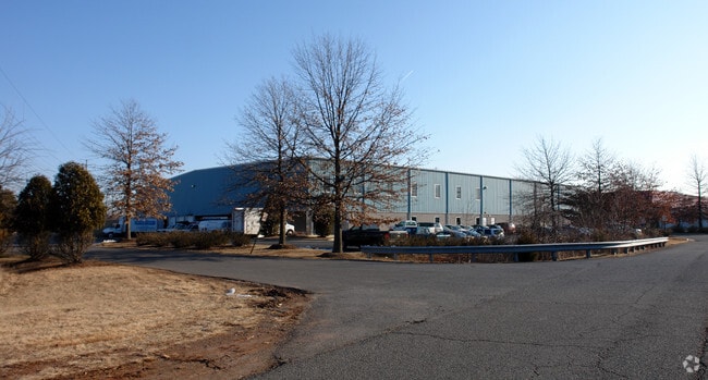
Property Record
14552 Lee Rd, Chantilly, VA 20151
NEARBY LISTINGS FOR SALE OR LEASE
Property Detail
14552 Lee Rd
Washington-Arlington-Alexandria, DC-VA-MD-WV
Southgate Industrial Park
0343-10-0013A
SOUTHGATE INDUSTRIAL PARK LT 13A
Wholesaleoutletdiscountstore
Fairfax
AE
Virginia
51107C0390E
13a
2024
5.94 AC
2025
Rt 28/Dulles South
490104
Washington, DC
45,000 SF
DEMOGRAPHICS near 14552 Lee Rd
1 Mile
3 Mile
5 Mile
2024 Total Population
1,880
60,040
209,091
2029 Population
1,851
59,925
208,656
Pop Growth 2024-2029
(1.54%)
(0.19%)
(0.21%)
Average Age
33
38
38
2024 Total Households
521
19,271
71,416
HH Growth 2024-2029
(1.34%)
(0.39%)
(0.41%)
Median Household Inc
$69,249
$155,085
$144,112
Avg Household Size
3.30
3.00
2.90
2024 Avg HH Vehicles
2.00
2.00
2.00
Median Home Value
$66,732
$645,709
$650,362
Median Year Built
2000
1988
1992
Nearby Places
Map Layers
Map Styles
 Street
 Aerial
- Restaurants
- Banks
- Shops
- Fitness
- Groceries
PUBLIC TRANSPORTATION
AIRPORT
Washington Dulles International
DRIVE
WALK
Distance
Washington Dulles International
18 min
8.8 mi
Ronald Reagan Washington Ntl
DRIVE
WALK
Distance
Ronald Reagan Washington Ntl
44 min
29.4 mi
Freight Ports
Port of Baltimore
DRIVE
WALK
Distance
Port of Baltimore
86 min
65.1 mi
Nearby Properties
Address
Land Use
TOTAL SIZE
Lot Size
Zoning
Address
Land Use
TOTAL SIZE
Lot Size
Zoning
760,000 SF
2,461.49 AC
110
Address
Land Use
TOTAL SIZE
Lot Size
Zoning
1,030,157 SF
47.95 AC
550
Address
Land Use
TOTAL SIZE
Lot Size
Zoning
778,426 SF
48.02 AC
CLI
Address
Land Use
TOTAL SIZE
Lot Size
Zoning
440,870 SF
47.69 AC
550
Address
Land Use
TOTAL SIZE
Lot Size
Zoning
274,000 SF
82.17 AC
PDGI
Address
Land Use
TOTAL SIZE
Lot Size
Zoning
3,419,876 SF
64.12 AC
530
Address
Land Use
TOTAL SIZE
Lot Size
Zoning
1,049,614 SF
67.73 AC
596
Address
Land Use
TOTAL SIZE
Lot Size
Zoning
602,129 SF
32.09 AC
220
Address
Land Use
TOTAL SIZE
Lot Size
Zoning
520,500 SF
7.29 AC
400
Address
Land Use
TOTAL SIZE
Lot Size
Zoning
451,000 SF
7.50 AC
550
Address
Land Use
TOTAL SIZE
Lot Size
Zoning
507,264 SF
10.44 AC
400
Address
Land Use
TOTAL SIZE
Lot Size
Zoning
507,280 SF
50.06 AC
530
Address
Land Use
TOTAL SIZE
Lot Size
Zoning
423,718 SF
26.11 AC
596
Address
Land Use
TOTAL SIZE
Lot Size
Zoning
513,947 SF
22.23 AC
400
Address
Land Use
TOTAL SIZE
Lot Size
Zoning
387,620 SF
6.01 AC
350
Address
Land Use
TOTAL SIZE
Lot Size
Zoning
398,828 SF
3.77 AC
350
Address
Land Use
TOTAL SIZE
Lot Size
Zoning
382,440 SF
3.85 AC
350
Address
Land Use
TOTAL SIZE
Lot Size
Zoning
508,026 SF
43.41 AC
PDGI
Address
Land Use
TOTAL SIZE
Lot Size
Zoning
348,187 SF
40.06 AC
530
Address
Land Use
TOTAL SIZE
Lot Size
Zoning
453,939 SF
17.70 AC
320
Address
Land Use
TOTAL SIZE
Lot Size
Zoning
315,098 SF
15.09 AC
596
Address
Land Use
TOTAL SIZE
Lot Size
Zoning
263,312 SF
10.89 AC
303
Address
Land Use
TOTAL SIZE
Lot Size
Zoning
248,146 SF
12.44 AC
540
Address
Land Use
TOTAL SIZE
Lot Size
Zoning
265,828 SF
17.81 AC
530
Address
Land Use
TOTAL SIZE
Lot Size
Zoning
145,409 SF
11.62 AC
540
Address
Land Use
TOTAL SIZE
Lot Size
Zoning
368,206 SF
22.50 AC
550
Address
Land Use
TOTAL SIZE
Lot Size
Zoning
293,514 SF
10.90 AC
540
Address
Land Use
TOTAL SIZE
Lot Size
Zoning
71,552 SF
127.91 AC
596
Address
Land Use
TOTAL SIZE
Lot Size
Zoning
192,875 SF
20.99 AC
400
Address
Land Use
TOTAL SIZE
Lot Size
Zoning
65,000 SF
109.25 AC
597
The World's #1 Commercial Real Estate Marketplace
Connect with us
© 2025 CoStar Group
The information above has been obtained from sources believed reliable. While we do not doubt its accuracy we have not verified it and make no guarantee, warranty or representation about it. It is your responsibility to independently confirm its accuracy and completeness. Any projections, opinions, assumptions, or estimates used are for example only and do not represent the current or future performance of the property. The value of this transaction to you depends on tax and other factors which should be evaluated by your tax, financial, and legal advisors. You and your advisors should conduct a careful, independent investigation of the property to determine to your satisfaction the suitability of the property for your needs.