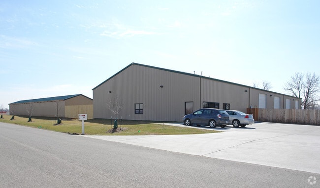
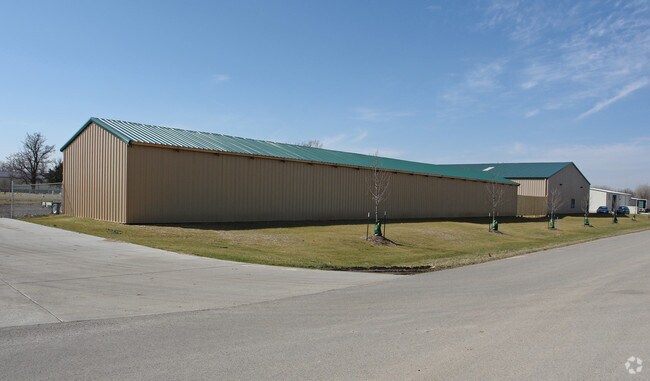
Property Record
1457 N 1823 Rd, Lawrence, KS 66044


NEARBY LISTINGS FOR SALE OR LEASE
Property Detail
1457 N 1823 Rd
Lawrence, KS
Subdivision 1079
023-074-18-0-00-00-012.04-0
MAPLE GROVE NORTH NO 3 REPLAT OF LOTS 1 AND 2 MAPLE GROVE NORTH AND LOT 1 MAPLE GROVE NORTH NO 2 LT 4 DCK
Warehouse
Douglas
X
Kansas
20045C0088E
1-2,4
2025
3.10 AC
2025
Lawrence
000100
Kansas City
11,250 SF
DEMOGRAPHICS near 1457 N 1823 Rd
1 Mile
3 Mile
5 Mile
2024 Total Population
112
23,928
75,755
2029 Population
120
24,452
77,301
Pop Growth 2024-2029
+ 7.14%
+ 2.19%
+ 2.04%
Average Age
41
35
35
2024 Total Households
43
10,291
31,589
HH Growth 2024-2029
+ 6.98%
+ 2.36%
+ 2.25%
Median Household Inc
$65,357
$52,386
$53,670
Avg Household Size
2.40
2.10
2.10
2024 Avg HH Vehicles
2.00
2.00
2.00
Median Home Value
$244,117
$229,199
$223,111
Median Year Built
2001
1977
1981
Nearby Places
Map Layers
Map Styles
 Street
 Aerial
- Restaurants
- Banks
- Shops
- Fitness
- Groceries
PUBLIC TRANSPORTATION
COMMUTER RAIL
Lawrence Amtrak Station (Southwest Chief - Amtrak)
DRIVE
WALK
Distance
Lawrence Amtrak Station (Southwest Chief - Amtrak)
5 min
2.7 mi
Freight Ports
Tulsa Port Of Catoosa
DRIVE
WALK
Distance
Tulsa Port Of Catoosa
261 min
216.2 mi
Nearby Properties
Address
Land Use
TOTAL SIZE
Lot Size
Zoning
Address
Land Use
TOTAL SIZE
Lot Size
Zoning
63,837 SF
20.79 AC
H
Address
Land Use
TOTAL SIZE
Lot Size
Zoning
112,500 SF
3.90 AC
RM1
Address
Land Use
TOTAL SIZE
Lot Size
Zoning
47,457 SF
2.58 AC
Address
Land Use
TOTAL SIZE
Lot Size
Zoning
162,086 SF
3 AC
RD
Address
Land Use
TOTAL SIZE
Lot Size
Zoning
67,500 SF
4.03 AC
RM1
Address
Land Use
TOTAL SIZE
Lot Size
Zoning
5,984 SF
142.30 AC
M2
Address
Land Use
TOTAL SIZE
Lot Size
Zoning
31,750 SF
0.73 AC
Address
Land Use
TOTAL SIZE
Lot Size
Zoning
34,479 SF
1.08 AC
C4
Address
Land Use
TOTAL SIZE
Lot Size
Zoning
131,625 SF
2.32 AC
C3
Address
Land Use
TOTAL SIZE
Lot Size
Zoning
2,728 SF
305 AC
RS1
Address
Land Use
TOTAL SIZE
Lot Size
Zoning
24,600 SF
8.90 AC
M3
Address
Land Use
TOTAL SIZE
Lot Size
Zoning
53,064 SF
5.79 AC
M2
Address
Land Use
TOTAL SIZE
Lot Size
Zoning
53,678 SF
9.40 AC
RS2
Address
Land Use
TOTAL SIZE
Lot Size
Zoning
54,719 SF
5.30 AC
RS2
Address
Land Use
TOTAL SIZE
Lot Size
Zoning
47,152 SF
4.16 AC
RS2
Address
Land Use
TOTAL SIZE
Lot Size
Zoning
5,506 SF
6.10 AC
Address
Land Use
TOTAL SIZE
Lot Size
Zoning
35,209 SF
4.56 AC
O1
Address
Land Use
TOTAL SIZE
Lot Size
Zoning
21,856 SF
0.86 AC
RO1
Address
Land Use
TOTAL SIZE
Lot Size
Zoning
467,472 SF
5.06 AC
RD
Address
Land Use
TOTAL SIZE
Lot Size
Zoning
38,914 SF
0.67 AC
C3
Address
Land Use
TOTAL SIZE
Lot Size
Zoning
48,077 SF
8.70 AC
RS2
Address
Land Use
TOTAL SIZE
Lot Size
Zoning
32,964 SF
3.31 AC
RS2
Address
Land Use
TOTAL SIZE
Lot Size
Zoning
25,503 SF
4.50 AC
C4
Address
Land Use
TOTAL SIZE
Lot Size
Zoning
16,013 SF
Address
Land Use
TOTAL SIZE
Lot Size
Zoning
25,779 SF
1.15 AC
RM3
Address
Land Use
TOTAL SIZE
Lot Size
Zoning
29,554 SF
1.07 AC
RO1
Address
Land Use
TOTAL SIZE
Lot Size
Zoning
62,756 SF
7.20 AC
M2
Address
Land Use
TOTAL SIZE
Lot Size
Zoning
944,874 SF
49.40 AC
M2
Address
Land Use
TOTAL SIZE
Lot Size
Zoning
20,256 SF
0.54 AC
C3
Address
Land Use
TOTAL SIZE
Lot Size
Zoning
51,058 SF
4.50 AC
RS2
The World's #1 Commercial Real Estate Marketplace
Connect with us
© 2025 CoStar Group
The information above has been obtained from sources believed reliable. While we do not doubt its accuracy we have not verified it and make no guarantee, warranty or representation about it. It is your responsibility to independently confirm its accuracy and completeness. Any projections, opinions, assumptions, or estimates used are for example only and do not represent the current or future performance of the property. The value of this transaction to you depends on tax and other factors which should be evaluated by your tax, financial, and legal advisors. You and your advisors should conduct a careful, independent investigation of the property to determine to your satisfaction the suitability of the property for your needs.