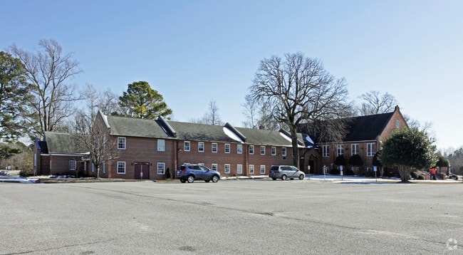
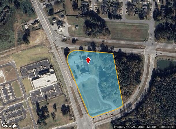
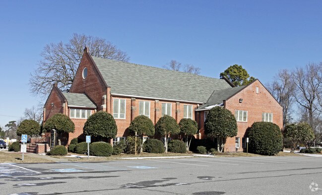
Property Record
14571 Benns Church Blvd, Smithfield, VA 23430
NEARBY LISTINGS FOR SALE OR LEASE
-
-
View all Smithfield listings for sale on LoopNet.com
Property Detail
14571 Benns Church Blvd
32-01-084
PLAT #170004220
Religious
Isle of Wight
X
Virginia
51093C0165E
7.03 AC
2025
Isle Of Wight
2025
Hampton Roads
280107
Virginia Beach-Chesapeake-Norfolk, VA-NC
16,248 SF
DEMOGRAPHICS near 14571 Benns Church Blvd
1 Mile
3 Mile
5 Mile
2024 Total Population
2,031
10,106
26,014
2029 Population
2,272
11,037
28,441
Pop Growth 2024-2029
+ 11.87%
+ 9.21%
+ 9.33%
Average Age
42
42
42
2024 Total Households
755
3,911
10,163
HH Growth 2024-2029
+ 11.79%
+ 9.03%
+ 9.23%
Median Household Inc
$100,140
$104,344
$99,630
Avg Household Size
2.70
2.60
2.50
2024 Avg HH Vehicles
3.00
2.00
2.00
Median Home Value
$364,240
$350,403
$357,874
Median Year Built
1998
1996
1993
Nearby Places
Map Layers
Map Styles
 Street
 Aerial
- Restaurants
- Banks
- Shops
- Fitness
- Groceries
PUBLIC TRANSPORTATION
AIRPORT
Newport News/Williamsburg International
DRIVE
WALK
Distance
Newport News/Williamsburg International
34 min
19.8 mi
Norfolk International
DRIVE
WALK
Distance
Norfolk International
46 min
27.6 mi
Freight Ports
Virginia Port Authority - Newport News
DRIVE
WALK
Distance
Virginia Port Authority - Newport News
22 min
13.1 mi
Nearby Properties
Address
Land Use
TOTAL SIZE
Lot Size
Zoning
Address
Land Use
TOTAL SIZE
Lot Size
Zoning
79.87 AC
RAC
Address
Land Use
TOTAL SIZE
Lot Size
Zoning
27,718 SF
18.75 AC
Address
Land Use
TOTAL SIZE
Lot Size
Zoning
3,998 SF
15.79 AC
01
Address
Land Use
TOTAL SIZE
Lot Size
Zoning
51,086 SF
43.12 AC
01
Address
Land Use
TOTAL SIZE
Lot Size
Zoning
99,606 SF
34.89 AC
RAC
Address
Land Use
TOTAL SIZE
Lot Size
Zoning
52,944 SF
9.67 AC
TOWN
Address
Land Use
TOTAL SIZE
Lot Size
Zoning
35.19 AC
01
Address
Land Use
TOTAL SIZE
Lot Size
Zoning
26,471 SF
29.55 AC
01
Address
Land Use
TOTAL SIZE
Lot Size
Zoning
57,513 SF
11.37 AC
Address
Land Use
TOTAL SIZE
Lot Size
Zoning
58,368 SF
2.51 AC
TOWN
Address
Land Use
TOTAL SIZE
Lot Size
Zoning
22,750 SF
19.51 AC
RAC
Address
Land Use
TOTAL SIZE
Lot Size
Zoning
99.89 AC
01
Address
Land Use
TOTAL SIZE
Lot Size
Zoning
13,512 SF
8.07 AC
TOWN
Address
Land Use
TOTAL SIZE
Lot Size
Zoning
15,600 SF
5.09 AC
TOWN
Address
Land Use
TOTAL SIZE
Lot Size
Zoning
4,900 SF
1.17 AC
Address
Land Use
TOTAL SIZE
Lot Size
Zoning
3,236 SF
55.59 AC
01
Address
Land Use
TOTAL SIZE
Lot Size
Zoning
45,170 SF
3.05 AC
TOWN
Address
Land Use
TOTAL SIZE
Lot Size
Zoning
19,120 SF
3.65 AC
TOWN
Address
Land Use
TOTAL SIZE
Lot Size
Zoning
7,127 SF
22.64 AC
TOWN
Address
Land Use
TOTAL SIZE
Lot Size
Zoning
13,460 SF
3.47 AC
TOWN
Address
Land Use
TOTAL SIZE
Lot Size
Zoning
14,790 SF
3.28 AC
TOWN
Address
Land Use
TOTAL SIZE
Lot Size
Zoning
4,744 SF
5.11 AC
Address
Land Use
TOTAL SIZE
Lot Size
Zoning
110 AC
RAC
Address
Land Use
TOTAL SIZE
Lot Size
Zoning
183.37 AC
RAC
Address
Land Use
TOTAL SIZE
Lot Size
Zoning
16,963 SF
2.36 AC
TOWN
Address
Land Use
TOTAL SIZE
Lot Size
Zoning
13,512 SF
9.75 AC
TOWN
Address
Land Use
TOTAL SIZE
Lot Size
Zoning
12,114 SF
3.05 AC
TOWN
Address
Land Use
TOTAL SIZE
Lot Size
Zoning
44,160 SF
2.83 AC
TOWN
Address
Land Use
TOTAL SIZE
Lot Size
Zoning
11,114 SF
2.42 AC
TOWN
Address
Land Use
TOTAL SIZE
Lot Size
Zoning
17,500 SF
2.58 AC
TOWN
The World's #1 Commercial Real Estate Marketplace
Connect with us
© 2026 CoStar Group
The information above has been obtained from sources believed reliable. While we do not doubt its accuracy we have not verified it and make no guarantee, warranty or representation about it. It is your responsibility to independently confirm its accuracy and completeness. Any projections, opinions, assumptions, or estimates used are for example only and do not represent the current or future performance of the property. The value of this transaction to you depends on tax and other factors which should be evaluated by your tax, financial, and legal advisors. You and your advisors should conduct a careful, independent investigation of the property to determine to your satisfaction the suitability of the property for your needs.