Property Record
David St, Adel, GA 31620
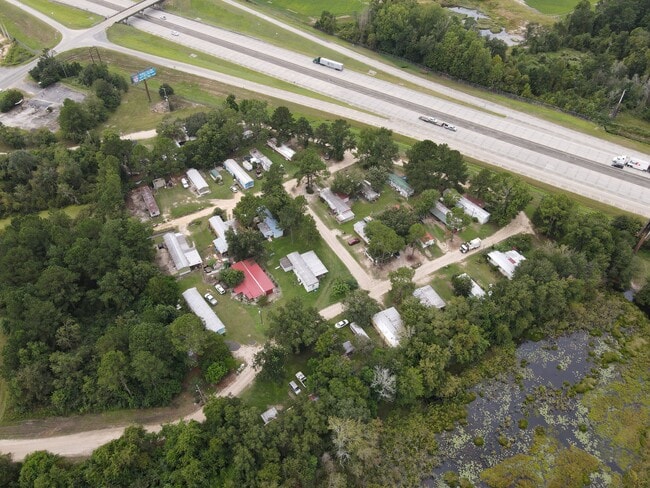

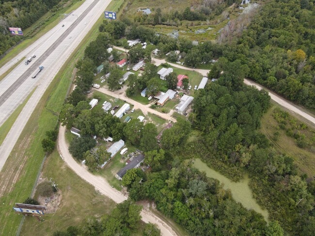
This Property Is For Sale
Property Detail
David St
0040E-009 01
LL 376-2
Commercialnec
COOK
HI
Georgia
B and X Area of moderate flood hazard, usually the area between the limits of the 100-year and 500-year floods.
330
2025
5.85 AC
2025
Valdosta/Lake Park
960400
Other Market Areas
NEARBY LISTINGS FOR SALE OR LEASE
-
-
View all Adel listings for sale on LoopNet.com
DEMOGRAPHICS near David St
1 mile
3 mile
5 mile
2025 Total Population
777
6,683
11,783
2030 Population
822
7,075
12,437
Pop Growth 2025-2030
+ 5.79%
+ 5.87%
+ 5.55%
Average Age
38
39
39
2025 Total Households
292
2,526
4,396
HH Growth 2025-2030
+ 5.82%
+ 5.90%
+ 5.57%
Median Household Inc
$39,696
$41,038
$45,957
Avg Household Size
2.60
2.50
2.60
2025 Avg HH Vehicles
2.00
2.00
2.00
Median Home Value
$150,819
$129,139
$142,231
Median Year Built
1990
1983
1987
Nearby Places
Map Layers
Map Styles
 Street
 Aerial
Transit
 Traffic
 Biking
Places
Listings with unknown addresses are not visible on the map
- Restaurants
- Banks
- Shops
- Fitness
- Groceries
PUBLIC TRANSPORTATION
AIRPORT
Valdosta Regional
Drive
Walk
Distance
Valdosta Regional
33 min
26.8 mi
Freight Ports
Georgia Ports - Brunswick
Drive
Walk
Distance
Georgia Ports - Brunswick
172 min
129.9 mi
Nearby Properties
Address
Land Use
TOTAL SIZE
Lot Size
Zoning
Address
Land Use
TOTAL SIZE
Lot Size
Zoning
31,118 SF
140.05 AC
Address
Land Use
TOTAL SIZE
Lot Size
Zoning
391,614 SF
160.24 AC
HI
Address
Land Use
TOTAL SIZE
Lot Size
Zoning
19,129 SF
93.78 AC
B1
Address
Land Use
TOTAL SIZE
Lot Size
Zoning
125,719 SF
10.16 AC
Address
Land Use
TOTAL SIZE
Lot Size
Zoning
11,604 SF
7.43 AC
R10
Address
Land Use
TOTAL SIZE
Lot Size
Zoning
27,830 SF
48.14 AC
B1
Address
Land Use
TOTAL SIZE
Lot Size
Zoning
4,000 SF
265.82 AC
WLI
Address
Land Use
TOTAL SIZE
Lot Size
Zoning
25,346 SF
11.65 AC
WLI
Address
Land Use
TOTAL SIZE
Lot Size
Zoning
46,102 SF
3.67 AC
RP
Address
Land Use
TOTAL SIZE
Lot Size
Zoning
8,188 SF
1.08 AC
RP
Address
Land Use
TOTAL SIZE
Lot Size
Zoning
60,000 SF
20.82 AC
HI
Address
Land Use
TOTAL SIZE
Lot Size
Zoning
56,952 SF
16.42 AC
HI
Address
Land Use
TOTAL SIZE
Lot Size
Zoning
20,100 SF
5.41 AC
RP
Address
Land Use
TOTAL SIZE
Lot Size
Zoning
2,718 SF
62.71 AC
GB
Address
Land Use
TOTAL SIZE
Lot Size
Zoning
197,890 SF
55.63 AC
WLI
Address
Land Use
TOTAL SIZE
Lot Size
Zoning
25,894 SF
2.89 AC
GB
Address
Land Use
TOTAL SIZE
Lot Size
Zoning
10,475 SF
4.65 AC
R10
Address
Land Use
TOTAL SIZE
Lot Size
Zoning
7,828 SF
8.23 AC
HI
Address
Land Use
TOTAL SIZE
Lot Size
Zoning
35,550 SF
6.20 AC
GB
Address
Land Use
TOTAL SIZE
Lot Size
Zoning
1,850 SF
71.40 AC
GB
Address
Land Use
TOTAL SIZE
Lot Size
Zoning
19,827 SF
0.80 AC
GB
Address
Land Use
TOTAL SIZE
Lot Size
Zoning
6,985 SF
31.29 AC
HI
Address
Land Use
TOTAL SIZE
Lot Size
Zoning
20,000 SF
10 AC
Address
Land Use
TOTAL SIZE
Lot Size
Zoning
41,132 SF
8.46 AC
HI
Address
Land Use
TOTAL SIZE
Lot Size
Zoning
24,400 SF
56.47 AC
Address
Land Use
TOTAL SIZE
Lot Size
Zoning
25,902 SF
2.79 AC
RP
Address
Land Use
TOTAL SIZE
Lot Size
Zoning
4,420 SF
0.90 AC
RP
Address
Land Use
TOTAL SIZE
Lot Size
Zoning
34,503 SF
3.86 AC
GB
The World's #1 Commercial Real Estate Marketplace
Connect with us
© 2026 CoStar Group
The information above has been obtained from sources believed reliable. While we do not doubt its accuracy we have not verified it and make no guarantee, warranty or representation about it. It is your responsibility to independently confirm its accuracy and completeness. Any projections, opinions, assumptions, or estimates used are for example only and do not represent the current or future performance of the property. The value of this transaction to you depends on tax and other factors which should be evaluated by your tax, financial, and legal advisors. You and your advisors should conduct a careful, independent investigation of the property to determine to your satisfaction the suitability of the property for your needs.