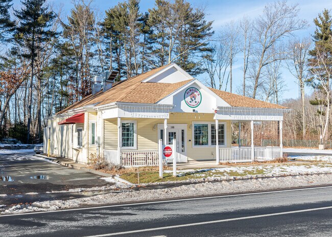
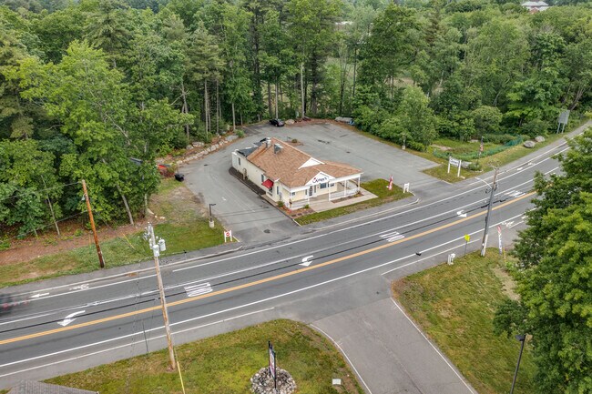
Property Record
146 State St, Belchertown, MA 01007

Property Detail
146 State St
Amherst Town-Northampton, MA
Hampshire
BELC-000250-000000-000058-000001
Massachusetts
Taxexempt
58
B1
3.77 AC
0
Hampshire County
2025
Hartford
820207
NEARBY LISTINGS FOR SALE OR LEASE
DEMOGRAPHICS near 146 State St
1 mile
3 mile
5 mile
2025 Total Population
1,230
10,637
17,341
2030 Population
1,217
10,564
17,246
Pop Growth 2025-2030
(1.06%)
(0.69%)
(0.55%)
Average Age
43
43
43
2025 Total Households
529
4,325
6,821
HH Growth 2025-2030
(0.95%)
(0.49%)
(0.38%)
Median Household Inc
$73,928
$90,149
$94,798
Avg Household Size
2.30
2.40
2.50
2025 Avg HH Vehicles
2.00
2.00
2.00
Median Home Value
$358,715
$364,169
$370,175
Median Year Built
1983
1985
1984
Nearby Places
Map Layers
Map Styles
 Street
 Aerial
Layers
 Traffic
 Biking
Places
Listings with unknown addresses are not visible on the map
- Restaurants
- Banks
- Shops
- Fitness
- Groceries
PUBLIC TRANSPORTATION
AIRPORT
Bradley International
Drive
Walk
Distance
Bradley International
64 min
31.6 mi
Worcester Regional
Drive
Walk
Distance
Worcester Regional
70 min
37.3 mi
SALE & LEASE HISTORY
LISTING DATE
SALE/LEASE

Sep 06, 2023
For Sale
Jul 26, 2024
For Sale
Jul 07, 2023
For Sale
Feb 25, 2025
For Sale
Feb 01, 2022
For Sale
Nearby Properties
Address
Land Use
TOTAL SIZE
Lot Size
Zoning
Address
Land Use
TOTAL SIZE
Lot Size
Zoning
178,173 SF
46.03 AC
Address
Land Use
TOTAL SIZE
Lot Size
Zoning
87,896 SF
12.65 AC
Address
Land Use
TOTAL SIZE
Lot Size
Zoning
2,295.68 AC
AGA
Address
Land Use
TOTAL SIZE
Lot Size
Zoning
72,521 SF
14.98 AC
Address
Land Use
TOTAL SIZE
Lot Size
Zoning
347.63 AC
AGA
Address
Land Use
TOTAL SIZE
Lot Size
Zoning
197 AC
AGA
Address
Land Use
TOTAL SIZE
Lot Size
Zoning
30,000 SF
13.88 AC
Address
Land Use
TOTAL SIZE
Lot Size
Zoning
57,801 SF
8.73 AC
GB2
Address
Land Use
TOTAL SIZE
Lot Size
Zoning
60,270 SF
17.83 AC
Address
Land Use
TOTAL SIZE
Lot Size
Zoning
5,520 SF
12.33 AC
Address
Land Use
TOTAL SIZE
Lot Size
Zoning
6.96 AC
Address
Land Use
TOTAL SIZE
Lot Size
Zoning
38,676 SF
10.40 AC
Address
Land Use
TOTAL SIZE
Lot Size
Zoning
54,099 SF
3.18 AC
BNC
Address
Land Use
TOTAL SIZE
Lot Size
Zoning
28.35 AC
Address
Land Use
TOTAL SIZE
Lot Size
Zoning
6.36 AC
OR2
Address
Land Use
TOTAL SIZE
Lot Size
Zoning
20.74 AC
Address
Land Use
TOTAL SIZE
Lot Size
Zoning
7.20 AC
Address
Land Use
TOTAL SIZE
Lot Size
Zoning
7.59 AC
GB2
Address
Land Use
TOTAL SIZE
Lot Size
Zoning
1.24 AC
Address
Land Use
TOTAL SIZE
Lot Size
Zoning
32,251 SF
2.40 AC
Address
Land Use
TOTAL SIZE
Lot Size
Zoning
5.16 AC
Address
Land Use
TOTAL SIZE
Lot Size
Zoning
12.12 AC
Address
Land Use
TOTAL SIZE
Lot Size
Zoning
19,520 SF
4.03 AC
Address
Land Use
TOTAL SIZE
Lot Size
Zoning
10.50 AC
Address
Land Use
TOTAL SIZE
Lot Size
Zoning
20.39 AC
I
Address
Land Use
TOTAL SIZE
Lot Size
Zoning
670 AC
AGA
Address
Land Use
TOTAL SIZE
Lot Size
Zoning
45.55 AC
I
Address
Land Use
TOTAL SIZE
Lot Size
Zoning
3,204 SF
158.35 AC
Address
Land Use
TOTAL SIZE
Lot Size
Zoning
4,554 SF
0.90 AC
Address
Land Use
TOTAL SIZE
Lot Size
Zoning
10,757 SF
2.19 AC
The World's #1 Commercial Real Estate Marketplace
Connect with us
© 2026 CoStar Group
The information above has been obtained from sources believed reliable. While we do not doubt its accuracy we have not verified it and make no guarantee, warranty or representation about it. It is your responsibility to independently confirm its accuracy and completeness. Any projections, opinions, assumptions, or estimates used are for example only and do not represent the current or future performance of the property. The value of this transaction to you depends on tax and other factors which should be evaluated by your tax, financial, and legal advisors. You and your advisors should conduct a careful, independent investigation of the property to determine to your satisfaction the suitability of the property for your needs.