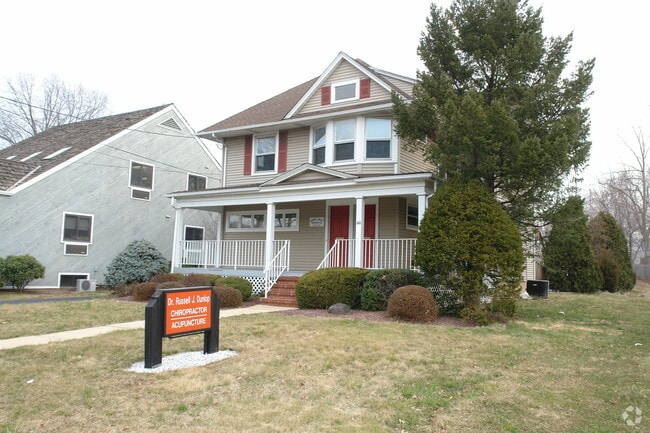
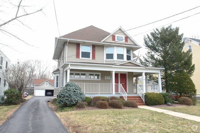
Property Record
146 W End Ave, Somerville, NJ 08876
NEARBY LISTINGS FOR SALE OR LEASE
Property Detail
146 W End Ave
18-00137-0000-00022
Somerset
Commercialnec
New Jersey
X
22
34035C0153E
0.28 AC
2024
Route 22 West
2025
Northern New Jersey
050100
Newark, NJ-PA
2,184 SF
DEMOGRAPHICS near 146 W End Ave
1 Mile
3 Mile
5 Mile
2024 Total Population
14,393
62,947
123,125
2029 Population
14,680
63,325
123,290
Pop Growth 2024-2029
+ 1.99%
+ 0.60%
+ 0.13%
Average Age
39
41
42
2024 Total Households
6,017
23,319
45,342
HH Growth 2024-2029
+ 2.13%
+ 0.65%
+ 0.17%
Median Household Inc
$85,014
$111,151
$117,623
Avg Household Size
2.30
2.60
2.60
2024 Avg HH Vehicles
2.00
2.00
2.00
Median Home Value
$367,766
$419,581
$447,183
Median Year Built
1962
1972
1976
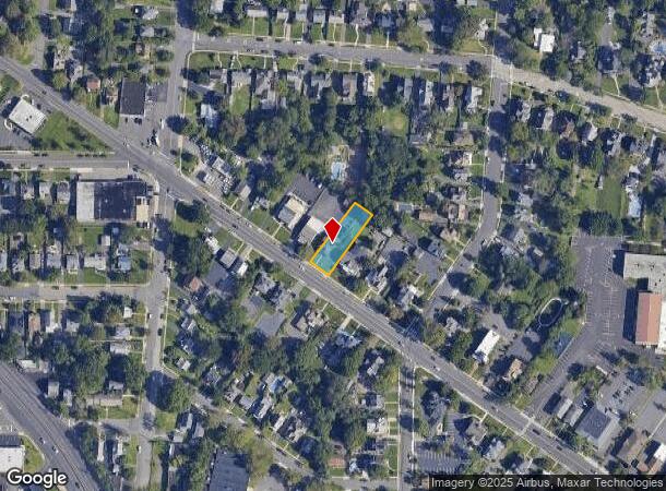
Nearby Places
Map Layers
Map Styles
 Street
 Aerial
- Restaurants
- Banks
- Shops
- Fitness
- Groceries
PUBLIC TRANSPORTATION
TRANSIT/SUBWAY
Raritan (Raritan Valley Line - NJ Transit Commuter Rail (NJ Transit))
DRIVE
WALK
Distance
Raritan (Raritan Valley Line - NJ Transit Commuter Rail (NJ Transit))
3 min
15 min
0.8 mi
Somerville (Raritan Valley Line - NJ Transit Commuter Rail (NJ Transit))
DRIVE
WALK
Distance
Somerville (Raritan Valley Line - NJ Transit Commuter Rail (NJ Transit))
4 min
17 min
0.9 mi
COMMUTER RAIL
Raritan (Raritan Valley Line - NJ Transit Commuter Rail (NJ Transit))
DRIVE
WALK
Distance
Raritan (Raritan Valley Line - NJ Transit Commuter Rail (NJ Transit))
3 min
15 min
0.8 mi
Somerville (Raritan Valley Line - NJ Transit Commuter Rail (NJ Transit))
DRIVE
WALK
Distance
Somerville (Raritan Valley Line - NJ Transit Commuter Rail (NJ Transit))
3 min
17 min
0.8 mi
AIRPORT
Trenton Mercer
DRIVE
WALK
Distance
Trenton Mercer
52 min
28.2 mi
Newark Liberty International
DRIVE
WALK
Distance
Newark Liberty International
42 min
34.3 mi
Freight Ports
New York Container Terminal
DRIVE
WALK
Distance
New York Container Terminal
43 min
33.4 mi
Nearby Properties
Address
Land Use
TOTAL SIZE
Lot Size
Zoning
Address
Land Use
TOTAL SIZE
Lot Size
Zoning
26.42 AC
C2
Address
Land Use
TOTAL SIZE
Lot Size
Zoning
108.74 AC
OM-3
Address
Land Use
TOTAL SIZE
Lot Size
Zoning
13.59 AC
H
Address
Land Use
TOTAL SIZE
Lot Size
Zoning
39.10 AC
C3
Address
Land Use
TOTAL SIZE
Lot Size
Zoning
47.50 AC
M1
Address
Land Use
TOTAL SIZE
Lot Size
Zoning
54.31 AC
P-2
Address
Land Use
TOTAL SIZE
Lot Size
Zoning
153 AC
Address
Land Use
TOTAL SIZE
Lot Size
Zoning
25.70 AC
PACD
Address
Land Use
TOTAL SIZE
Lot Size
Zoning
81.89 AC
M1
Address
Land Use
TOTAL SIZE
Lot Size
Zoning
Address
Land Use
TOTAL SIZE
Lot Size
Zoning
66.08 AC
M3
Address
Land Use
TOTAL SIZE
Lot Size
Zoning
34.80 AC
OM-3
Address
Land Use
TOTAL SIZE
Lot Size
Zoning
82.79 AC
M-2
Address
Land Use
TOTAL SIZE
Lot Size
Zoning
19.34 AC
M1
Address
Land Use
TOTAL SIZE
Lot Size
Zoning
19.36 AC
M1
Address
Land Use
TOTAL SIZE
Lot Size
Zoning
33.16 AC
M3
Address
Land Use
TOTAL SIZE
Lot Size
Zoning
10.31 AC
PDRD
Address
Land Use
TOTAL SIZE
Lot Size
Zoning
5.60 AC
CG
Address
Land Use
TOTAL SIZE
Lot Size
Zoning
8.26 AC
R40
Address
Land Use
TOTAL SIZE
Lot Size
Zoning
1,056 SF
0.07 AC
Address
Land Use
TOTAL SIZE
Lot Size
Zoning
10.47 AC
C2
Address
Land Use
TOTAL SIZE
Lot Size
Zoning
9.91 AC
C2
Address
Land Use
TOTAL SIZE
Lot Size
Zoning
8.60 AC
C2
Address
Land Use
TOTAL SIZE
Lot Size
Zoning
34.26 AC
Address
Land Use
TOTAL SIZE
Lot Size
Zoning
394 SF
36.05 AC
M105
Address
Land Use
TOTAL SIZE
Lot Size
Zoning
43.63 AC
M1B
Address
Land Use
TOTAL SIZE
Lot Size
Zoning
19.95 AC
M1B
Address
Land Use
TOTAL SIZE
Lot Size
Zoning
12.53 AC
M1
Address
Land Use
TOTAL SIZE
Lot Size
Zoning
18.99 AC
M1
Address
Land Use
TOTAL SIZE
Lot Size
Zoning
28.44 AC
C2
The World's #1 Commercial Real Estate Marketplace
Connect with us
© 2025 CoStar Group
The information above has been obtained from sources believed reliable. While we do not doubt its accuracy we have not verified it and make no guarantee, warranty or representation about it. It is your responsibility to independently confirm its accuracy and completeness. Any projections, opinions, assumptions, or estimates used are for example only and do not represent the current or future performance of the property. The value of this transaction to you depends on tax and other factors which should be evaluated by your tax, financial, and legal advisors. You and your advisors should conduct a careful, independent investigation of the property to determine to your satisfaction the suitability of the property for your needs.