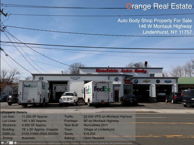
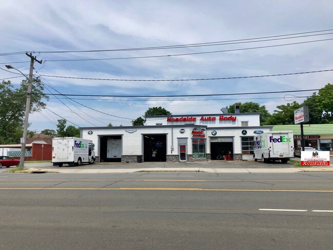
Property Record
146 W Montauk Hwy, Lindenhurst, NY 11757
NEARBY LISTINGS FOR SALE OR LEASE
Property Detail
146 W Montauk Hwy
0103-018-00-05-00-062-000
FILED MAP 2-282 BLK 14 LTS 7-9 & P/O 10
Vehiclerentalsvehiclesales
Suffolk
X
New York
36103C0861H
62
2024
0.25 AC
2024
Southwestern Suffolk
124102
Long Island (New York)
4,311 SF
Nassau County-Suffolk County, NY
DEMOGRAPHICS near 146 W Montauk Hwy
1 Mile
3 Mile
5 Mile
2024 Total Population
19,356
105,632
227,583
2029 Population
18,970
103,138
222,767
Pop Growth 2024-2029
(1.99%)
(2.36%)
(2.12%)
Average Age
42
41
41
2024 Total Households
6,714
35,870
75,168
HH Growth 2024-2029
(2.10%)
(2.56%)
(2.31%)
Median Household Inc
$104,451
$106,559
$114,303
Avg Household Size
2.80
2.80
2.90
2024 Avg HH Vehicles
2.00
2.00
2.00
Median Home Value
$444,034
$450,275
$476,051
Median Year Built
1957
1960
1959
Nearby Places
- Restaurants
- Banks
- Shops
- Fitness
- Groceries
PUBLIC TRANSPORTATION
COMMUTER RAIL
Lindenhurst Station (Babylon Branch - Long Island Rail Road)
DRIVE
WALK
Distance
Lindenhurst Station (Babylon Branch - Long Island Rail Road)
3 min
1.4 mi
Copiague Station (Babylon Branch - Long Island Rail Road)
DRIVE
WALK
Distance
Copiague Station (Babylon Branch - Long Island Rail Road)
4 min
2.4 mi
AIRPORT
Long Island MacArthur
DRIVE
WALK
Distance
Long Island MacArthur
28 min
19.2 mi
John F Kennedy International
DRIVE
WALK
Distance
John F Kennedy International
37 min
25.5 mi
LaGuardia
DRIVE
WALK
Distance
LaGuardia
47 min
32.5 mi
Freight Ports
NY - Red Hook Container Terminal
DRIVE
WALK
Distance
NY - Red Hook Container Terminal
58 min
36.9 mi
SALE & LEASE HISTORY
LISTING DATE
SALE/LEASE

Jun 09, 2017
For Sale
Jul 27, 2018
For Sale
Jan 19, 2022
For Sale
Nearby Properties
Address
Land Use
TOTAL SIZE
Lot Size
Zoning
Address
Land Use
TOTAL SIZE
Lot Size
Zoning
4,290 SF
1.50 AC
VILLA
Address
Land Use
TOTAL SIZE
Lot Size
Zoning
9.95 AC
BUS3
Address
Land Use
TOTAL SIZE
Lot Size
Zoning
24.90 AC
B
Address
Land Use
TOTAL SIZE
Lot Size
Zoning
3,518 SF
0.44 AC
VILLA
Address
Land Use
TOTAL SIZE
Lot Size
Zoning
6.37 AC
BUS3
Address
Land Use
TOTAL SIZE
Lot Size
Zoning
2,520 SF
0.89 AC
HC
Address
Land Use
TOTAL SIZE
Lot Size
Zoning
1.70 AC
R40
Address
Land Use
TOTAL SIZE
Lot Size
Zoning
5,010 SF
0.30 AC
R10
Address
Land Use
TOTAL SIZE
Lot Size
Zoning
22.10 AC
Address
Land Use
TOTAL SIZE
Lot Size
Zoning
0.99 AC
HB
Address
Land Use
TOTAL SIZE
Lot Size
Zoning
0.90 AC
HC
Address
Land Use
TOTAL SIZE
Lot Size
Zoning
7.15 AC
Address
Land Use
TOTAL SIZE
Lot Size
Zoning
6,891 SF
0.75 AC
HC
Address
Land Use
TOTAL SIZE
Lot Size
Zoning
13.63 AC
B
Address
Land Use
TOTAL SIZE
Lot Size
Zoning
0.65 AC
R40
Address
Land Use
TOTAL SIZE
Lot Size
Zoning
Address
Land Use
TOTAL SIZE
Lot Size
Zoning
44 AC
E
Address
Land Use
TOTAL SIZE
Lot Size
Zoning
9.68 AC
SC
Address
Land Use
TOTAL SIZE
Lot Size
Zoning
3.80 AC
BUS1
Address
Land Use
TOTAL SIZE
Lot Size
Zoning
163.50 AC
A
Address
Land Use
TOTAL SIZE
Lot Size
Zoning
12.50 AC
C
Address
Land Use
TOTAL SIZE
Lot Size
Zoning
18.30 AC
Address
Land Use
TOTAL SIZE
Lot Size
Zoning
Address
Land Use
TOTAL SIZE
Lot Size
Zoning
135,605 SF
15.05 AC
E
Address
Land Use
TOTAL SIZE
Lot Size
Zoning
1,450 SF
0.08 AC
Address
Land Use
TOTAL SIZE
Lot Size
Zoning
0.63 AC
R20
Address
Land Use
TOTAL SIZE
Lot Size
Zoning
13.20 AC
CR80
Address
Land Use
TOTAL SIZE
Lot Size
Zoning
126,000 SF
4.12 AC
E
Address
Land Use
TOTAL SIZE
Lot Size
Zoning
1.64 AC
IND1
Address
Land Use
TOTAL SIZE
Lot Size
Zoning
1.08 AC
CR200
The World's #1 Commercial Real Estate Marketplace
Connect with us
© 2025 CoStar Group
The information above has been obtained from sources believed reliable. While we do not doubt its accuracy we have not verified it and make no guarantee, warranty or representation about it. It is your responsibility to independently confirm its accuracy and completeness. Any projections, opinions, assumptions, or estimates used are for example only and do not represent the current or future performance of the property. The value of this transaction to you depends on tax and other factors which should be evaluated by your tax, financial, and legal advisors. You and your advisors should conduct a careful, independent investigation of the property to determine to your satisfaction the suitability of the property for your needs.