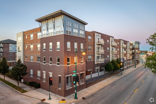
Property Record
1460 Six Points Xing, Milwaukee, WI 53214
NEARBY LISTINGS FOR SALE OR LEASE
Property Detail
1460 Six Points Xing
Milwaukee-Waukesha-West Allis, WI
C A Maynard & Agnew S Subdivision No 3
454-0637-001
CERTIFIED SURVEY MAP NO 7779 NE 1/4 SEC 3-6-21 LOT 2
Commercialnec
Milwaukee
X
Wisconsin
55079C0088E
2
2024
1.53 AC
2024
Wauwatosa/West Allis
100200
Milwaukee/Madison
DEMOGRAPHICS near 1460 Six Points Xing
1 Mile
3 Mile
5 Mile
2024 Total Population
23,580
173,515
447,529
2029 Population
23,097
169,368
439,430
Pop Growth 2024-2029
(2.05%)
(2.39%)
(1.81%)
Average Age
38
38
37
2024 Total Households
10,518
73,333
186,061
HH Growth 2024-2029
(2.07%)
(2.40%)
(1.81%)
Median Household Inc
$54,505
$57,224
$55,200
Avg Household Size
2.10
2.30
2.30
2024 Avg HH Vehicles
2.00
2.00
1.00
Median Home Value
$160,096
$176,182
$188,783
Median Year Built
1948
1949
1951
Nearby Places
Map Layers
Map Styles
 Street
 Aerial
- Restaurants
- Banks
- Shops
- Fitness
- Groceries
PUBLIC TRANSPORTATION
COMMUTER RAIL
Milwaukee (Empire Builder - Amtrak)
DRIVE
WALK
Distance
Milwaukee (Empire Builder - Amtrak)
9 min
4.9 mi
General Mitchell Intl. Airport Amtrak Station (Hiawatha Service - Amtrak)
DRIVE
WALK
Distance
General Mitchell Intl. Airport Amtrak Station (Hiawatha Service - Amtrak)
21 min
9.2 mi
AIRPORT
General Mitchell International
DRIVE
WALK
Distance
General Mitchell International
21 min
11.6 mi
Freight Ports
Port Milwaukee
DRIVE
WALK
Distance
Port Milwaukee
14 min
7.4 mi
SALE & LEASE HISTORY
LISTING DATE
SALE/LEASE

Sep 25, 2016
For Lease
Oct 21, 2020
For Lease
Mar 31, 2021
For Sale
Mar 23, 2021
For Sale
Nearby Properties
Address
Land Use
TOTAL SIZE
Lot Size
Zoning
Address
Land Use
TOTAL SIZE
Lot Size
Zoning
8.63 AC
C2
Address
Land Use
TOTAL SIZE
Lot Size
Zoning
36.11 AC
Address
Land Use
TOTAL SIZE
Lot Size
Zoning
122.53 AC
TL
Address
Land Use
TOTAL SIZE
Lot Size
Zoning
23.16 AC
Address
Land Use
TOTAL SIZE
Lot Size
Zoning
13.48 AC
Address
Land Use
TOTAL SIZE
Lot Size
Zoning
5.12 AC
Address
Land Use
TOTAL SIZE
Lot Size
Zoning
Address
Land Use
TOTAL SIZE
Lot Size
Zoning
68.35 AC
TL
Address
Land Use
TOTAL SIZE
Lot Size
Zoning
Address
Land Use
TOTAL SIZE
Lot Size
Zoning
8,881 SF
7.52 AC
Address
Land Use
TOTAL SIZE
Lot Size
Zoning
13.39 AC
Address
Land Use
TOTAL SIZE
Lot Size
Zoning
9.33 AC
PUD
Address
Land Use
TOTAL SIZE
Lot Size
Zoning
47.96 AC
TL
Address
Land Use
TOTAL SIZE
Lot Size
Zoning
3.74 AC
PUD
Address
Land Use
TOTAL SIZE
Lot Size
Zoning
Address
Land Use
TOTAL SIZE
Lot Size
Zoning
39.81 AC
Address
Land Use
TOTAL SIZE
Lot Size
Zoning
8.78 AC
Address
Land Use
TOTAL SIZE
Lot Size
Zoning
0.36 AC
Address
Land Use
TOTAL SIZE
Lot Size
Zoning
20.61 AC
TL
Address
Land Use
TOTAL SIZE
Lot Size
Zoning
132,289 SF
5.34 AC
PD
Address
Land Use
TOTAL SIZE
Lot Size
Zoning
12.47 AC
Address
Land Use
TOTAL SIZE
Lot Size
Zoning
35.55 AC
INSTITUTIO
Address
Land Use
TOTAL SIZE
Lot Size
Zoning
4.63 AC
IO2
Address
Land Use
TOTAL SIZE
Lot Size
Zoning
164,825 SF
7.93 AC
PD
Address
Land Use
TOTAL SIZE
Lot Size
Zoning
7.55 AC
SP-INS
Address
Land Use
TOTAL SIZE
Lot Size
Zoning
159,673 SF
6.69 AC
PD
Address
Land Use
TOTAL SIZE
Lot Size
Zoning
113,300 SF
5.60 AC
IL1
Address
Land Use
TOTAL SIZE
Lot Size
Zoning
61,940 SF
1 AC
RM5
Address
Land Use
TOTAL SIZE
Lot Size
Zoning
2.03 AC
The World's #1 Commercial Real Estate Marketplace
Connect with us
© 2025 CoStar Group
The information above has been obtained from sources believed reliable. While we do not doubt its accuracy we have not verified it and make no guarantee, warranty or representation about it. It is your responsibility to independently confirm its accuracy and completeness. Any projections, opinions, assumptions, or estimates used are for example only and do not represent the current or future performance of the property. The value of this transaction to you depends on tax and other factors which should be evaluated by your tax, financial, and legal advisors. You and your advisors should conduct a careful, independent investigation of the property to determine to your satisfaction the suitability of the property for your needs.