Property Record
1460 W Nevada Highway 372, Pahrump, NV 89048

NEARBY LISTINGS FOR SALE OR LEASE
Property Detail
1460 W Nevada Highway 372
Pahrump, NV
Horgan Ros
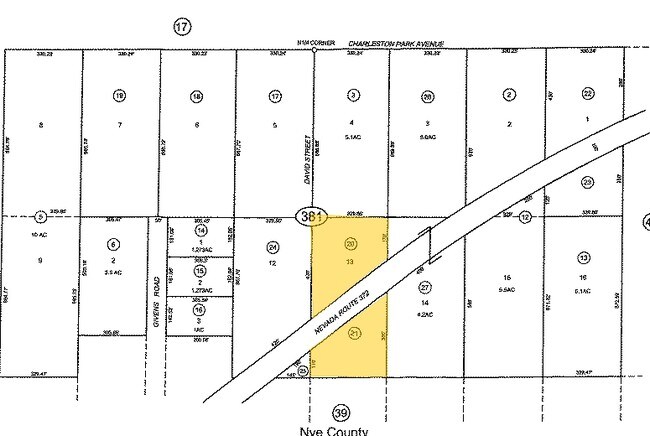
36-381-20
T20S R53E S20 LOT 13 S OF HIGHWAY 2.0AC HORGAN ROS
Commercialacreage
Nye
X
Nevada
32023C8825F
13
2024
2 AC
2025
Carson City/Nevada Area
960408
Other Market Areas
DEMOGRAPHICS near 1460 W Nevada Highway 372
1 Mile
3 Mile
5 Mile
2024 Total Population
1,459
16,805
26,990
2029 Population
1,703
19,561
31,378
Pop Growth 2024-2029
+ 16.72%
+ 16.40%
+ 16.26%
Average Age
50
49
49
2024 Total Households
627
7,306
11,477
HH Growth 2024-2029
+ 16.91%
+ 16.51%
+ 16.41%
Median Household Inc
$46,094
$51,250
$51,886
Avg Household Size
2.30
2.30
2.30
2024 Avg HH Vehicles
2.00
2.00
2.00
Median Home Value
$241,964
$237,984
$247,587
Median Year Built
1994
1996
1996
Nearby Places
Map Layers
Map Styles
 Street
 Aerial
- Restaurants
- Banks
- Shops
- Fitness
- Groceries
Nearby Properties
Address
Land Use
TOTAL SIZE
Lot Size
Zoning
Address
Land Use
TOTAL SIZE
Lot Size
Zoning
133,185 SF
41.60 AC
CF
Address
Land Use
TOTAL SIZE
Lot Size
Zoning
51,128 SF
24.15 AC
M
Address
Land Use
TOTAL SIZE
Lot Size
Zoning
156,375 SF
13.60 AC
GC
Address
Land Use
TOTAL SIZE
Lot Size
Zoning
62,279 SF
7.09 AC
GC
Address
Land Use
TOTAL SIZE
Lot Size
Zoning
10 SF
2.14 AC
OS
Address
Land Use
TOTAL SIZE
Lot Size
Zoning
12,000 SF
9.54 AC
CF
Address
Land Use
TOTAL SIZE
Lot Size
Zoning
38,606 SF
10 AC
CF
Address
Land Use
TOTAL SIZE
Lot Size
Zoning
16,466 SF
2.15 AC
GC
Address
Land Use
TOTAL SIZE
Lot Size
Zoning
20,053 SF
4.61 AC
CF
Address
Land Use
TOTAL SIZE
Lot Size
Zoning
10,282 SF
34.27 AC
OS
Address
Land Use
TOTAL SIZE
Lot Size
Zoning
13,885 SF
2.01 AC
M
Address
Land Use
TOTAL SIZE
Lot Size
Zoning
18,746 SF
5.08 AC
NC
Address
Land Use
TOTAL SIZE
Lot Size
Zoning
12,160 SF
1.26 AC
M
Address
Land Use
TOTAL SIZE
Lot Size
Zoning
25,000 SF
4.23 AC
GC
Address
Land Use
TOTAL SIZE
Lot Size
Zoning
14,027 SF
1.56 AC
GC
Address
Land Use
TOTAL SIZE
Lot Size
Zoning
12,000 SF
5 AC
CM
Address
Land Use
TOTAL SIZE
Lot Size
Zoning
24,154 SF
1.38 AC
GC
Address
Land Use
TOTAL SIZE
Lot Size
Zoning
7,656 SF
5.75 AC
CF
Address
Land Use
TOTAL SIZE
Lot Size
Zoning
8,400 SF
2.17 AC
GC
Address
Land Use
TOTAL SIZE
Lot Size
Zoning
9,292 SF
1.06 AC
GC
Address
Land Use
TOTAL SIZE
Lot Size
Zoning
17,070 SF
2.11 AC
GC
Address
Land Use
TOTAL SIZE
Lot Size
Zoning
19,097 SF
4.25 AC
GC
Address
Land Use
TOTAL SIZE
Lot Size
Zoning
4,931 SF
1.21 AC
GC
Address
Land Use
TOTAL SIZE
Lot Size
Zoning
1,200 SF
10.02 AC
CF
Address
Land Use
TOTAL SIZE
Lot Size
Zoning
20,000 SF
4.60 AC
LI
Address
Land Use
TOTAL SIZE
Lot Size
Zoning
9,564 SF
8.51 AC
CF
Address
Land Use
TOTAL SIZE
Lot Size
Zoning
19,543 SF
1.47 AC
GC
Address
Land Use
TOTAL SIZE
Lot Size
Zoning
11,813 SF
1.30 AC
GC
Address
Land Use
TOTAL SIZE
Lot Size
Zoning
8,750 SF
2.04 AC
CF
Address
Land Use
TOTAL SIZE
Lot Size
Zoning
10,899 SF
5 AC
NC
The World's #1 Commercial Real Estate Marketplace
Connect with us
© 2025 CoStar Group
The information above has been obtained from sources believed reliable. While we do not doubt its accuracy we have not verified it and make no guarantee, warranty or representation about it. It is your responsibility to independently confirm its accuracy and completeness. Any projections, opinions, assumptions, or estimates used are for example only and do not represent the current or future performance of the property. The value of this transaction to you depends on tax and other factors which should be evaluated by your tax, financial, and legal advisors. You and your advisors should conduct a careful, independent investigation of the property to determine to your satisfaction the suitability of the property for your needs.