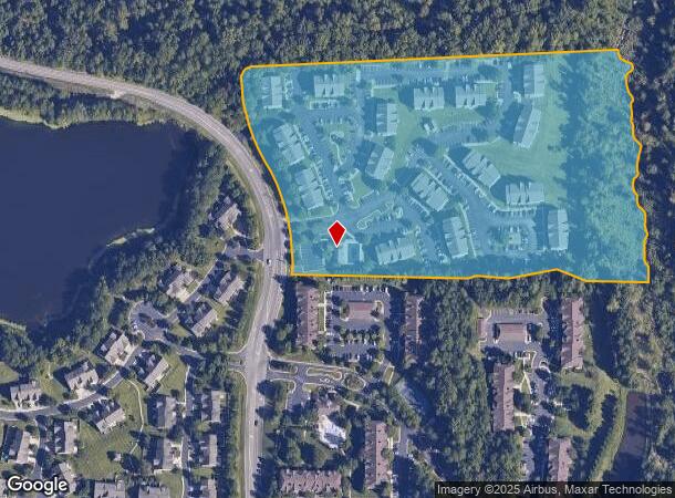
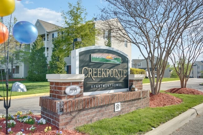
Property Record
14600 Creekpointe Cir, Midlothian, VA 23114


NEARBY LISTINGS FOR SALE OR LEASE
-
-
View all Midlothian listings for sale on LoopNet.com
Property Detail
14600 Creekpointe Cir
722-69-46-65-800-000
E/L Old Hundred Road
Apartment
E/L OLD HUNDRED ROAD
AE
Chesterfield
51145C0300C
Virginia
0
15 AC
2025
Midlothian
100928
Richmond VA
100 SF
Richmond, VA
DEMOGRAPHICS near 14600 Creekpointe Cir
1 Mile
3 Mile
5 Mile
2024 Total Population
6,659
43,791
112,831
2029 Population
7,462
48,366
124,180
Pop Growth 2024-2029
+ 12.06%
+ 10.45%
+ 10.06%
Average Age
39
40
40
2024 Total Households
2,514
16,108
41,867
HH Growth 2024-2029
+ 12.17%
+ 10.42%
+ 10.13%
Median Household Inc
$117,816
$113,164
$107,390
Avg Household Size
2.60
2.70
2.70
2024 Avg HH Vehicles
2.00
2.00
2.00
Median Home Value
$384,809
$373,574
$360,191
Median Year Built
2005
2000
1994
Nearby Places
Map Layers
Map Styles
 Street
 Aerial
- Restaurants
- Banks
- Shops
- Fitness
- Groceries
PUBLIC TRANSPORTATION
AIRPORT
Richmond International
DRIVE
WALK
Distance
Richmond International
39 min
27.0 mi
Freight Ports
Virginia Port Authority - Richmond
DRIVE
WALK
Distance
Virginia Port Authority - Richmond
31 min
17.4 mi
Nearby Properties
Address
Land Use
TOTAL SIZE
Lot Size
Zoning
Address
Land Use
TOTAL SIZE
Lot Size
Zoning
88,520 SF
28.29 AC
C3 - COMMU
Address
Land Use
TOTAL SIZE
Lot Size
Zoning
578,400 SF
6.77 AC
I2 - GEN I
Address
Land Use
TOTAL SIZE
Lot Size
Zoning
101,438 SF
63.19 AC
A - AGRICU
Address
Land Use
TOTAL SIZE
Lot Size
Zoning
5,720 SF
117.22 AC
R9 - SINGL
Address
Land Use
TOTAL SIZE
Lot Size
Zoning
5,922 SF
17.83 AC
RMF - RES,
Address
Land Use
TOTAL SIZE
Lot Size
Zoning
100 SF
17.82 AC
R7 - SINGL
Address
Land Use
TOTAL SIZE
Lot Size
Zoning
161,600 SF
18.40 AC
R7 - SINGL
Address
Land Use
TOTAL SIZE
Lot Size
Zoning
108,805 SF
21.09 AC
RMF - RES,
Address
Land Use
TOTAL SIZE
Lot Size
Zoning
136,718 SF
30.88 AC
RMF - RES,
Address
Land Use
TOTAL SIZE
Lot Size
Zoning
100 SF
8.12 AC
C3 - COMMU
Address
Land Use
TOTAL SIZE
Lot Size
Zoning
241,433 SF
68.39 AC
R15 - SING
Address
Land Use
TOTAL SIZE
Lot Size
Zoning
72,417 SF
11.76 AC
R7 - SINGL
Address
Land Use
TOTAL SIZE
Lot Size
Zoning
89,300 SF
32.90 AC
O2 - CORP
Address
Land Use
TOTAL SIZE
Lot Size
Zoning
29.24 AC
O2 - CORP
Address
Land Use
TOTAL SIZE
Lot Size
Zoning
174,840 SF
21.13 AC
R7 - SINGL
Address
Land Use
TOTAL SIZE
Lot Size
Zoning
113,384 SF
15.89 AC
R7 - SINGL
Address
Land Use
TOTAL SIZE
Lot Size
Zoning
99,934 SF
81.69 AC
A - AGRICU
Address
Land Use
TOTAL SIZE
Lot Size
Zoning
220,845 SF
8.36 AC
I1 - LT IN
Address
Land Use
TOTAL SIZE
Lot Size
Zoning
53,900 SF
7.70 AC
R12 - SING
Address
Land Use
TOTAL SIZE
Lot Size
Zoning
97,740 SF
20.97 AC
R7 - SINGL
Address
Land Use
TOTAL SIZE
Lot Size
Zoning
49,510 SF
8.86 AC
C3 - COMMU
Address
Land Use
TOTAL SIZE
Lot Size
Zoning
116,542 SF
38.82 AC
R7 - SINGL
Address
Land Use
TOTAL SIZE
Lot Size
Zoning
5,680 SF
6.75 AC
C2 - NBHD
Address
Land Use
TOTAL SIZE
Lot Size
Zoning
310.29 AC
C3 - COMMU
Address
Land Use
TOTAL SIZE
Lot Size
Zoning
111,778 SF
9.23 AC
C3 - COMMU
Address
Land Use
TOTAL SIZE
Lot Size
Zoning
73,969 SF
24.40 AC
R9 - SINGL
Address
Land Use
TOTAL SIZE
Lot Size
Zoning
93,925 SF
21.04 AC
A - AGRICU
Address
Land Use
TOTAL SIZE
Lot Size
Zoning
21,211 SF
3.53 AC
R7 - SINGL
Address
Land Use
TOTAL SIZE
Lot Size
Zoning
33,817 SF
1.71 AC
I1 - LT IN
The World's #1 Commercial Real Estate Marketplace
Connect with us
© 2026 CoStar Group
The information above has been obtained from sources believed reliable. While we do not doubt its accuracy we have not verified it and make no guarantee, warranty or representation about it. It is your responsibility to independently confirm its accuracy and completeness. Any projections, opinions, assumptions, or estimates used are for example only and do not represent the current or future performance of the property. The value of this transaction to you depends on tax and other factors which should be evaluated by your tax, financial, and legal advisors. You and your advisors should conduct a careful, independent investigation of the property to determine to your satisfaction the suitability of the property for your needs.