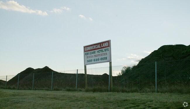
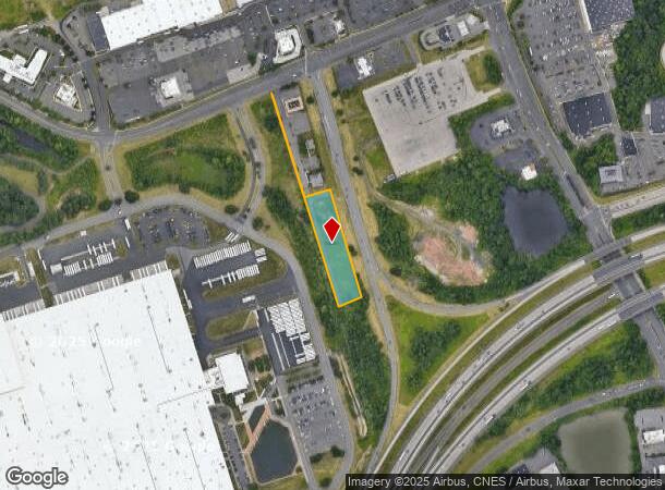
Property Record
1461 Pleasant Valley Rd, Manchester, CT 06042
NEARBY LISTINGS FOR SALE OR LEASE
Property Detail
1461 Pleasant Valley Rd
MANC-000026-004585-001461
Hartford
Commercialacreage
Connecticut
X
1461
09003C0391F
1.93 AC
2025
Manchester
2025
Hartford
514103
Hartford-West Hartford-East Hartford, CT
DEMOGRAPHICS near 1461 Pleasant Valley Rd
1 Mile
3 Mile
5 Mile
2024 Total Population
6,147
63,363
133,403
2029 Population
6,201
63,111
132,834
Pop Growth 2024-2029
+ 0.88%
(0.40%)
(0.43%)
Average Age
36
39
40
2024 Total Households
2,885
26,252
53,801
HH Growth 2024-2029
+ 0.83%
(0.45%)
(0.46%)
Median Household Inc
$99,023
$79,194
$81,863
Avg Household Size
2.10
2.30
2.40
2024 Avg HH Vehicles
1.00
2.00
2.00
Median Home Value
$270,478
$208,067
$236,328
Median Year Built
1995
1968
1966
Nearby Places
Map Layers
Map Styles
 Street
 Aerial
- Restaurants
- Banks
- Shops
- Fitness
- Groceries
PUBLIC TRANSPORTATION
COMMUTER RAIL
Hartford Amtrak Station (Amtrak Hartford Line - Amtrak, Northeast Regional - Amtrak, Valley Flyer - Amtrak, Vermonter - Amtrak)
DRIVE
WALK
Distance
Hartford Amtrak Station (Amtrak Hartford Line - Amtrak, Northeast Regional - Amtrak, Valley Flyer - Amtrak, Vermonter - Amtrak)
11 min
8.0 mi
Windsor (Amtrak Hartford Line - Amtrak, Hartford Line - Amtrak, Northeast Regional - Amtrak, Valley Flyer - Amtrak)
DRIVE
WALK
Distance
Windsor (Amtrak Hartford Line - Amtrak, Hartford Line - Amtrak, Northeast Regional - Amtrak, Valley Flyer - Amtrak)
16 min
8.5 mi
AIRPORT
Bradley International
DRIVE
WALK
Distance
Bradley International
34 min
17.8 mi
Freight Ports
Port of New Haven
DRIVE
WALK
Distance
Port of New Haven
58 min
44.5 mi
Nearby Properties
Address
Land Use
TOTAL SIZE
Lot Size
Zoning
Address
Land Use
TOTAL SIZE
Lot Size
Zoning
159 AC
RR
Address
Land Use
TOTAL SIZE
Lot Size
Zoning
12.54 AC
Address
Land Use
TOTAL SIZE
Lot Size
Zoning
194,971 SF
162.43 AC
IND
Address
Land Use
TOTAL SIZE
Lot Size
Zoning
467,349 SF
13.83 AC
CUD
Address
Land Use
TOTAL SIZE
Lot Size
Zoning
248,364 SF
47.28 AC
A20
Address
Land Use
TOTAL SIZE
Lot Size
Zoning
20,384 SF
40 AC
PRD
Address
Land Use
TOTAL SIZE
Lot Size
Zoning
28,608 SF
25.37 AC
CUD
Address
Land Use
TOTAL SIZE
Lot Size
Zoning
43.60 AC
PRD
Address
Land Use
TOTAL SIZE
Lot Size
Zoning
12,068 SF
21.79 AC
CUD
Address
Land Use
TOTAL SIZE
Lot Size
Zoning
238.11 AC
GD
Address
Land Use
TOTAL SIZE
Lot Size
Zoning
29,744 SF
29.50 AC
PRD
Address
Land Use
TOTAL SIZE
Lot Size
Zoning
10.59 AC
GD
Address
Land Use
TOTAL SIZE
Lot Size
Zoning
175,936 SF
18.28 AC
GD
Address
Land Use
TOTAL SIZE
Lot Size
Zoning
26.65 AC
GB
Address
Land Use
TOTAL SIZE
Lot Size
Zoning
421,152 SF
45.95 AC
CD
Address
Land Use
TOTAL SIZE
Lot Size
Zoning
1,920 SF
31 AC
RC
Address
Land Use
TOTAL SIZE
Lot Size
Zoning
29.90 AC
PRD
Address
Land Use
TOTAL SIZE
Lot Size
Zoning
38.80 AC
R-3
Address
Land Use
TOTAL SIZE
Lot Size
Zoning
53.59 AC
RA
Address
Land Use
TOTAL SIZE
Lot Size
Zoning
219,479 SF
9.32 AC
H
Address
Land Use
TOTAL SIZE
Lot Size
Zoning
498,105 SF
29.55 AC
IND
Address
Land Use
TOTAL SIZE
Lot Size
Zoning
149,322 SF
16.76 AC
A30
Address
Land Use
TOTAL SIZE
Lot Size
Zoning
101,317 SF
24.91 AC
RR
Address
Land Use
TOTAL SIZE
Lot Size
Zoning
209,744 SF
25.67 AC
CD
Address
Land Use
TOTAL SIZE
Lot Size
Zoning
259,600 SF
25.58 AC
CD
Address
Land Use
TOTAL SIZE
Lot Size
Zoning
111,800 SF
5.80 AC
GD
Address
Land Use
TOTAL SIZE
Lot Size
Zoning
182,628 SF
15.94 AC
CD
Address
Land Use
TOTAL SIZE
Lot Size
Zoning
156,929 SF
43 AC
GD
Address
Land Use
TOTAL SIZE
Lot Size
Zoning
19.60 AC
GB
Address
Land Use
TOTAL SIZE
Lot Size
Zoning
36 AC
RR
The World's #1 Commercial Real Estate Marketplace
Connect with us
© 2025 CoStar Group
The information above has been obtained from sources believed reliable. While we do not doubt its accuracy we have not verified it and make no guarantee, warranty or representation about it. It is your responsibility to independently confirm its accuracy and completeness. Any projections, opinions, assumptions, or estimates used are for example only and do not represent the current or future performance of the property. The value of this transaction to you depends on tax and other factors which should be evaluated by your tax, financial, and legal advisors. You and your advisors should conduct a careful, independent investigation of the property to determine to your satisfaction the suitability of the property for your needs.