Property Record
14613 N May Ave, Oklahoma City, OK 73134
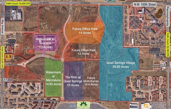

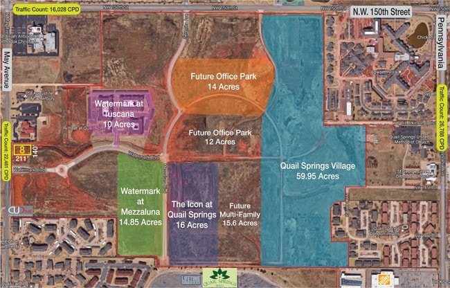
This Property Is For Sale
NEARBY LISTINGS FOR SALE OR LEASE
Property Detail
14613 N May Ave
140736040
Unpltd Pt Sec 12 13N 4W
Religious
UNPLTD PT NE4 SEC 12 13N 4W TH N495FT OF S1155FT OF E1320FT CONT 15ACRS MORE OR LESS & BEG 1320FT W & 556FT N OF SE/C NE4 TH W428.51FT N30.02FT E427.3FT S30FT TO BEG & BEG SE/C NE4 TH W1320FT N660FT E1320FTS660FT TO BEG & BEG 1155FT N OF SE/C NE/4 TH
X
Oklahoma
40109C0155H
Oklahoma
0
51.76 AC
2024
Northwest
108534
Oklahoma City
222,542 SF
Oklahoma City, OK
DEMOGRAPHICS near 14613 N May Ave
1 Mile
3 Mile
5 Mile
2024 Total Population
10,199
74,873
175,406
2029 Population
10,601
76,972
180,007
Pop Growth 2024-2029
+ 3.94%
+ 2.80%
+ 2.62%
Average Age
38
38
38
2024 Total Households
5,357
32,292
73,908
HH Growth 2024-2029
+ 4.33%
+ 3.00%
+ 2.70%
Median Household Inc
$53,977
$71,100
$73,575
Avg Household Size
1.80
2.30
2.30
2024 Avg HH Vehicles
1.00
2.00
2.00
Median Home Value
$234,889
$258,340
$237,941
Median Year Built
2001
1995
1991
Nearby Places
Map Layers
Map Styles
 Street
 Aerial
- Restaurants
- Banks
- Shops
- Fitness
- Groceries
PUBLIC TRANSPORTATION
AIRPORT
Will Rogers World
DRIVE
WALK
Distance
Will Rogers World
30 min
18.6 mi
Freight Ports
Tulsa Port Of Catoosa
DRIVE
WALK
Distance
Tulsa Port Of Catoosa
130 min
120.5 mi
Nearby Properties
Address
Land Use
TOTAL SIZE
Lot Size
Zoning
Address
Land Use
TOTAL SIZE
Lot Size
Zoning
140,312 SF
7.91 AC
C-3
Address
Land Use
TOTAL SIZE
Lot Size
Zoning
294,327 SF
14.04 AC
PUD
Address
Land Use
TOTAL SIZE
Lot Size
Zoning
460,954 SF
24.83 AC
PUD
Address
Land Use
TOTAL SIZE
Lot Size
Zoning
594,334 SF
71.64 AC
C-3
Address
Land Use
TOTAL SIZE
Lot Size
Zoning
41,733 SF
2.63 AC
O-1
Address
Land Use
TOTAL SIZE
Lot Size
Zoning
41,733 SF
2.47 AC
C-3
Address
Land Use
TOTAL SIZE
Lot Size
Zoning
366,844 SF
18.47 AC
PUD
Address
Land Use
TOTAL SIZE
Lot Size
Zoning
376,079 SF
29.77 AC
PUD
Address
Land Use
TOTAL SIZE
Lot Size
Zoning
8,354 SF
16.65 AC
PUD
Address
Land Use
TOTAL SIZE
Lot Size
Zoning
391,776 SF
10.12 AC
PUD
Address
Land Use
TOTAL SIZE
Lot Size
Zoning
304,423 SF
31.20 AC
PUD
Address
Land Use
TOTAL SIZE
Lot Size
Zoning
184,238 SF
7.35 AC
C-3
Address
Land Use
TOTAL SIZE
Lot Size
Zoning
10,811 SF
1.46 AC
PUD
Address
Land Use
TOTAL SIZE
Lot Size
Zoning
358,436 SF
18.03 AC
PUD
Address
Land Use
TOTAL SIZE
Lot Size
Zoning
247,230 SF
22.75 AC
PUD
Address
Land Use
TOTAL SIZE
Lot Size
Zoning
10,635 SF
1.49 AC
PUD
Address
Land Use
TOTAL SIZE
Lot Size
Zoning
297,836 SF
15 AC
PUD
Address
Land Use
TOTAL SIZE
Lot Size
Zoning
302,058 SF
23.78 AC
PUD
Address
Land Use
TOTAL SIZE
Lot Size
Zoning
227,714 SF
14.15 AC
PUD
Address
Land Use
TOTAL SIZE
Lot Size
Zoning
294,250 SF
17.85 AC
PUD
Address
Land Use
TOTAL SIZE
Lot Size
Zoning
291,228 SF
14.15 AC
PUD
Address
Land Use
TOTAL SIZE
Lot Size
Zoning
255,921 SF
9.93 AC
PUD
Address
Land Use
TOTAL SIZE
Lot Size
Zoning
158,078 SF
15.58 AC
PUD
Address
Land Use
TOTAL SIZE
Lot Size
Zoning
12,633 SF
2 AC
C-3
Address
Land Use
TOTAL SIZE
Lot Size
Zoning
191,504 SF
20.03 AC
PUD
Address
Land Use
TOTAL SIZE
Lot Size
Zoning
235,612 SF
28.09 AC
PUD
Address
Land Use
TOTAL SIZE
Lot Size
Zoning
316,212 SF
16.36 AC
PUD
Address
Land Use
TOTAL SIZE
Lot Size
Zoning
279,215 SF
11.58 AC
PUD
Address
Land Use
TOTAL SIZE
Lot Size
Zoning
403,628 SF
15.57 AC
C-3
Address
Land Use
TOTAL SIZE
Lot Size
Zoning
34,734 SF
9.07 AC
PUD
The World's #1 Commercial Real Estate Marketplace
Connect with us
© 2026 CoStar Group
The information above has been obtained from sources believed reliable. While we do not doubt its accuracy we have not verified it and make no guarantee, warranty or representation about it. It is your responsibility to independently confirm its accuracy and completeness. Any projections, opinions, assumptions, or estimates used are for example only and do not represent the current or future performance of the property. The value of this transaction to you depends on tax and other factors which should be evaluated by your tax, financial, and legal advisors. You and your advisors should conduct a careful, independent investigation of the property to determine to your satisfaction the suitability of the property for your needs.