Property Record
S State Highway Mm, Republic, MO 65738
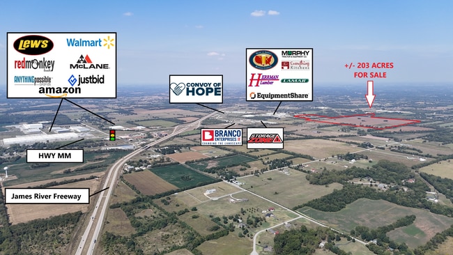

This Property Is For Sale
Property Detail
S State Highway Mm
14-26-300-014
REPUBLIC IRR 165.03A M/L NW1/4 SE1/4 & NE1/4 SW1/4 & SE1/4 NW1/4 & SW1/4 NE1/4 & BEG 712.75 FT S & 969.40 FT E NW COR SW1/4 S 625.87 FT E 419.11 FT N 625 FT W TO BEG 26/29/23
Agriculturalland
GREENE
INC
Missouri
B and X Area of moderate flood hazard, usually the area between the limits of the 100-year and 500-year floods.
165.03 AC
2025
Outlying Greene County
2025
Springfield
004803
Springfield, MO
NEARBY LISTINGS FOR SALE OR LEASE
DEMOGRAPHICS near S State Highway Mm
1 mile
3 mile
5 mile
2025 Total Population
165
9,128
41,365
2030 Population
173
9,533
42,530
Pop Growth 2025-2030
+ 4.85%
+ 4.44%
+ 2.82%
Average Age
38
38
39
2025 Total Households
60
3,493
16,284
HH Growth 2025-2030
+ 5.00%
+ 4.58%
+ 2.90%
Median Household Inc
$103,125
$87,178
$65,921
Avg Household Size
2.70
2.60
2.50
2025 Avg HH Vehicles
2.00
2.00
2.00
Median Home Value
$255,263
$218,158
$217,534
Median Year Built
1998
2002
1995
Nearby Places
Map Layers
Map Styles
 Street
 Aerial
Layers
 Traffic
 Biking
Places
Listings with unknown addresses are not visible on the map
- Restaurants
- Banks
- Shops
- Fitness
- Groceries
PUBLIC TRANSPORTATION
AIRPORT
Springfield-Branson Ntl
Drive
Walk
Distance
Springfield-Branson Ntl
18 min
8.6 mi
Freight Ports
Tulsa Port of Inola
Drive
Walk
Distance
Tulsa Port of Inola
181 min
163.7 mi
Nearby Properties
Address
Land Use
TOTAL SIZE
Lot Size
Zoning
Address
Land Use
TOTAL SIZE
Lot Size
Zoning
112.47 AC
INC.
Address
Land Use
TOTAL SIZE
Lot Size
Zoning
359,722 SF
117.25 AC
INC
Address
Land Use
TOTAL SIZE
Lot Size
Zoning
82.16 AC
Address
Land Use
TOTAL SIZE
Lot Size
Zoning
320,532 SF
33.54 AC
INC
Address
Land Use
TOTAL SIZE
Lot Size
Zoning
Address
Land Use
TOTAL SIZE
Lot Size
Zoning
5.02 AC
Address
Land Use
TOTAL SIZE
Lot Size
Zoning
1.55 AC
INC
Address
Land Use
TOTAL SIZE
Lot Size
Zoning
10.53 AC
INC.
Address
Land Use
TOTAL SIZE
Lot Size
Zoning
3.53 AC
INC
Address
Land Use
TOTAL SIZE
Lot Size
Zoning
154,470 SF
16.97 AC
INC
Address
Land Use
TOTAL SIZE
Lot Size
Zoning
8.12 AC
INC
Address
Land Use
TOTAL SIZE
Lot Size
Zoning
28.99 AC
Address
Land Use
TOTAL SIZE
Lot Size
Zoning
7.95 AC
INC
Address
Land Use
TOTAL SIZE
Lot Size
Zoning
13.80 AC
C-2
Address
Land Use
TOTAL SIZE
Lot Size
Zoning
148,940 SF
10.08 AC
M-2
Address
Land Use
TOTAL SIZE
Lot Size
Zoning
Address
Land Use
TOTAL SIZE
Lot Size
Zoning
Address
Land Use
TOTAL SIZE
Lot Size
Zoning
11.87 AC
INC
Address
Land Use
TOTAL SIZE
Lot Size
Zoning
8.52 AC
INC
Address
Land Use
TOTAL SIZE
Lot Size
Zoning
6.15 AC
INC
Address
Land Use
TOTAL SIZE
Lot Size
Zoning
130,365 SF
8.73 AC
M-2
Address
Land Use
TOTAL SIZE
Lot Size
Zoning
12.44 AC
Address
Land Use
TOTAL SIZE
Lot Size
Zoning
7.99 AC
INC
Address
Land Use
TOTAL SIZE
Lot Size
Zoning
7.98 AC
INC
Address
Land Use
TOTAL SIZE
Lot Size
Zoning
Address
Land Use
TOTAL SIZE
Lot Size
Zoning
91,150 SF
10.30 AC
R-1;C-2
Address
Land Use
TOTAL SIZE
Lot Size
Zoning
13.42 AC
INC
Address
Land Use
TOTAL SIZE
Lot Size
Zoning
3.12 AC
INC
Address
Land Use
TOTAL SIZE
Lot Size
Zoning
7.19 AC
O-2
Address
Land Use
TOTAL SIZE
Lot Size
Zoning
1,072 SF
9.17 AC
M-1
The World's #1 Commercial Real Estate Marketplace
Connect with us
© 2026 CoStar Group
The information above has been obtained from sources believed reliable. While we do not doubt its accuracy we have not verified it and make no guarantee, warranty or representation about it. It is your responsibility to independently confirm its accuracy and completeness. Any projections, opinions, assumptions, or estimates used are for example only and do not represent the current or future performance of the property. The value of this transaction to you depends on tax and other factors which should be evaluated by your tax, financial, and legal advisors. You and your advisors should conduct a careful, independent investigation of the property to determine to your satisfaction the suitability of the property for your needs.